Weekend storm: Parts of Massachusetts could see half a foot of snow
A storm on track to move into Massachusetts this weekend is expected to bring snow, rain, and strong wind gusts.
Friday featured steady rainfall through dinnertime, and the drizzly, foggy conditions will linger into Saturday morning. Things will then dry out before an impactful storm arrives during the daylight hours on Sunday.
“This is coming in a mix of rain and snow,” Boston 25 Chief Meteorologist Kevin Lemanowicz said in his Friday evening forecast. “As the day wears on and into the night, the rain/snow line collapses and will all finish up as snow.”
Lemanowicz shared an “early-look” snow map Friday evening that showed the chance for a half foot of snow in some parts of the Bay State.
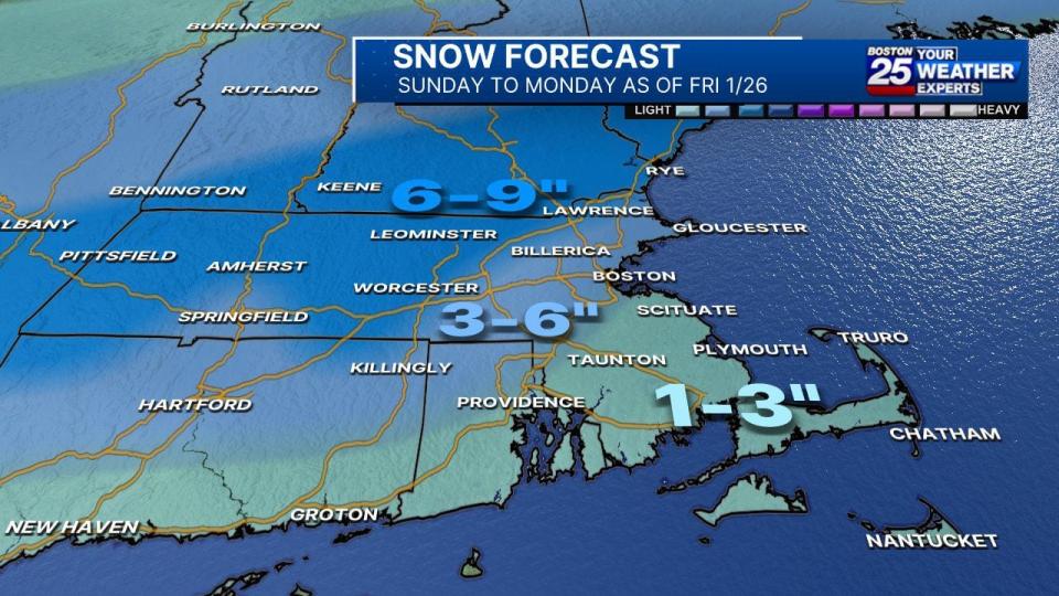
“The way we’re thinking about this right now is a lesser chance for snow in southeastern Massachusetts and finishing up with three to six inches around Boston and potential for six to nine inches in Worcester and into the hills and higher elevations. ” Lemanowicz says.
There will likely be more mixing of rain during the day on Sunday for points south of the Mass. Pike and along the coastline. Southeastern Massachusetts, including Cape Cod and the Islands, will start with mainly rain before a late flip to snow.
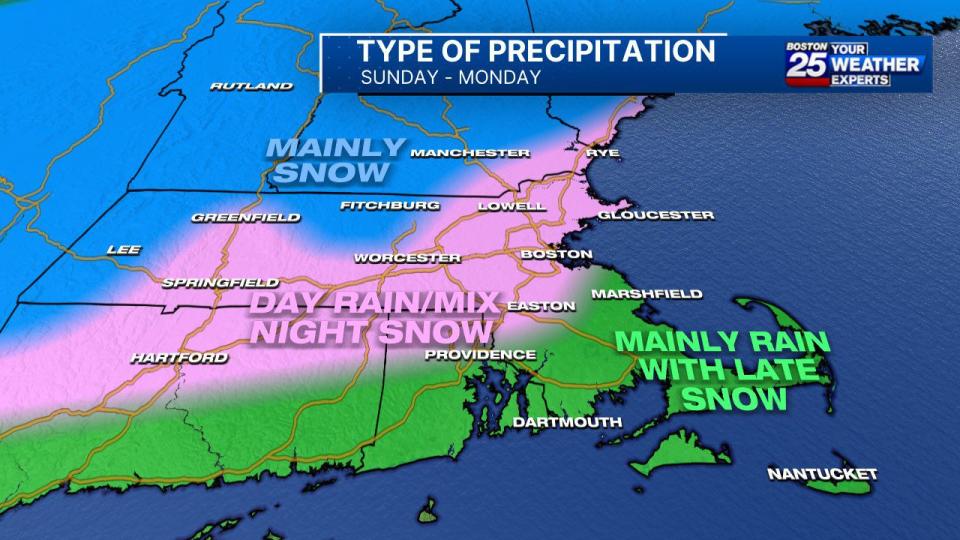
Temperatures will be mild enough during the day on Sunday to limit snow accumulation in some areas but overnight into Monday could become a problem.
“Most, if not all, of the accumulation for Boston/I95 and southeast MA will happen Sunday night. Monday morning looking like a mess,” Lemanowicz says.
Snow will look to taper off around mid-day Monday before dry, chilly weather moves in by the middle of the week.
UPDATED SNOW MAP.. This is for Sunday to Monday. Most, if not all, of the accumulation for Boston/I95 and southeast MA will happen Sunday night. Monday morning looking like a mess. Talking about it @boston25 from 5-7 p.m. pic.twitter.com/5bAio82pos
— Kevin Lemanowicz (@KevinBoston25) January 26, 2024
For the latest updates, visit the Boston 25 Weather Page.
Download the FREE Boston 25 News app for breaking news alerts.
Follow Boston 25 News on Facebook and Twitter. | Watch Boston 25 News NOW

