Weird weather: Temps may be higher in Maine than in Florida, National Weather Service predicts
Floridians know May is one hot month.
On Thursday and Friday, however, it could be hotter in Maine and Minnesota than in the Sunshine State. That's according to the National Weather Service's prediction center.
What the National Weather Service predicts
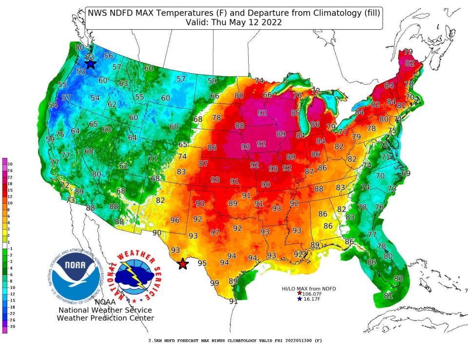
National Weather Service tweeted a pair of heat maps Tuesday evening: "Ridging over the central U.S. will pump warm air into the Midwest and Northeast, while a low in the western Atlantic will cool temperatures along the East Coast through Friday. This means that Thurs/Fri high temperatures in parts of Maine could be higher than those in Florida!"
According to the maps from the National Weather Service, temps on Thursday show a high of 99 in Texas and 92 in Minnesota, while Maine and Vermont have a high of 82 and 84, respectively. The Thursday map shows a high of 86 in Southwest Florida, with upper 70s and a high of 81 along the East Coast of the state.
Hurricane season is coming: Here's your hurricane to-do list for large trees
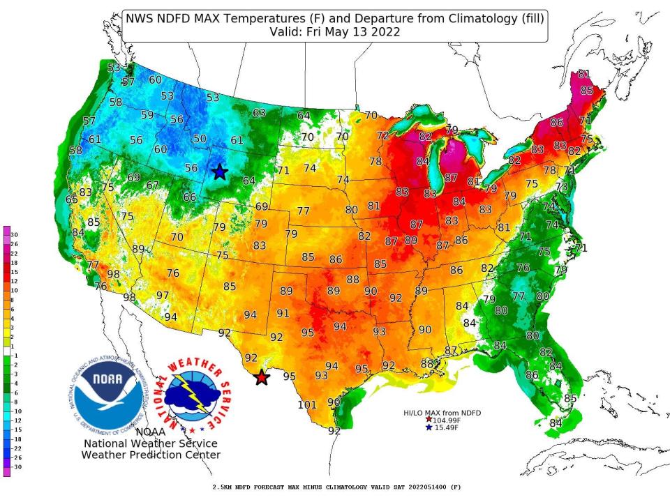
The weather service prediction center map shows higher temps for Friday in Florida, with a high of 86 in Southwest Florida and a high of 86 in Vermont that day.
What the Weather Channel predicts
The Weather Channel predicted record-setting high temps, particularly in the Midwest and Texas. In a Wednesday morning tweet with a series of maps and population affected, the weather service asked, "How are we liking the temps this week? Wish it was even hotter, or prefer things the cooler side?"
According to the Weather Channel tweet, populations of roughly 52 million people will feel the highs above 90 on Wednesday (today), 56 million on Thursday and 39 million on Friday.
How are we liking the temps this week? Wish it was even hotter, or prefer things the cooler side? 🤔 pic.twitter.com/jeVI7dLy3i
— The Weather Channel (@weatherchannel) May 11, 2022
Hmmm: Will the trend of hurricane season unofficially starting in May continue?
National Hurricane Center tracking first tropical wave of 2022, weeks before season starts
It may be hotter in Minnesota than in Florida (for a few days in May)
The National Weather Service Twin Cities account reported Wednesday morning that "temperatures will surge into the 80s Wednesday and 90s Thursday, working with higher humidity levels to produce heat indices in the 90s both days. This will accompany higher chances for thunderstorms both days. Cooler and drier conditions are expected for Friday. #mnwx #wiwx"
Temperatures will surge into the 80s Wednesday and 90s Thursday, working with higher humidity levels to produce heat indices in the 90s both days. This will accompany higher chances for thunderstorms both days. Cooler and drier conditions are expected for Friday. #mnwx #wiwx pic.twitter.com/EvTVzisZwK
— NWS Twin Cities (@NWSTwinCities) May 11, 2022
What is ridging?
The National Weather Service attributes the wacky weather to "ridging over the Central U.S."
But what does ridging in weather mean?
The "Rough Science" section on PBS explains it like this: "Ridges and troughs are often mentioned on the weather forecast. A ridge is an elongated area of relatively high pressure extending from the center of a high-pressure region. A trough is an elongated area of relatively low pressure extending from the center of a region of low pressure. Air in a high pressure area compresses and warms as it descends. This warming inhibits the formation of clouds, meaning the sky is normally sunny in high-pressure areas. But haze and fog still might form. The opposite occurs within an area of low atmospheric pressure."
Ridging over the central U.S. will pump warm air into the Midwest and Northeast, while a low in the western Atlantic will cool temperatures along the East Coast through Friday. This means that Thurs/Fri high temperatures in parts of Maine could be higher than those in Florida! pic.twitter.com/eUF64GVU3S
— NWS Weather Prediction Center (@NWSWPC) May 10, 2022
Please consider subscribing to a USA TODAY Network-Florida newspaper at offers.usatodaynetwork.com/network-regional-florida.
This article originally appeared on Fort Myers News-Press: Florida weather, May: It may be hotter in Maine, Michigan, Minnesota

