'We're choking': How an air quality study is mapping which PVD neighborhoods have the worst air
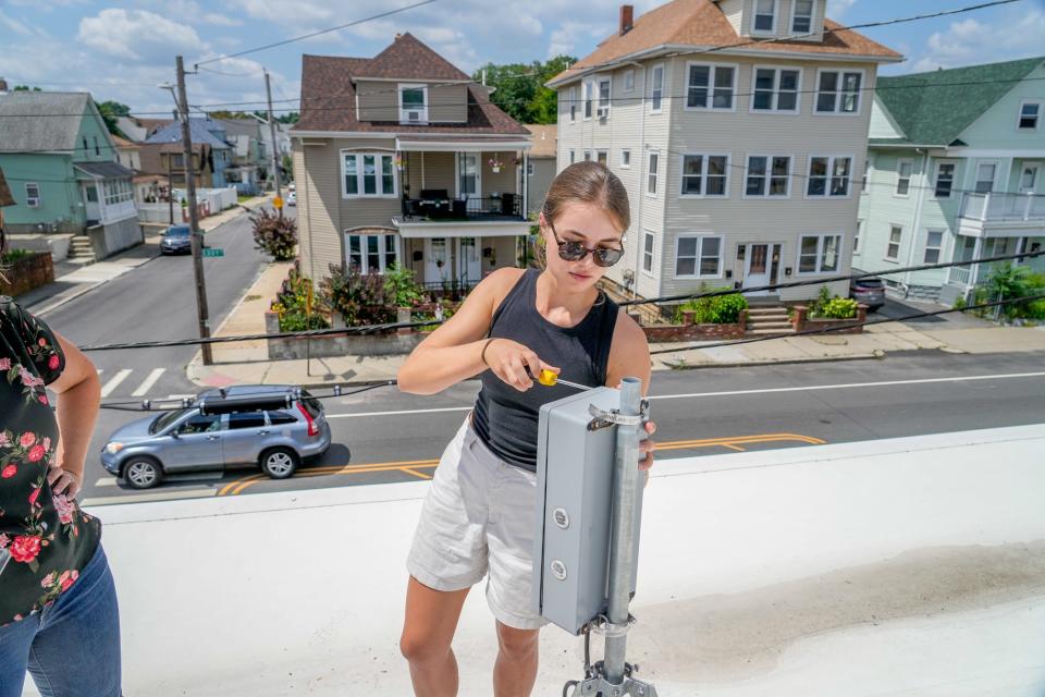
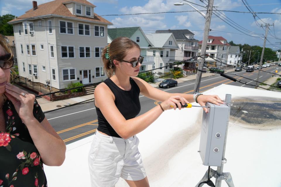
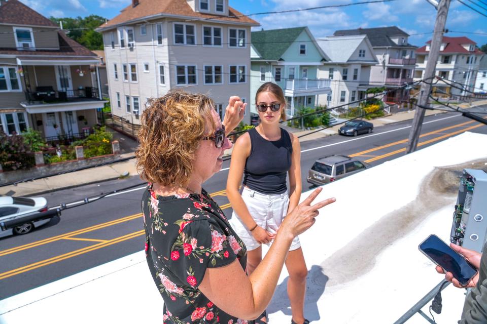
PROVIDENCE — Grace Berg unscrews the faceplate of an anonymous-looking gray box mounted on a tripod. Inside is an array of wires and sensors that are meaningless to a layperson.
But these are the inner workings of a device that's collecting important information about air pollution in Washington Park as part of a project that is putting Providence at the forefront of a global initiative to improve public health through cleaner air.
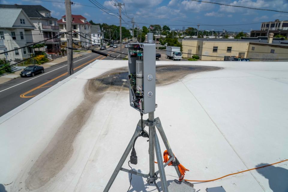
The air quality monitor is one of 22 installed so far by Brown University’s Breathe Providence project. Spread throughout the city, the monitors are measuring everything from tiny airborne particles to carbon monoxide on a neighborhood level.
It’s a hot summer afternoon as Berg, the project coordinator, and Meredith Hastings, an atmospheric chemist who is leading the study, climb a ladder to the roof of Child & Family Rhode Island’s community center on Eddy Street, where the monitor is located. The heat index, a measure that combines temperature and humidity, is well into the 90s and, after explaining how the instrument works, they don’t stay long on the sweltering rooftop.
The conditions are ripe for the formation of ozone, a gas that is beneficial in the atmosphere as a shield from ultraviolet radiation but is a pollutant at ground level, causing breathing problems and lung damage. The main component of smog, ozone forms when emissions from tailpipes, power plants and factories react under sunlight.
Authorities have issued an ozone alert across Rhode Island for the day, but the advisory doesn’t specify which neighborhoods, or even cities or towns, are most at risk.
Breathe Providence has set out to address what its researchers see as a gap in air quality data by investing in a network of measuring instruments that they hope will yield more detailed information that reflects a person’s actual exposure to ozone and other pollutants. One of the goals of the project is to predict when pollution will arise and issue hyperlocal alerts to help residents avoid danger.
For most people who take for granted the safety of the air they breathe, the smoke from wildfires in Canada that blackened the skies over Providence and other cities in America this summer was a reminder of just how bad things can be.
But residents need no reminding in places like Washington Park, a neighborhood where emissions from nearby Route 95 and the Port of Providence are everyday problems and where asthma rates are persistently high.
The members of the Brown team believe their study will shed light on local causes of pollution and help force change for the better.
"The way the government regulates air quality is based on averages,” says Hastings, who is deputy director of the Institute at Brown for Environment and Society. “But we don’t breathe average air.”
Air quality is improving, but disparities persist
The air in Providence is influenced from sources near and far.
Ozone clouds drift north along the I-95 corridor from New York and New Jersey and east from the Ohio Valley, fueled by discharges from heavy industry. They mix with particulates and nitrogen-based pollutants from traffic that courses up and down the highway through the heart of Rhode Island's capital.
Carbon-containing gases vented from storage tanks filled with asphalt and other petroleum products in the Port of Providence area add to the stew, along with emissions from tanker ships making deliveries to the port that burn dirty bunker fuel, diesel trucks that cut along surface streets to pick up loads of gasoline, heating oil and liquefied natural gas, and scrap operations that can send up plumes of dust and smoke.
Despite the continuing sources of pollution, from a big-picture perspective, the air in Providence is safer to breathe now than it used to be.
The average number of high ozone days in the city and its environs has dropped from about two dozen a year 20 years ago to just one or two today, according to the American Lung Association, which analyzes U.S. Environmental Protection Agency data for its annual “State of the Air” report. High particulate days are also down to nearly zero on average per year, and particle concentrations are now well below acceptable levels.
Thank the Clean Air Act for the improvements. Updates in the 1990s to the landmark 1970 law tightened tailpipe regulations and forced jewelry factories and other local polluters to control what they emitted. Further amendments in the 2010s forced coal-burning power plants in the Rust Belt and Appalachia to restrict smokestack discharges that blow into Rhode Island and other downwind states.
Karen Slattery, who started working for the Rhode Island Department of Environmental Management 35 years ago, has seen the changes firsthand.
“We had a lot more sources of pollution and a lot fewer regulations before,” said Slattery, who is now deputy administrator for air resources at the agency.
Air quality, however, can be capricious, dependent as it is on wind, cloud cover and temperature. It’s not like drinking water that often comes from a single reservoir and gets treated at a central plant.
Air composition changes from day to day, even hour to hour. And location within the cityscape makes a big difference. Topography, tree cover, building density and distance from local pollution sources all play a role.
So while it may be true that air quality has improved over time in Providence as a whole, it’s also true that on some days it’s still deficient, and that some neighborhoods are suffering more than others.
How much more is the question.
How hot is it? Providence's treeless neighborhoods magnify summer heat
The government network of air quality monitoring stations, seven of them around Rhode Island operated by the DEM, isn’t set up to collect data at a resolution that can differentiate between Providence’s neighborhoods. Only a handful of the stations are actually located in Providence County, and they don’t all measure the same pollutants.
That’s where Breathe Providence comes in. Hastings, Berg and the other members of the Brown team are placing at least one of their monitors in every neighborhood in Providence. The goal is to blanket the city with 25 stations.
The idea of hyperlocal air monitoring has gained traction in recent years as a way of collecting evidence of overlooked pollution sources to force governments to take action. A project in the San Francisco Bay area known as BEACO2N, started by researchers at the University of California, Berkeley, is one of the pioneers of measuring street-level pollution.
Similar efforts underway in London, Paris, Jakarta and other major cities will be built upon by the creation of Breathe Cities, a $30 million initiative from the Clean Air Fund, Bloomberg Philanthropies and C40 Cities to expand air monitoring across the globe.
Hastings presents this type of work as a counterpoint to what she describes as a “one size fits all” approach by the government to regulating air quality that, she argues, masks local problems.
“The Clean Air Act has been a huge success for the United States,” she says. “It just hasn’t been a huge success for everyone.”
Truck traffic and port contribute to air pollution
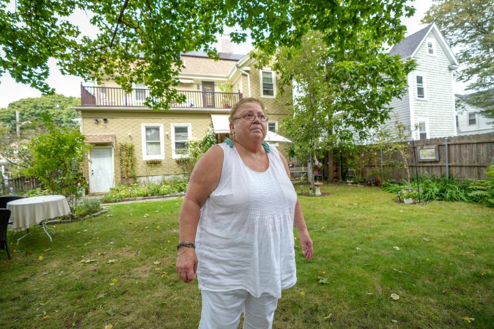
Some mornings, Linda Perri stays indoors because the air outside her house in Washington Park is so bad.
“I can’t even go out in my yard in the morning to drink my coffee, because I can’t breathe,” says Perri, who has asthma and sarcoidosis, a condition that affects the lungs.
Perri, president of the Washington Park Neighborhood Association, says she complains to the DEM about air quality in the neighborhood about half a dozen times a year, mainly when odors waft in from one of several asphalt operations in the Port of Providence area. She worries that airborne carcinogens or other dangerous chemicals are being carried from the port, which is just a few hundred feet from the nearest homes.
The neighborhood occupies land that was once farmed by the descendants of Rhode Island founder Roger Williams. Named for a horse track that operated there in the mid-1800s, the area was divided into residential lots around the turn of the 20th century. Housing demand picked up during the two world wars, when shipbuilding and other industrial development took off along the Providence waterfront.
Today, Washington Park is a hive of life, packed with one- and two-family homes crowded onto postage-stamp-sized lots. The Port of Providence nearby has grown into one of Southern New England’s largest industrial hubs, used for the import and distribution of asphalt, cement, chemicals, diesel, propane, heating oil, gasoline and natural gas. Eleven of the 13 facilities listed in the U.S. Environmental Protection Agency’s Toxic Release Inventory for Providence are in the port area.
The area has accounted for more than a third of all odor complaints in Providence over the last decade, according to DEM data. Hot spots include the port itself, as well as a range of activities on nearby Allens Avenue, from a pair of riverfront scrap metal facilities to the Narragansett Improvement Company's asphalt manufacturing operation to Sprague Energy's asphalt storage tanks.
Like other places that disproportionately shoulder the burdens of pollution, Washington Park and the neighborhoods around the port are predominantly low-income communities of color. They have the highest asthma rates in Rhode Island, which ranks above all other states for prevalence of the disease.
Breathe Providence set up the monitoring station atop the Child & Family center because of its location in the heart of the neighborhood. The team worked with community leaders to focus their research on the city neighborhoods hardest hit by pollution and chose recreation centers, schools and libraries for their sites because they want to know what the air is like not just where people live but also where they gather. They started installing the devices last year, and the work has continued this summer.
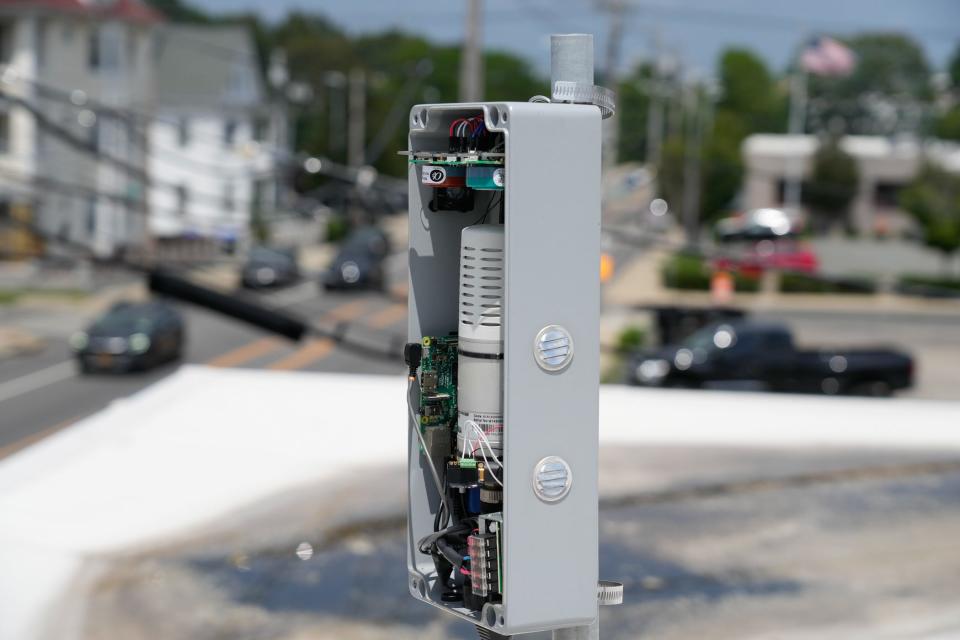
The monitors are the same ones used by the BEACO2N project in California. Each one is about the size of a shoebox. A small fan pulls air inside, where sensors measure levels of carbon monoxide, particulate matter, ozone, nitrogen oxides and carbon dioxide. The data is collected around the clock and sent by wireless transmitter to Hastings and her team in real time.
Not only are the devices smaller than government stations, which can be the size of shipping containers, but they are also a fraction of the cost, the product of technological advancement in just the last few years.
Because the instrumentation is less sophisticated, however, it’s taking time to calibrate measurements for some of the pollutants, including ozone. The only data that’s available to the public right now is for carbon dioxide levels.
But the researchers are seeing disparities between neighborhoods already, finding more pollution near the highways and the port and, not surprisingly, much lower concentrations in the leafy neighborhood around Blackstone Park on the city's more affluent East Side.
For the day that Berg and Hastings give the tour of the monitoring station at the Child & Family center, they’re unable to provide ozone data. But Berg analyzes measurements of carbon monoxide, finding differences across the city. The highest levels of the pollutant are in Washington Park.
It reflects what Perri says she experiences on a daily basis.
“We're being exposed day in and day out, year after year,” she says. “We’re choking here.”
Climate change brings uncertainty
If there’s hope for Providence’s overburdened neighborhoods, it can be found in climate policy. Any regulations aimed at cutting greenhouse gas emissions would also mean the reduction of other air pollutants.
Gov. Dan McKee’s proposal to phase out new sales of gasoline-powered cars and ramp up the adoption of electric vehicles would mean less particle pollution and carbon monoxide emissions on Rhode Island’s roads and highways. Federal programs could force the retirement of coal-fired power plants in upwind states. And less reliance on fossil fuels could eventually cause industrial operations in the Port of Providence to scale back.
But climate change also presents new problems when it comes to air quality. The Canadian wildfire smoke is Exhibit A.
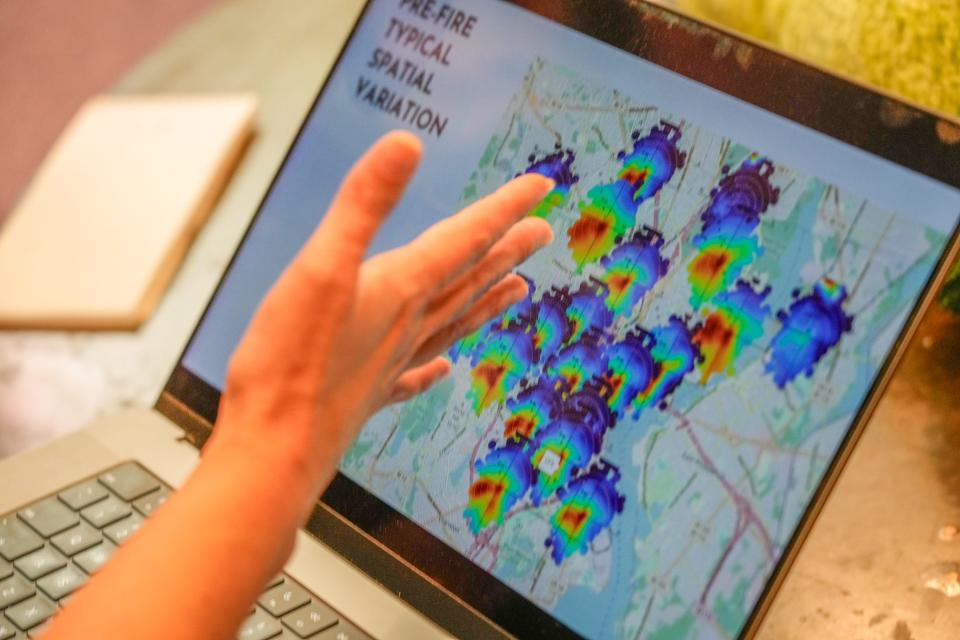
The Breathe Providence monitors captured the effect when the smoke was at its worst in Rhode Island in early June. Every station lit up, with some recording particle levels at seven or eight times the EPA standard at the peak around 6:30 p.m. on June 6.
More: He’s creating several football fields’ worth of shade in neighborhoods needing it the most
It wasn’t just that measurements spiked. They stayed above the standard for long periods over several days, meaning Rhode Islanders were being exposed to high particle levels for nine or 10 hours a day. Dan Fitzgerald, director of advocacy for the American Lung Association in Rhode Island, says the number of high particle days for the state this year will be well above average as a result.
Hastings points to other potential negative impacts as the Earth continues to warm. Hotter, longer summers are linked to higher smog levels, not only because heat helps accelerate the chemical reactions that create ozone but also because higher temperatures will mean more air conditioning, driving up emissions that contribute to formation of the gas.
Heat also exacerbates asthma and other respiratory conditions, adding to the risks for people who may already be suffering from ozone or particle pollution, said DEM director Terry Gray.
“I think we’ll start to see different problems,” he says. “The wildfire smoke is one very visual example. I think with longer, hotter summers we’ll see more respiratory issues and more people susceptible to the impacts of air pollution.”
The DEM, as the state agency empowered to enforce the Clean Air Act in Rhode Island, goes above and beyond what’s required by law to monitor air quality. The agency has embarked on its own research into pollution hot spots in Providence, finishing one study around Interstate 95, nearing the completion of another focused on the port, and applying for funding to do its own street-by-street analysis using portable monitors. And Slattery says her office remains open-minded about the data being collected by Breathe Providence and how it could affect enforcement and policy.
But even Gray acknowledges that more can be done to understand and start to address the inequities affecting urban neighborhoods when it comes to a host of environmental issues ― not just air quality, but also tree cover and access to green space. The agency is finalizing a new environmental justice policy that is aimed at putting a new focus on underserved communities.
“It’s an acknowledgment that we need to do more,” Gray said.
Addressing asthma and other public health problems
At a meeting on environmental issues led by Providence City Council members, Hastings explains how Breathe Providence is aiming to make the connection between air monitoring and public health.
Asthma rates aren’t just high in Washington Park, she tells the members of the council's Special Committee on Environment and Resiliency. They’re also elevated in South Providence, Olneyville and Smith Hill. With its small number of stations, the government’s monitoring network can’t get at the reason. Is there a single cause, she asks, or several?
“We’re not measuring where the highest concentrations of asthma are occurring,” Hastings says. “Do we really know the connection between air quality in our city and the asthma hazard rates?”
She talks about reaching out to local health equity zones and the state health department and working with the Brown School of Public Health to start looking for answers in the air quality data her team is collecting.
She describes the potential for future policy changes if the causes of the disparities are identified. Perhaps Rhode Island could invest in clean-energy projects in New York or New Jersey, where so much smog originates. Or Providence could regulate the timing of truck traffic to reduce spikes in emissions.
Supporters of Breathe Providence believe its findings can make a difference in cracking down on the sources of pollution afflicting Providence’s most disadvantaged neighborhoods.
“I think when we can really start empowering residents about the air we breathe, then we can really start doing something about it,” says Fitzgerald.
That’s what Hastings and the rest of her team are counting on when it comes to asthma and other health problems caused by poor air quality.
“It affects our whole health care system and the amount of money we pay in taxes,” she says. “We think it’s not our problem, but it is. It’s all combined and all related.”
The Providence Journal is investigating the effects of a rapidly heating planet on people who live in our city. Follow along with "City on Fire" as we report the struggle with summer temperatures. This is part of the USA TODAY project Perilous Course. Contact journalist Alex Kuffner (akuffker@providencejournal.com) to be included in a story if you have been affected by heat: expense of air conditioning or lack of it, health risks, less access to green space, concern about pets and animals in the summer conditions, worry about an older loved one, etc.
This article originally appeared on The Providence Journal: New Providence air pollution study is pinpointing health danger zones

