Wet and waterlogged: Northeast rainstorm caps wettest December on record for some


The final month of 2023 will go into the record books for most of the country as being warmer than average, but what about precipitation? If you live in the Northeast, you already know the answer.
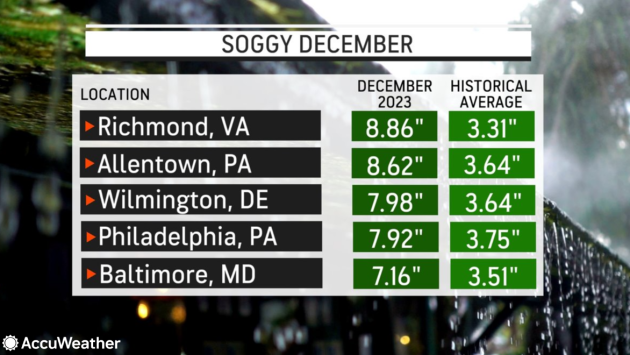
December has been a wet one for much of the mid-Atlantic and Northeast, due to frequent rainstorms packed with flooding downpours. For Allentown, Pennsylvania, and Richmond, Virginia, there is now no other December when it has been wetter while scores of other cities have notched a spot among the top 10.
Because the month has featured more rainy days than dry ones, many are pining for drier times, or perhaps for some snow to replace the frequent rain, as the calendar turns to 2024. Fortunately for them, AccuWeather's team of long-range experts has some better news to report.
 |
From big cities to smaller towns, the rain gauges kept filling up through the month, and in some spots, the month will go down as the wettest December on record. This is an especially noteworthy accomplishment since modern, reliable weather records in some areas date back over 100 years.
In Allentown, Pennsylvania, 8.62 inches of rain or liquid-equivalent precipitation had fallen through Friday, beating the previous wettest December on record of 7.89 inches from 1973. What makes this year's precipitation amount even more impressive is that it was nearly all rain, as only a trace of snow fell, standing in contrast to December 1973, when over 7 inches of snow was measured, with its melted equivalent included in the tally.
 |
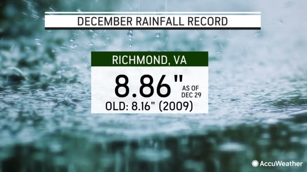
Richmond, Virginia, also recorded its wettest December following this week's storm. As of Saturday, 8.87 inches had fallen, edging out the old high water mark (pun intended) of 8.16 inches from 2009. Similar to Allentown, that month also included quite a bit of snow (7.4 inches) while nearly all of the precipitation this year has fallen in the form of rain.
For both cities, the record rain this month has come via four distinct storms separated by about a week that all followed a similar path.
 |
"The month of December has been wet due to a storm track that has come from the southern Plains and generally moved northeastward toward the Great Lakes and Northeast," said AccuWeather Senior Meteorologist Joe Lundberg. "There has been no downstream blocking in the northern Atlantic Ocean that might have steered those storms farther south and east out to sea."
Without that blocking, which would come courtesy of a fair weather high-pressure system, the storms are able to gather copious amounts of moisture in the Gulf of Mexico and tropics before moving up the East Coast and soaking millions across the mid-Atlantic and Northeast, explained Lundberg.
Philadelphia moved into the third-wettest December on record after Wednesday's storm, with 7.92 inches as of Saturday, behind only 1996 and 2009. New York City has also made the top-10 list after Friday, with 6.71 inches reported as of midnight Friday night, good for 9th place.
 |
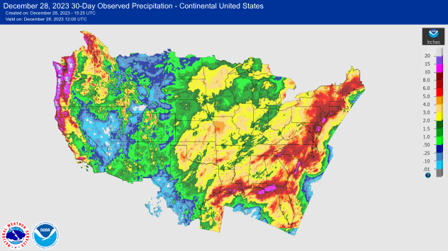
Multi-sensor observed precipitation over the last 30 days across the United States, as of Thursday morning, Dec. 28, 2023. (NOAA/AHPC) |
In most cities, enough precipitation for two Decembers has to fall to make that upper echelon of wet Decembers. In addition to the cities noted above, that happened in Salisbury, Maryland, (226 percent of the historical average through Dec. 30) and Wilmington, Delaware, (213 percent).
As a result of the repeated rounds of rain, numerous streams, creeks and larger rivers are running high. At one point on Thursday, at least 45 river gauges from the Carolinas to New England were experiencing minor to moderate flooding conditions, with dozens more gauges just below flood stage, according to National Weather Service river forecast centers. Streams and rivers will recede through the weekend.
The active weather pattern with a storm track that has led to the numerous rainstorms in the East has been one lacking any sustained cold air. According to AccuWeather's long-range forecasting team, which includes Lundberg, things are about to change, but he warns it will not be like flipping a switch.
"Early in January, the storm track may end up more suppressed to the south, leading to a chillier-but by no means cold-pattern for the mid-Atlantic and Northeast," said Lundberg. "This will also make for a quieter stretch of weather with less precipitation."
 |
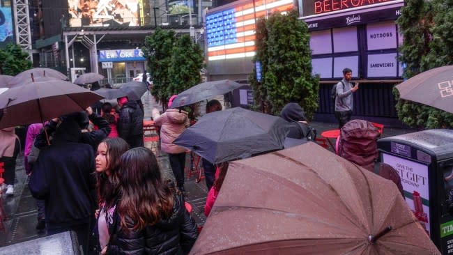
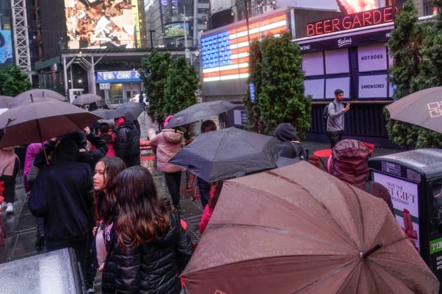
Pedestrians take cover under umbrellas as they walk through a wet Times Square in New York, Monday, Dec. 18, 2023. (AP Photo/Seth Wenig) |
The forecast for drier air over the next couple of weeks will be disappointing news to snow lovers, who are looking for some more of the white stuff in a second consecutive winter season that has been severely lacking. For example, in Baltimore, Washington, D.C., and Boston, the percentage of the historical average of snow received through this point in the season is a meager 0, 7 and 2 percent, respectively.
However, as the old saying says, good things come to those who wait.
"Our long-range forecasting team is still forecasting that changes will take place later in January that can lead to colder air entering North America," added Lundberg. "With that may come opportunities for more typical winter storms late in the month and into February."
Want next-level safety, ad-free? Unlock advanced, hyperlocal severe weather alerts when you subscribe to Premium+ on the AccuWeather app. AccuWeather Alerts™ are prompted by our expert meteorologists who monitor and analyze dangerous weather risks 24/7 to keep you and your family safer.
