Wet and windy pattern returning to Northwest while intense heat builds in California, Arizona

AccuWeather meteorologists monitoring the weather setup across the western United States say that there will be contrasting patterns from the Northwest to the Southwest into the first half of this week.
Some locations will face damp and windy conditions as a storm spreads rain and showers along the Northwest coast while residents across the Southwest will be stuck under an area of high pressure that will usher in high temperatures reaching into the 100s Fahrenheit.
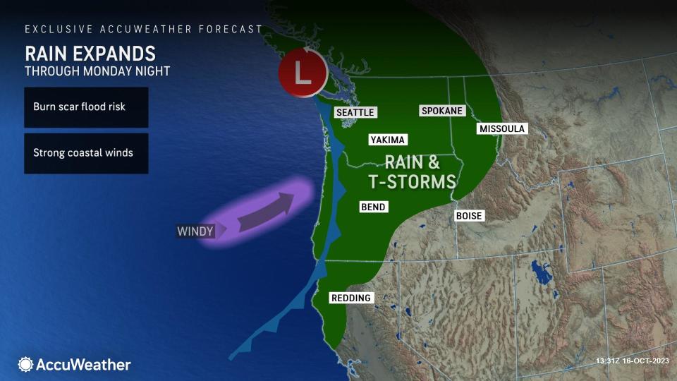
A storm advancing into the Pacific Northwest early this week will bring rounds of rain from parts of Northern California to northern Idaho and far northwestern Montana. Into Tuesday morning, a cold front will track into the coast and spark a brief stretch of stormy conditions.
As this feature approaches the Northwest coast, there will be an uptick in winds from Washington to Oregon. Winds late Sunday can reach gusts upwards of 45 mph over the open waters. However, on Monday, locations directly along the coast like Westport, Washington, can observe winds from 20-30 mph with gusts to 35 mph.
Small craft advisories and gale warnings were put in place across the region, warning boaters of rough seas and gusty winds through at least Tuesday evening.
Elevated winds are expected to push inland from the coast to the northern Rockies through Tuesday night, with general wind speeds ranging from 25-35 mph. A high wind warning in addition to a wind advisory was put in effect for numerous counties in western and central Montana through Tuesday evening. Strong gusts blowing across the Rocky Mountain Front can reach speeds of 60-70 mph during this time, which can impact travelers across the region, particularly high-profile vehicles and trucks.
In addition to the wet, windy weather, the storm will bring temperatures down briefly into Tuesday across parts of the Northwest states. Cities like Portland are expected to observe maximum temperatures returning to the mid-60s through Tuesday, which is near the historical average for mid-October.
Residents in Washington in locations such as Seattle and Yakima can notice a minor temperature change into Tuesday, with values just a few degrees below temperatures observed over the weekend.
The drop in temperature can even result in some snow across the highest elevations of the northern Cascades and northern Rocky Mountains although forecasters say that snow levels are not expected to drop significantly early this week, noting that the highest levels of Glacier National Park may be among some of the few locations to observe a few snowflakes by Tuesday.
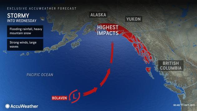
Former Super Typhoon Bolaven has been churning across the Pacific waters over the weekend but now has its sights set on the Gulf of Alaska early this week. AccuWeather meteorologists say that impacts of rain and wind will spread across the Aleutian region along the peninsula to Southeast locations through Wednesday.
 |
"Moisture from Tropical Wind and Rainstorm Bolaven may enhance showers through the Aleutians into early Monday, but the more significant impacts related to Bolaven will arrive late Monday night or early Tuesday, when wind and rain will pick up for much of southeastern Alaska," explained AccuWeather Meteorologist La Troy Thornton.
Thornton added that gusts to 50 mph are possible in southeastern Alaska Tuesday, with gusts over 40 mph in store for the Aleutians.
A gradual improvement in conditions is expected from the middle to late part of the week across the region, but repercussions downstream can be felt across the western U.S. as the week continues. A northward bulge in the jet stream across the West Coast can become more pronounced as this feature pushes eastward, resulting in a stretch of drier, warmer conditions across Northwest states.
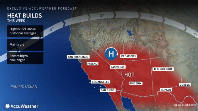
In contrast to the stormy conditions across the Northwest early this week, locations to the south will feature climbing temperatures and a stretch of dry, sunny weather. A building ridge of high pressure over the Southwest will be the driving force for the warm pattern.
Places like downtown Los Angeles and Las Vegas are expected to have high temperatures within a few degrees of 90 most days this week, which is roughly 10 degrees above typical mid-October values. Meanwhile, locations across far southeastern California and southern Arizona will have temperatures rising above the 100-degree mark.
 |
"Although Phoenix is no stranger to 100+ degree warmth, the stretch of warmth upcoming is impressive even by Phoenix standards given the time of year," AccuWeather Senior Meteorologist Dan Pydynowski said. Just Monday, the temperature hit 105 F in Phoenix, which broke the record of 102 set in 2020 for the date.
The 105-degree reading was the latest ever in the year for a high temperature so extreme. The prior record was a 105-degree F high temperature on Oct. 10, 1991.
The building warmth is expected to expand northward to reach parts of the Northwest by late in the week, allowing temperatures there to rebound from the brief, cooler weather that will be ushered in by the cold front to arrive next Monday and Tuesday.
Want next-level safety, ad-free? Unlock advanced, hyperlocal severe weather alerts when you subscribe to Premium+ on the AccuWeather app. AccuWeather Alerts™ are prompted by our expert meteorologists who monitor and analyze dangerous weather risks 24/7 to keep you and your family safer.
