We've seen 278 days since a hurricane hit. But the tropics are waking up
- Oops!Something went wrong.Please try again later.
It has been 278 days without an incident.
The time since Hurricane Nicole’s landfall last November has passed without tropical incident on the U.S. coastline. While six months of that was the off-season, those 278 days do include a significant chunk of the 2023 hurricane season.
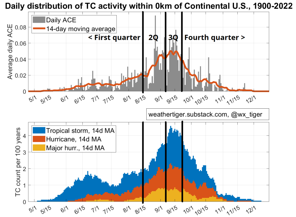
As of the Ides of August, historically about one-eighth of all Atlantic tropical activity is behind us. Because early-season storms tend to develop closer to land, U.S. landfall activity is about 25% complete. Florida specifically is a little under 20% done with the season.
However, the historical curve gets steep from here, a hill that even Kate Bush would struggle to run up.
If hurricane season were divided into quarters of roughly equal U.S. landfall activity, the first quarter would run from mid-May to Aug. 14. The entire second quarter would be stuffed into the next three weeks, and the third quarter would run just sixteen days between Sept. 6 and 21.
The Atlantic is starting to fire up; keep an eye on the western Gulf
The Atlantic is starting to wake up from an extended period of quiet as this climatological five-pound bag approaches, but there remain no threats to Florida or the U.S. coast over the next five days.
The only area to watch as a possible medium-range risk for U.S. impacts is the western Gulf of Mexico in the middle of next week. There’s nothing to see now, but there are indications a tropical wave crossing the Florida Straits this weekend may move into a pocket of low-shear conditions once it enters the Gulf.
With a stout ridge of high pressure over the Midwestern U.S. next week, this disturbance will be steered west or west-northwest across the Gulf at a decent clip. That means it’ll have limited time to turn into an organized system.
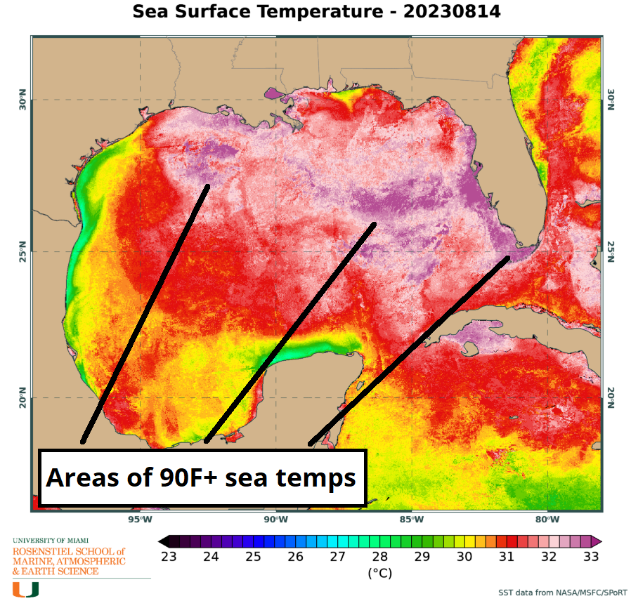
Still, with the Gulf running anywhere from two to six degrees above normal and pushing 90 degrees in many areas, even a couple of days over water is enough time to stir up some light to moderate tropical mischief. Whether it develops or not, this wave should bring some increased rain chances to Texas or Louisiana next week, and the western Gulf Coast should keep an eye on it.
Bears watching, but only at a guarded one bear out of five potential bears.
No foreseeable tropical threat unless...
Elsewhere, the eastern Tropical Atlantic may well go back on the board in the upcoming week, but not in a way that is concerning on our side of the pond.
Two tropical waves are tangled up in a monsoon trough dangling off the West African coast, producing disorganized convective activity. While the details are uncertain, this trough may break into more distinct disturbances between now and the weekend, with the eastern wave rolling off Africa today the most likely to develop into a depression or storm.
A chaotic interaction between multiple potential systems makes predicting exactly what will transpire difficult, but ultimately anything (or things) that develop in the eastern Atlantic are not a threat to U.S. shores.
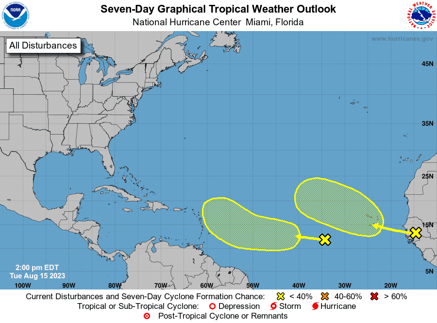
Upper-level lows in the central subtropical Atlantic should drag any potential storm far enough north that it would eventually turn out to sea, and shear and dusty air are also lurking northwest of the disturbances to boot.
Overall, don’t be surprised if one or even two storms develop in the eastern half of the Atlantic in the next week or so, but there are zero concerns out this way.
Into the last week of August, the Atlantic looks poised to be favorable for tropical waves to develop, as is the typical fashion heading into the peak weeks of the season. However, most long-range ensemble models suggest that troughing over the East Coast starting in about 10 days would probably protect the U.S. from storm threats from the east.
If anything were to theoretically organize in the Gulf or western Caribbean in late August, this steering pattern could eventually put the Gulf Coast at risk.
We’ll see, but there is nothing to worry about for the foreseeable future.
May your heat wave wish not come true
In the meantime, the weather story from Texas to Florida has been a grim combination of unusual heat and extreme dewpoints pushing heat indices well out of the normal bad range of typical summer swelter.
Conditions have been so dire that I’ve heard a few of you actually wishing for a (weak) tropical system just to bring some rain and snap us out of our misery.
Folks, let’s not tempt fate here. If books, movies, and TV teach us anything, it’s that wishes are only granted ironically.
With Gulf and Southwestern Atlantic water temperatures way above normal, please keep that monkey’s paw action to yourselves. Besides, no supernatural bargaining is necessary, as Gulf Coast temperatures are likely to retreat to more familiarly uncomfortable August ranges in the week ahead.
Here’s wishing instead for more days of that incident-free streak. Keep watching the skies.

Dr. Ryan Truchelut is chief meteorologist at WeatherTiger, a Tallahassee start-up providing forensic meteorology and expert witness consulting services, and agricultural and hurricane forecasting subscriptions. Get in touch at ryan@weathertiger.com, and visit weathertiger.com for an enhanced, real-time version of our seasonal outlook.
This article originally appeared on Tallahassee Democrat: Florida hurricane forecast for mid-to-late August. What to watch
