Whatcom County deploys additional resources as floodwaters from the Nooksack return
This is a developing story. Check back to bellinghamherald.com for updates.
To sign up for breaking news alerts, click here.
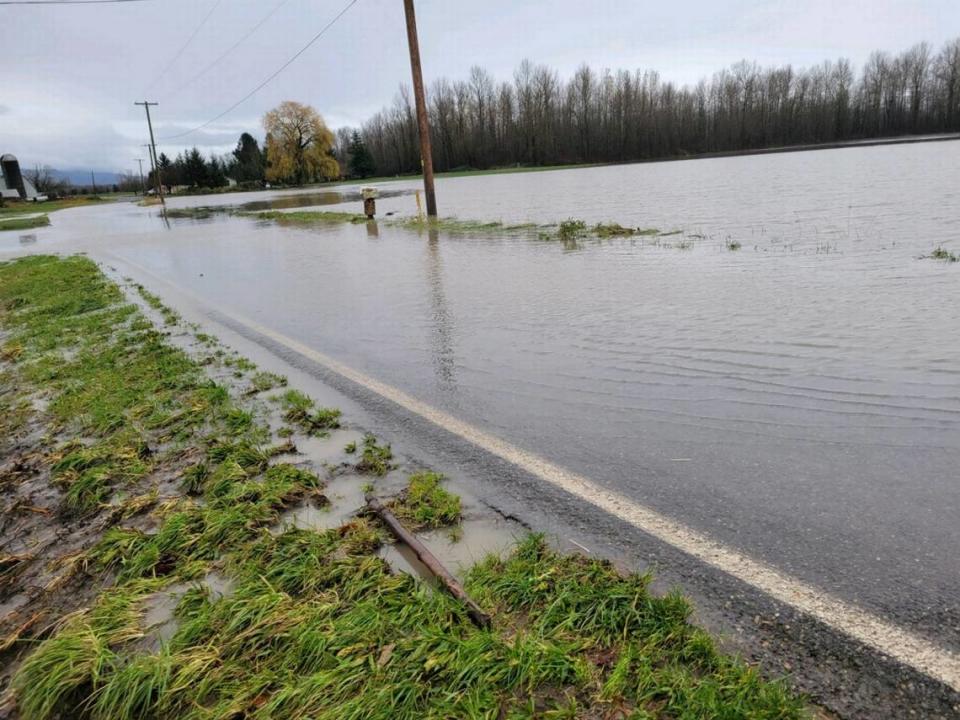
For the second time in two weeks, floodwaters from the storm-swollen Nooksack River have begun spilling into communities in northern Whatcom County.
Floodwaters from the Nooksack River began flowing into Everson Sunday afternoon, Nov. 28, after more than 24 hours of rain from the latest November “atomospheric river” to pass through Whatcom County, according to a release from the Whatcom County Sheriff’s Office.
Whatcom County Public Works is monitoring the floodwater as it moves towards Sumas, according to the release.
Shortly after 3 p.m., the City of Sumas announced in a Facebook post that it had sounded the flood alert after floodwaters had passed Main Street in Everson.
“We just sounded the flood siren in Sumas because the Nooksack River has come over the bank in Everson and is going across Main Street,” the post made at 3:17 p.m. read. “As a reminder, there might only be a short amount of time before the roads going in and out of Sumas could be closed due to high water. After that point, it will be safer to shelter in place. Please make any necessary preparations now.”
The National Weather Service issued a flood warning for Everson and Sumas at 3:06 p.m. due to the Nooksack overflow.
“The water level will stay lower than the flood two weeks ago, but it is still flooded from last time,” the National Weather Service said in a tweet.
The National Weather Service also tweeted that the atmospheric river began to “give out” Sunday afternoon, turning to scattered showers.
An emergency alert advising Sumas and Everson residents to voluntarily evacuate Saturday night, Nov. 27, was sent out shortly before 6 p.m. as rain continued to fall in Whatcom County.
“Life safety is our primary concern. Road closures begin as early as 4 a.m. Sunday,” the flooding alert read.
The recommended evacuation area was for Everson and Nooksack residents impacted by the “Super Bowl” flood of 2020 and anyone in Sumas, according to Sunday’s release. It remained in effect as of Sunday evening.
News that the river had flooded Main Street in Everson was expected, as Everson Mayor John Perry earlier Sunday afternoon reported on Facebook that the Nooksack River had topped Emerson Road and is now heading toward Main Street in Everson.
“We anticipated it reaching East Main Street around 3 p.m.,” Perry wrote in a Facebook post made shortly before 2 p.m. “Expect East Main Street to be closed between Blair Drive and Highway 9 sometime between 3 and 4 this afternoon.”
Despite that news, Perry said the forecast for the Nooksack has not changed.
“It is still expected to crest at Cedarville around 10 p.m.,” Perry wrote. “The river should crest in Everson around midnight if the projections don’t change.”
As of 5:15 p.m., Perry said that floodwater had reached Van Buren Road south of Tom Road, but that water levels were not rising particularly fast.
“PSE has no plans to shut off power at this point. They will call us if that changes,” Perry wrote.
Flood preparations
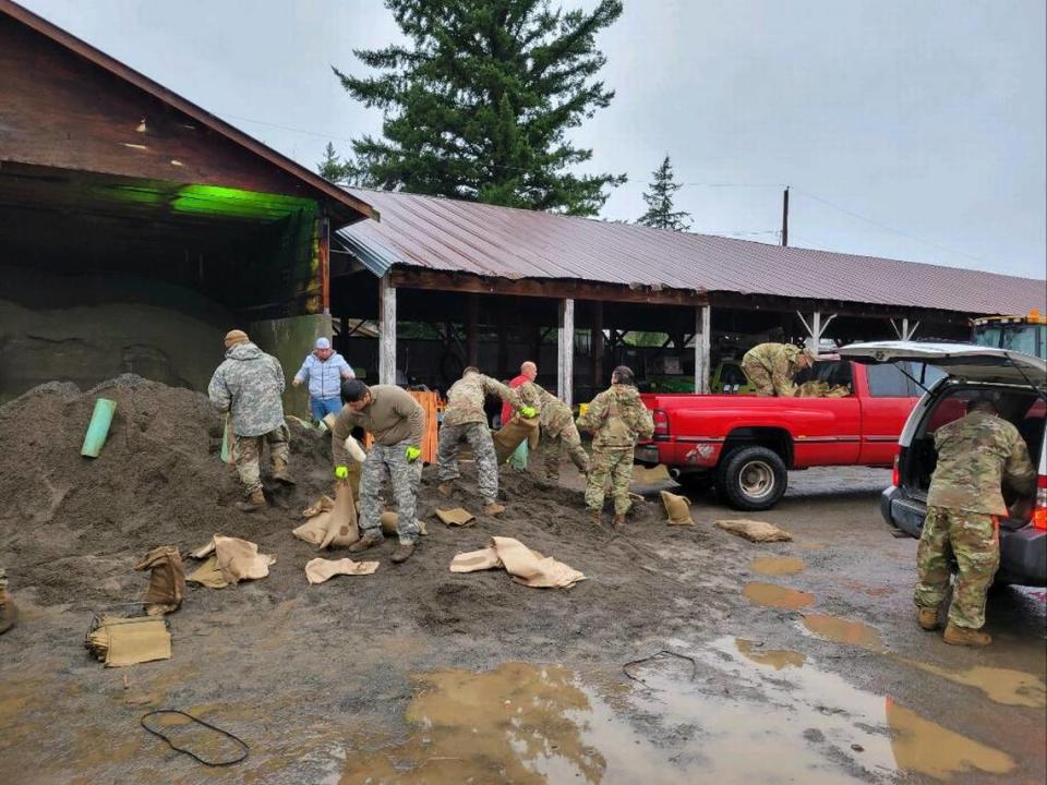
Members of the National Guard have been stationed in Everson and Sumas, according to Sunday’s release, and they have been working to fill and deliver sandbags and provide community assistance where needed.
The sheriff’s office’s search and rescue personnel have also been pre-staged in the event they are needed to make water rescues, according to the release.
“River flood models continue to fluctuate,” the release states. “Current predictions show the river cresting at Cedarville around 10 p.m. tonight (Sunday), and cresting at Ferndale around 10 a.m. on Monday, Nov. 29. There is much uncertainty with how changes to the river channel, damages to the levee system and depleted floodplain storage may impact the flooding that results from this storm.“
Shelters are available for those displaced by the flooding, according to the release, with a 24-hour, 7-day-a-week shelter at the Mount Baker Rotary building (1775 Front Street, Lynden) and one open from 5 p.m. Sunday to 8 a.m. Monday, Nov. 29, at Christ Lutheran Church (5904 Vista Dr., Ferndale).
But even those who have not been displaced by floodwaters should be aware of the dangers posed by the latest storm, according to the release.
“In addition to river flooding, the county is experiencing significant standing water and ponding issues that are affecting roadways, and in some cases, homes and other buildings,” the release states. “The soil is saturated. Water retention ponds, culverts, and ditches are full or overflowing. These conditions also increase the likelihood of landslides.”
The City of Bellingham reported that it measured two inches of rainfall between midnight and 7 a.m. Sunday at the Post Point treatment facility with more anticipated.
Before midnight Sunday, the National Weather Service reported Bellingham has seen 11.64 inches of rain so far in November — an all-time record for the month.
Previous flooding
The areas that are now likely to flood were inundated as the Nooksack River surged over its banks on Nov. 14.
Damages from that flooding could reach as high as $50 million, Whatcom County officials said at an online briefing Nov. 23.
John Gargett, deputy director of the Whatcom County Sheriff’s Office Division of Emergency Management, said he wouldn’t be surprised if public and private damages and economic losses reach that mark.
Included among that $50 million, Gargett said, were estimates of $15 to $20 million in damage to houses in the area, “tens of millions of dollars” in damage to public infrastructure and another $15 to $20 million in damage to area business centers.
The next storm
Unfortnately, it looks like Whatcom County isn’t free from these repeated rounds of soaking storms, yet.
As of Sunday, morning, the National Weather Service is predicting another system to bring a third round of persistent rain to the region Tuesday and Wednesday, Nov. 30 through Dec. 1.
Snow levels with the storm are expected to rise to 9,000 to 10,000 feet again, and “overall rainfall amounts now look similar compared to the weekend’s system,” the National Weather Service said.
It is uncertain how area rivers will respond to the additional rainfall, “however, given saturated soils, the potential for new or continued flooding is increasing,” the forecast read.
Threats for landslides also will increase, giving the saturate soils and with periods of heavy rainfall and wind from the system acting as triggers.
Gusty winds are also expected once gain, before the rain is expected to taper Thursday and give way to drier, cooler weather.

