What's planned for Lake Springfield? Here's what to know about the city's latest plans
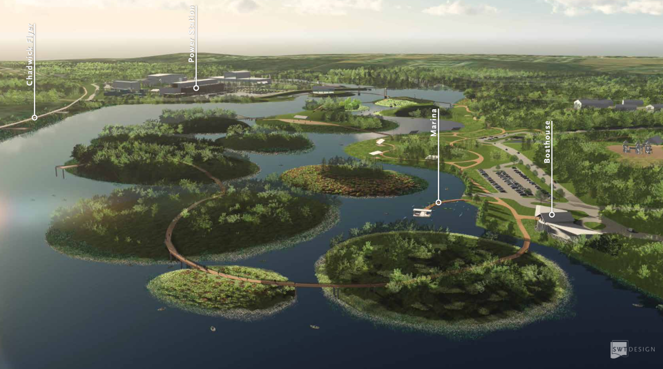
Innovative wetland ecology islands, an entertainment center and an adventure park are only a sliver of the possible features being considered as part of a planned revamp of the Lake Springfield area.
After numerous public engagements, water assessments and economic impact studies, the enhancement plan is nearing completion. Thursday evening, Steve Prange, project manager with Crawford, Murphy and Tilly, the engineering and consulting firm selected as the consultant for the project, updated the public on the draft plan, findings and recommended next steps. The meeting was the third and final meeting of its kind.
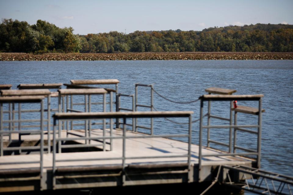
The plan covers the redevelopment of approximately 1,000 acres owned by City Utilities in the Lake Springfield area and will complement the Lake Springfield Boathouse and Marina that is already operated jointly by City Utilities and the Springfield-Greene County Park Board and is the city's largest park. The area was identified in particular as a place for economic opportunity in the Forward SGF Comprehensive Plan.
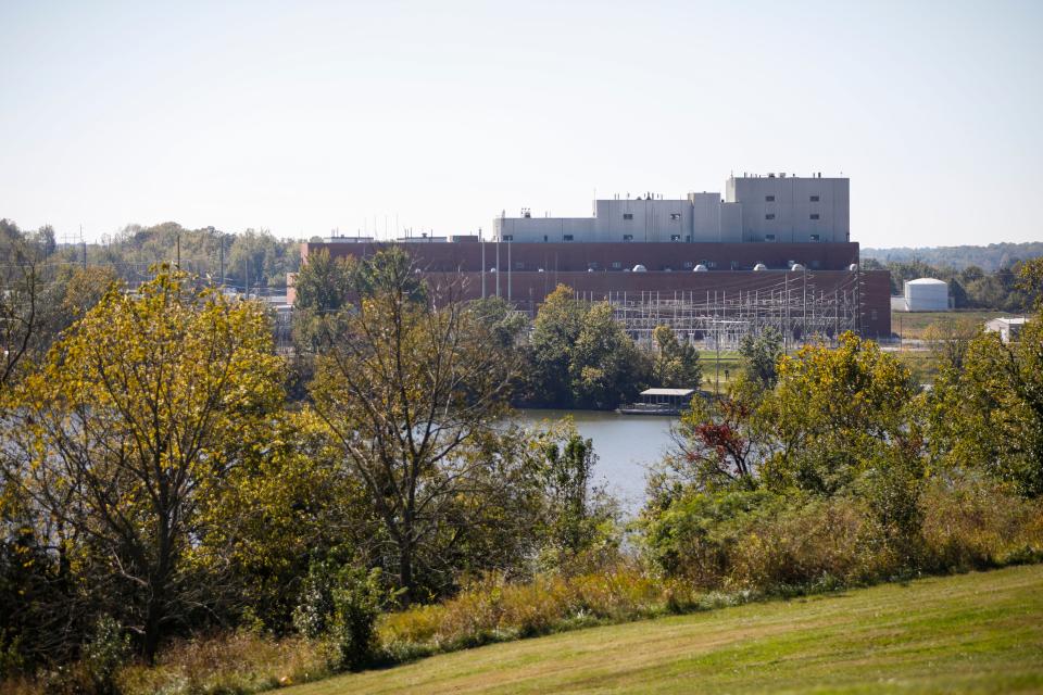
The lake was created in 1957 by damming James River in southeast Springfield to serve the cooling needs of the James River Power Station. The plant was decommissioned in early 2021, though the facility continues to be used by City Utilities to operate a vital substation that provides the surrounding community with power. Relocating the substation would be costly and its importance to the electric grid means it needs to remain, although other parts of the plant can be phased out to allow room for development.
The plan was created with input from more than 1,000 residents and various intersectional focus groups including different identities and abilities.
Honoring native land
The redevelopment of the northernmost part of the lake, near the intersection of Highway 60 and Highway 65, is focused on extending access and connectivity to nature. Prange said the plans here focus on creating more access points to the James River and on conserving and preserving the wetlands.
The current park area near the lake would be entirely revamped under the plan, Prange said. Development of a cultural education center was proposed after partnership with a Missouri State University senior design class in planning revealed this as a desired amenity. Prange said the work of the facility would be done in partnership with local Native American populations and organizations with ties to the land and the watershed. The boathouse could be expanded to be two or three times as large and include a dedicated marina with kayaks and canoes for visitors to rent.
Randy Falcon is the cultural coordinator at the Southwest Missouri Indian Center, which serves 42 counties in southwest Missouri through food outreach, education, youth enrichment and advocacy. Falcon was among those Prange and the planners met with to learn about the history of the land and how it could be honored in the future. Through the proposed culture center and the lake at large, he said he hopes this can be a way for the local Natives to become more visible in Springfield's daily life in a way that is not performative with teepees, garments and dances but educational, sharing cultural practices.
"We're not in the public's eye, this gives us a chance to be there and kind of educate people a little bit more that we're here," Falcon said.
When concerns about the water clarity and quality were brought up by the audience at Thursday's meeting, Falcon shared a practice of growing and harvesting wild rice in the water. This is a way both to improve the water as well as provide the Native population with a resource. He said if visitors see them harvesting the rice in the canoes they would be able to learn about the practice. Some Osage tribal members also would be willing to donate green houses to the project to grow food and medicinal plants and educate visitors on the native plants.
"Then kids can learn this was the actual plants that were here, not something that was man-made or brought in from another country," Falcon said. "This is what Osage people used because this is their property, this is their land."
During the meeting, Falcon raised concerns about preserving burial mounds on the property. He said historically some tribes were kept in the area before being moved to Oklahoma and mounds have been noticed toward the southern part of the project area.
Prange said the consultants, in partnership with MSU, had done extensive research and had not found any documented record of culturally-sensitive sites in the area. He also said that not a lot will be done with the portion Falcon pointed out near the landfill. Falcon said Prange has assured him that if they run into anything as work begins, they will preserve, protect and connect with him.
Northern shore of lake: "World class" park experience, greater access
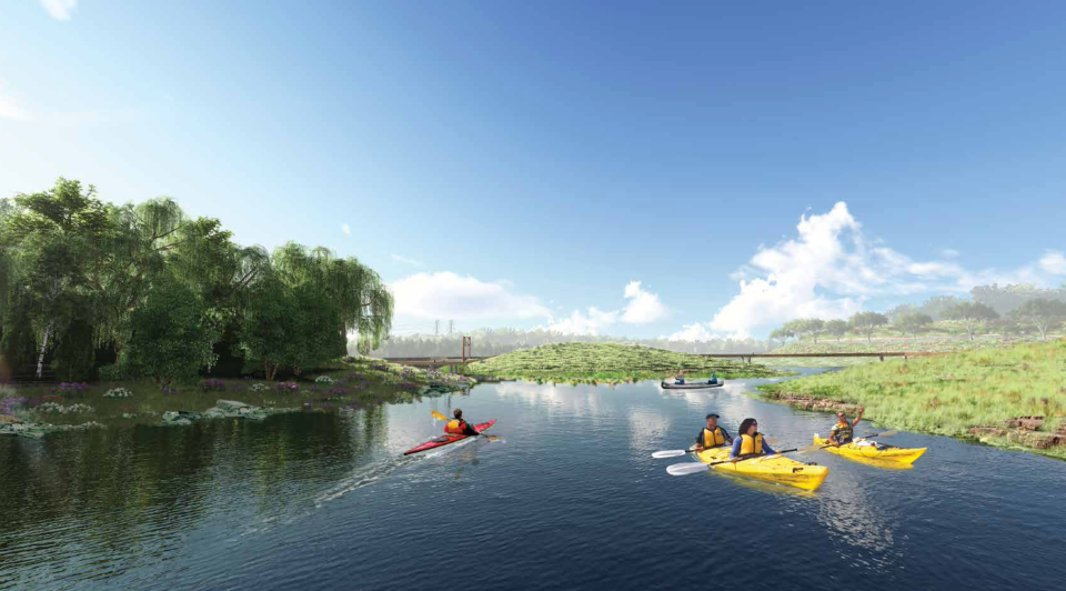
One of the most innovative aspects of the new plan is the proposed installation of wetland ecology islands on the lake by the park bank and a boardwalk above the water to bring people of all abilities closer to the water than is currently possible.
"This will be a world class, very unique experience for Springfield and the country where you'll have elevated boardwalks and trails, about three miles of that stretch all the way through these islands on piers so people can kind of get out onto the water, enjoy the water environment, without getting into the water," Prange said.
The boardwalks will also include outlooks for fishing, opportunities for which are currently very limited.
"This eco island concept is a huge water quality benefit for the whole area, and it stems aquatic life, plant life, gives the plants a place to really feed that oxygen into the water source," Prange said. "Just an awesome enhancement while we maintain the integrity of the lake. So, we're really excited about this vision and this part of the plan."
Through surveys, Prange said they also found that crossing the lake is currently very limited. The proposal for the park area also includes a pedestrian bridge across the skinniest part of the lake connecting the park to the new Chadwick Flyer Trail. The Chadwick Flyer Trail is a project headed by the Ozark Greenways that will be 12 miles long and connect the Ozark Community Center in Christian County to downtown Springfield.
More: New Chadwick Flyer Trail, expected to cost $20M, coming in next 5-10 years
South side of the lake: Entertainment district or adventure hub
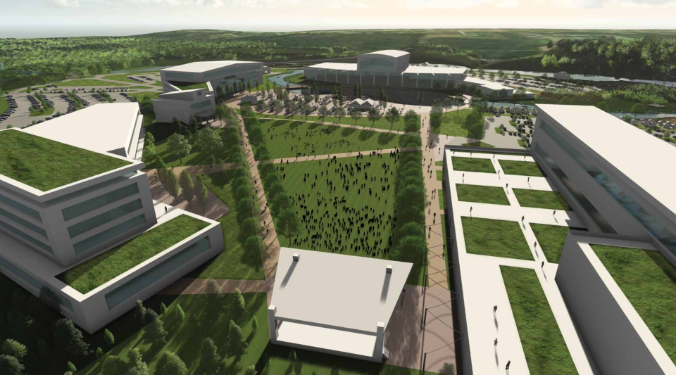
While the north portion of the area only has one option for developments, the plans offer two different use plans for the site of the former power plant and the southernmost activity area.
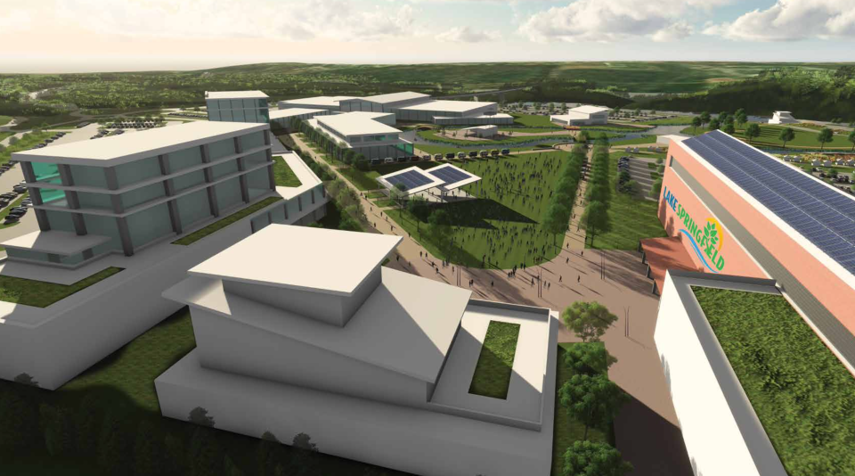
The first concept proposes an entertainment district in the power plant's place, complete with a multi-use event venue, restaurants, space for retail, residential and office space and possibilities for riverfront recreation and whitewater adventure. The Chadwick Flyer trail would feed into making the entire development accessible to pedestrians.
This option is coupled with an eco retreat center proposed for the south activity area of the project. This would include space for cabins, camping, RVs, a bike park and adventure courses. A man-made lake area is also proposed for the retreat plan that would allow visitors to get in the water. With this concept, the goal is to extend Lake Springfield as a place that has it all, from lodging to entertainment to nature preservation.
The second concept instead proposes an adventure hub for the power plant site which includes restaurants, a conference center, kayak basin and a water adventure facility. This would be paired with a destination adventure park in the south activity lot with space for RVs and a bike park. It would also include an amphitheater, ropes courses, archery and adventure activity lake. Prange said demand for RV and camping space has been on the rise in Springfield in particular.
"This is again more about embracing who we are in the Ozarks and attracting not only an amenity for our locals to enjoy but to attract other people to come to our community and spend some time, spend their money and really enjoy who we are and what we treasure," he said.
Both plans present the option of adding a water bypass that could connect Lake Springfield to James River downstream, whcih the dam currently separates. Prange said this would allow both wildlife and recreational boaters to pass through.
"We do have a unique opportunity with the James to create one of the world's largest water trails," he said. The creation of the bypass would connect Lake Springfield to Lake Taneycomo through the James River. "It could be a huge national draw to experience something like that during high flow events."
The creation of the bypass is estimated to cost about $7 million. It would require the lake's elevation to be lowered down by two feet and leave less water in the lake, which would result in little islands forming in the shallowest parts near the park area. The installation of the ecology islands would take advantage of this.
The landfill on the southwest part of the area will be left alone.
Since the power substation would remain in the vicinity for some time, it would be surrounded by uses for development like parking lots and roadways and most of the development would be located away from it. Prange said the power plant site would likely be the last phase to be developed though it would also be the grandest in its impact, calling it the "knuckle" of the entire 1,000 acres.
Expected economic impact
Currently, funds to execute the various plans have not been secured. The full realization of every part of the area, no matter which option is selected, Prange said would come within 15-20 years. The earliest the park and south activity upgrades could be done is within ten years.
Both concepts would result in an estimated total development price tag of more than $1 billion. This price tag includes all the necessary infrastructure like utilities and roads. The entertainment center option is slightly more expensive, though it is also expected to result in a greater economic impact through room stays, taxes generated and direct visitor spending, according to the consultant's ten-year estimates. In total, the development is estimated to generate as much as about $200 million annually within ten years of operation.
Because funding is still undecided, there are a variety of options available, from federal grants to working with private developers. There are currently no tax dollars committed to the project, though this could be introduced later down the line.
The park and lake portion of the redevelopment plan is projected to cost approximately $114 million. This steep price may mean this portion also will depend on private funding, as the Park Board struggles to keep up financially with the uptick in demand for maintenance and creation of green spaces.
"What we heard from our city leaders in the parks department was 'We are really struggling to keep up and give our citizens the experience and the level of maintenance that they deserve with our existing system the way it is,'" Prange said. "So, they are embracing the fact that this could be transferred over to a private entity."
He said when it comes to any and all parts of the plan, no option for funding is off the table. Public-private partnership will be a major part of reimagining the area.
"We certainly have a nationally award-winning park system, we are not nationally award-winning funded," said city spokeswoman Cora Scott. "So that is a realistic challenge, given our current funding streams."
Scott said in previous public surveys, citizens have increasingly put more value in the park system and support investing more existing revenue in the parks and considering additional taxes to fund the system.
City Manager Jason Gage suggested to City Council last month that parks could be one of multiple beneficiaries of a 3/4-cent sales tax he proposed taking to voters in place of the current tax that funds the Police and Firefighters' Retirement System and is due to expire in 2025. At the time, City Council did not reach consensus on the ballot language for the potential tax, so the future of the initiative is still uncertain.
More: With pension sales tax due to expire, City Council considers taking new tax to voters
While nothing is set or promised, Scott said she does foresee at least some parts of the project being funded publicly.
The development of the master plan itself was funded through an $800,000 grant from the U.S. Department of Commerce’s Economic Development Administration and $200,000 from the Hatch Foundation, City Utilities of Springfield and the City of Springfield's Environmental Services Department. The plan is set to be adopted by City Council and the City Utilities Board by the end of this year or beginning of 2024 with implementation to follow.
Environmental studies come back clean
As part of putting together the plan, hydrological studies and surveys of the land were conducted.
Prange said the water quality in the lake is excellent, with the water ecosystem thriving with flora and fauna. The first six inches of the sediment at the bottom of the lake were tested for pollutants and came back clean as well.
Some attendees Thursday greeted the environmental assessment with skepticism. Prange said due to the presence of E. coli in the James River and the regional waters at large the water is not safe to swim in and not safe for the fish caught there to be consumed. An audience member pointed out that those canoeing or enjoying other recreational water activities would still come in contact with the water. Prange said this is something the regional partners focused on water quality must address at a larger scale.
The depth of the lake however, needs to be addressed to continue to remain a lake. Prange said over the years sediment, about 8,000 cubic yards per year, has moved into the lake and is slowly filling it up, leaving some areas less than four feet deep. If left as is, Prange said the lake is likely to fill in and turn into wetlands within 20-50 years.
The plan estimates restoring the depth of the lake to its "as built condition" would cost anywhere from $35-90 million. The eco islands will be a way to avoid this steep cost while still addressing the shallowness of the lake. Prange explained that the islands will be constructed using a specialized dredging technique, so no sediment actually leaves Lake Springfield.
Prange said environmental protection regulations have evolved significantly since the lake was created in 1955, so new developments have more requirements in place to control sediment runoff. As these plans are realized, he said the city would work with various regional entities like the James River Basin and the Watershed Committee of the Ozarks to stop sediment from continuing to fill the lake.
"We have to say, 'What can we do as a region?' because this problem doesn't start and end at Lake Springfield," Prange said. "The problem and the challenge is everything upstream."
Making the park more accessible
The dam that separates the lake from the James River was found to be in excellent shape. While options to eliminate it or replace portions of it were considered, these are costly and the condition of the dam means they're not necessary. Instead, long-term maintenance would cost about $2 million, 20-30 years from now.
The bridge above the dam, however, is not in same shape. While still safe, the bridge — which is one of the largest bridges in Springfield — will require significant work. One solution proposed would be to close it to vehicular traffic and leave it pedestrian-only. The bridge is currently a part of Kissick Road, which is the main route across Lake Springfield.
Prange said the public has expressed overwhelming support for closing the winding and hilly two-lane road.
The plan outlines options to address vehicular access to the area at large. While it can remain as is, a new southwest gateway road is an option to alleviate traffic from Kissick while still connecting to Highway 65 to provide ease of access for travelers and intercept travelers en route to Branson. The road would pass through the area parallel to Kissick, just south of the power plant location, and connect to the current Kissick and Evans Road interchange that feeds onto Highway 65.
More: Could Lake Springfield be an ecotourism destination? City, consultants continue to plan
Another option would be to utilize the proposed East/West Arterial, which Greene County has proposed to stretch from Cox Road on the west to Kissick on the east, including a bridge over the James River. The proposed road could serve as an access point to Lake Springfield and future developments as it would run through the southern portion of the area. The plan includes two options — one where Kissick remains as is through the park and has an exit entry onto this roadway and another where the road is closed.
"East/West Arterial is arguably probably one of the biggest transportation planning projects in Greene County," Prange said, though this would be a very expensive section of road.
He said the construction for any of the roads alone could take about five years to complete. The inner roads within the park would not be changed other than minor maintenance.
These plans are a collection of visions and desires the community has for the area but will be looked at by developers later on for feasibility and actual implementation. Not everyone in the audience was as supportive of the draft plans, with some asking "Why do anything?" But Prange said the members of the public surveyed or interviewed during the process overwhelmingly want something to be done with it and noted what is now an asset could turn into a problem if not addressed.
At its core, the project aims to respond to residents' desire for opportunities to embrace nature and address them in a bold and innovative way, he said.
"We need to start thinking differently, do something that will change our community," Prange said.
Marta Mieze covers local government at the News-Leader. Contact her with tips at mmieze@news-leader.com.
This article originally appeared on Springfield News-Leader: Lake Springfield could see entertainment district, adventure hub

