What's wrong with Lake Mead, summed up in a single chart
If there were a single chart that could sum up the problem at Lake Mead, this might be a contender:
OK, maybe not. Because a single chart should be self-explanatory.
This one requires some background.
But it says a lot about where we’re headed. And the shifting goalposts on the way down.
The solution: Tank Mead to save Powell
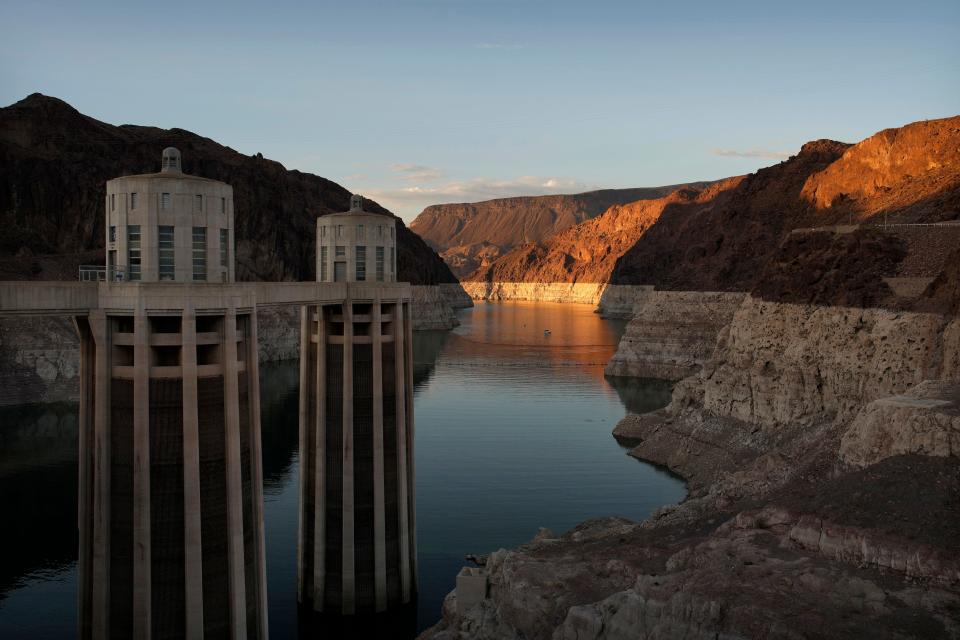
Lake Mead relies on inflow – mostly, water released from the upstream Lake Powell.
Until recently, Lake Mead typically would get at least 8.23 million acre-feet of water annually from Lake Powell – enough to cover the state of Maryland in more than a foot of water.
We began this year expecting to get a lower 7.48 million acre-feet release from Lake Powell. But the federal Bureau of Reclamation, for the first time, trimmed that mid-year to 7 million acre-feet because of how dangerously close Powell was to something called “minimum power pool.”
That’s the point where water is too low to flow through eight hydroelectric turbines and instead must flow through four smaller tubes at the base of the dam – tiny tubes, in comparison, that were never designed to flow millions of acre-feet of water, especially over time.
If anything were to fail – which bureau engineers are seriously worried about – it would vastly decrease the amount of water that could flow to Mead.
And that would tank Mead in a heartbeat, because significantly more water already flows out of Lake Mead to users than flows into it from upstream.
Even the best-case scenario isn't great
If we want water to keep flowing out of Powell to Mead, so it doesn’t tank Mead, we may have to cut even more deeply how much water flows to Mead from Powell … which also could tank Mead.
That brings us back to the chart, presented to the Arizona Reconsultation Committee during a meeting in which delegates discussed how the state should respond to this mess.
It shows three possible inflow futures:
The blue and red lines model what might happen if Lake Mead were to get 7 million acre-feet, plus varying inflows from the tributaries downstream of Powell.
You might call the blue line the best-case scenario, given the kind of runoff we’re forecast to get this winter. The red line may be closer to what’s most likely to happen, given how the 24-month studies off which these lines are based have played out in recent years.
Note that even in the best-case scenario, Lake Mead still drops below 1,020 feet of elevation by mid-2024 (more on the significance of that in a second).
The worst case puts us just above 'dead pool'
The green line, meanwhile, models what happens if Mead only gets 5.5 million acre-feet from Powell in 2023, plus a comparably “better” 6.5 million acre-feet in 2024.
Reclamation is studying such a scenario because our previous efforts to avoid that dangerous “minimum power pool” mark on Powell haven’t been enough to last.
A 5.5 million acre-feet release would plunge Lake Mead to just above 960 feet of elevation in 2024 – a mere 65 feet above “dead pool,” the point at which water could no longer flow past Hoover Dam.
That’s not much of a buffer, considering that 1,020 feet of elevation has long been the red line that Lake Mead simply could not cross. Interventions were modeled and actions were taken (including the 2019 Drought Contingency Plan) in hopes of avoiding this line.
That’s because many considered 1,020 feet the last buffer against a system crash. Fall below that point, the warning went, and the lake would never recover.
Yet all three forecasts suggest that if we don’t agree to cut more use – and a lot of it – we’ll cross that once-uncrossable line by the end of next year.
No matter what, we'll all use less water
It’s still possible to stall Lake Mead’s decline at around 1,020 feet.
Federal modeling suggests that if inflow is similar in 2023 to what we got in 2022, we’ll need to stop using an additional 2.5 million acre-feet of water, over and above the cuts to which we’ve already agreed, to stop Lake Mead from plunging past 1,020 feet.
Mind you, even if states somehow find (or Reclamation forces) 2 to 4 million acre-feet in cuts, a target based on that analysis, that simply keeps Lake Mead and Lake Powell from going any lower.
The buffers are gone. We’re living on the razor’s edge.
That’s what the chart tells me.
We’ve essentially drained the nation’s two largest reservoirs because, despite all our Band-Aids, use remains far greater than what the Colorado River can now produce.
We can finally do what it takes to keep the lakes functional, or we can lessen the pain, for now, and obliterate what little storage we have left.
No matter which future plays out, we’ll all use a lot less water.
Reach Allhands at joanna.allhands@arizonarepublic.com. On Twitter: @joannaallhands.
If you love this content (or love to hate it – hey, I won't judge), why not subscribe to get more?
This article originally appeared on Arizona Republic: Lake Mead's water problem, summed up in a single chart

