Where does the Mississippi River start, where is it deepest, answers to key questions about one of Wisconsin's most important waterways
Wisconsin has one of the world's most important bodies of water right next door.
Nope, we're not talking about Lake Michigan, or Lake Superior. We're talking about the Mississippi River.
The river runs more than 200 miles along Wisconsin's western border and continues through America's heartland. It provides habitat for hundreds of fish and wildlife species, charts the course of millions of tons of goods exported from the U.S. and has a rich cultural history, featured in many beloved books and songs.
It's facing big environmental challenges: nitrate and phosphorus pollution, forest loss, invasive species and prolonged and excessive flooding, to name a few. But it could also provide nature-based solutions to some of those problems, as scientists, politicians and citizens learn more about what can be done to protect it.
How much do you know about the Mississippi? You can brush up on the basics here.
Where does the Mississippi River start and finish?
The Mississippi River begins as a small, knee-deep river flowing out of Lake Itasca in northwestern Minnesota. At just 18 feet wide, it's easy to walk across.
More: The Mississippi River is central to America's story. Why doesn't it get more love?
It flows hundreds of miles across Minnesota, including through the Twin Cities, before it reaches the Wisconsin border. Then it heads south, running alongside major cities like St. Louis, Memphis and New Orleans.
The river ends about 100 miles downstream from New Orleans, where it empties into the Gulf of Mexico. It takes 90 days for a single drop of water to travel from the headwaters to the Gulf.
Mississippi River tributaries: Where does the Wisconsin River connect to the Mississippi?
The Wisconsin River — the state's longest river — meets the Mississippi near Prairie du Chien. Wyalusing State Park provides a view of the rivers' meeting point.
There are other, bigger rivers, known as tributaries, that flow into the Mississippi and add to its volume. Those include the Illinois, Missouri, Ohio, Arkansas and Red rivers.
Mississippi River map: How big is the Mississippi River basin?
The Mississippi River basin drains more than 40% of the continental U.S. In other words, any drop of rain or snow that falls across a large part of the country ends up in the Mississippi. It includes 31 states — some fully and some partially — and two Canadian provinces.
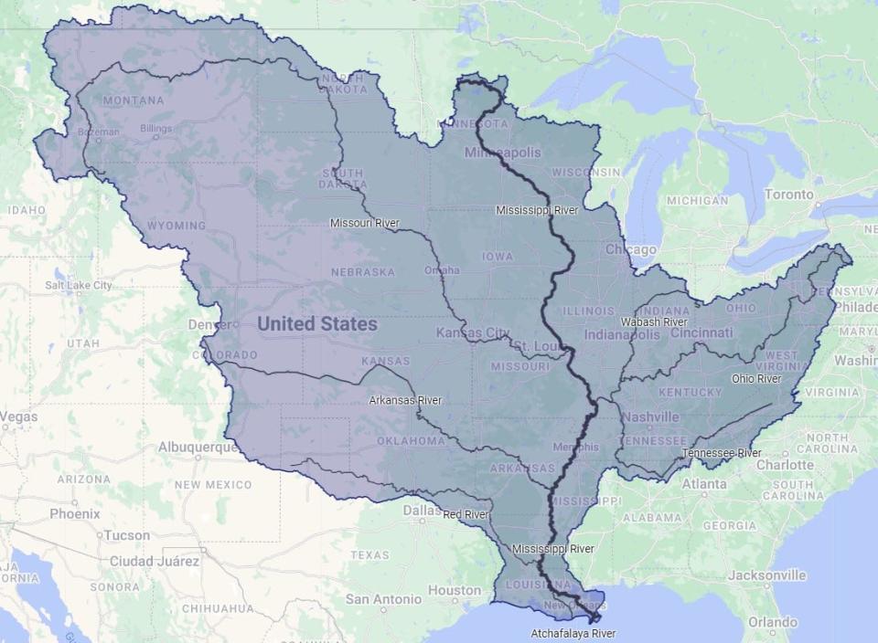
Most of the precipitation in the state of Wisconsin ends up in the Mississippi River. About 60% of Wisconsin residents live in the river basin. The rest of the state drains to Lakes Michigan or Superior.
Because water travels over so much land before it reaches the Mississippi River, land use is an important determinant of the river's health. Industry and agriculture have both played a role in polluting the river, resulting in what's known as the Dead Zone in the Gulf of Mexico — a massive area where nutrient pollution chokes off oxygen for fish and plants.
More: What is a watershed and why should you care?
Is the Mississippi River the longest river in the United States?
No. The Mississippi River flows about 2,350 miles, according to the National Park Service. The Missouri River flows about 100 miles longer, making it America's longest river.
The Missouri River stretches from the Rocky Mountains in southwest Montana to St. Louis, where it meets the Mississippi.
More: Mississippi River lock-and-dam system is outdated and in disrepair. What if it fails?
Both rivers' lengths can change slightly as their deltas grow or shrink from sedimentation or erosion. The Mississippi River delta in particular has lost approximately 70% of its land area since 1932 due to coastal erosion, sea level rise and human activities like oil and gas extraction.
Is the Mississippi River one of the longest rivers in the world? How does it compare to the Amazon and Nile?
Most lists of the world's longest rivers combine the Missouri and the Mississippi, since they join up. By that measure, the river is the fourth-longest in the world, behind the Nile, the Amazon and the Yangtze rivers.
By volume, the Mississippi River is the 15th-largest in the world. It discharges close to 600,000 cubic feet of water per second into the Gulf of Mexico, according to the National Park Service.
Where is the Mississippi River deepest?
The river's deepest point is near Algiers Point in New Orleans, measuring about 200 feet deep. That's a far cry from its depth at the headwaters, which is about 18 inches, according to the Minnesota Department of Natural Resources.
Do people drink from the Mississippi River?
Yes. The river provides drinking water for almost 20 million people in more than 50 municipalities, according to the environmental advocacy group American Rivers.
More: Climate change imperils the upper Mississippi River backwaters. Now nature needs human help.
People who live in the Twin Cities and surrounding suburbs, for example, get their drinking water from the Mississippi.
What cargo does it transport? Is the Mississippi River drying out?
The Mississippi River is a major player in worldwide shipping and commerce. It carries around 500 million short tons per year of goods, including corn, soy, fertilizer, road salt, coal and petroleum products.
More than 90% of the nation's agricultural exports are grown in the Mississippi River basin; 60% of all grain exported from the U.S. is shipped on the river.
Periods of drought or flooding — which are expected to get more frequent as the climate changes — can stall shipping on the river. For example, near-record low water levels caused by drought caused barges to run aground on the lower Mississippi in fall 2022.
More: As Mississippi River swings between historic highs and lows, shipping industry struggles to adapt

Is the Mississippi River important for wildlife?
The river ecosystem is vital for a wide variety of birds, fish and other animals. Each year, it provides a place to rest, breed and eat for more than 325 species of migrating birds. The upper Mississippi alone is home to over 119 species of fish, and its surrounding backwaters, wetlands and forests provide habitat for a multitude of other animals as well.
These important habitats are threatened by climate change and human activities. For example, prolonged and frequent flooding on the upper Mississippi caused by more precipitation and land use changes in the basin is killing floodplain forests and disturbing habitat for fish.
More: The Mississippi River's floodplain forests are dying. The race is on to bring them back.
How did the Mississippi River get its name?
"Mississippi" comes from the French interpretation of the Ojibwe name for the river. That name was Misi-Ziibi, which means "great river."
The river is known by a variety of nicknames too, such as the Father of Waters.
Have other questions about the Mississippi River? Email Madeline Heim at mheim@gannett.com. Heim is a Report for America corps reporter who writes about environmental issues in the Mississippi River watershed and across Wisconsin.
Please consider supporting journalism that informs our democracy with a tax-deductible gift to this reporting effort at jsonline.com/RFA or by check made out to The GroundTruth Project with subject line Report for America Milwaukee Journal Sentinel Campaign. Address: The GroundTruth Project, Lockbox Services, 9450 SW Gemini Dr, PMB 46837, Beaverton, Oregon 97008-7105.
This article originally appeared on Milwaukee Journal Sentinel: 10 important facts about Mississippi River: how long, tributaries, map

