Where is Hurricane Idalia now? When will it arrive in Florida? Here’s the forecast track
Idalia is expected to become a major hurricane Tuesday night before it reaches Florida’s Big Bend coast Wednesday morning.
It brings with it heavy rain, gusty winds and dangerous storm surge.
Nearly the entire Gulf Coast — along with Key West and the Lower Florida Keys — are under hurricane, tropical storm and storm surge watches and warnings.
Schools and airports have begun to announce closings ahead of Idalia’s expected arrival Wednesday. And some counties have already ordered mandatory evacuations.
What type of stormy weather will Idalia bring to the state? And when?
Here’s what the track shows:
Where is Idalia now? And how strong is it?
Hurricane Idalia, a Category 2 storm, was about 155 miles southwest of Tampa and about 245 miles south of Tallahassee on Tuesday night, according to the National Hurricane Center’s 8 p.m. advisory.
The storm, which is moving north at 16 mph, is on its way to Category 3-level strength, with maximum sustained winds of 105 mph. It needs maximum sustained winds of at least 111 mph to be a Cat 3.
Hurricane-force winds extend up to 25 miles from the center, with tropical-storm-force winds extending up to 160 miles.
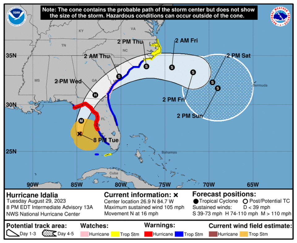
Where is Idalia going? How strong will it be?
Idalia is expected to move north to north-northeas Tuesday night, and its center is forecast to reach the Big Bend coast Wednesday morning with 115 mph winds. After landfall, the center of Idalia is forecast to turn toward the northeast and east-northeast, moving near or along the coasts of Georgia, South Carolina, and North Carolina late Wednesday and Thursday.
Because Idalia will be moving quickly, it’s possible it may remain a hurricane as it moves across the state and runs along southern Georgia toward South Carolina’s coast.
It should be a tropical storm by the time it’s back into the Atlantic Ocean Thursday.
READ MORE: Which part of Florida will see the ‘dirty side’ of Idalia and face the worst weather?
What type of weather will Idalia bring to Florida?
Forecasters expect the storm will bring hurricane and tropical storm-force winds, heavy rain, dangerous life-threatening storm surge, some possible tornadoes, and dangerous surf and rip current conditions along Florida’s Gulf Coast.
Tropical storm conditions began Tuesday in the Dry Tortugas, off the Keys, and in parts of Florida’s Gulf Coast that are under a tropical storm warning or hurricane warning. Hurricane conditions are expected within the hurricane warning area in Florida by Tuesday night or early Wednesday.
▪ Rain: Portions of Florida’s west coast, the Florida Panhandle, southeast Georgia and the eastern Carolinas are forecast to see 4 to 8 inches of rain through Thursday, with some areas possibly seeing up to 12 inches of rain, primarily near the storm’s expected landfall in northern Florida.
“Areas of flash, urban, and moderate river flooding, with locally considerable impacts, are expected across the Florida Big Bend, central Georgia and South Carolina, through eastern North Carolina later tonight into Thursday,” the hurricane center said.
▪ Storm Surge: Idalia is also forecast to bring life-threatening storm surge to Florida’s Gulf Coast, with some parts of the state expected to see up to 15 feet of surge, according to the hurricane center.

READ MORE: How much storm surge will Hurricane Idalia bring to Florida? See the risk by area
Idalia watches and warnings in Florida
Here’s what the National Hurricane Center says:
▪ Hurricane Warning: Middle of Longboat Key northward to Indian Pass, including Tampa Bay
▪ Hurricane Watch: Mouth of the St. Mary’s River to Edisto Beach, South Carolina
▪ Tropical Storm Warning: Dry Tortugas, Florida; Chokoloskee northward to the middle of Longboat Key; West of Indian Pass to Mexico Beach; Sebastian Inlet, Florida to South Santee River, South Carolina
▪ Tropical Storm Watch: Lower Florida Keys west of the west end of the Seven Mile Bridge; North of Surf City, North Carolina to the North Carolina/Virginia border; Pamlico and Albemarle Sounds
▪ Storm Surge Watch: Englewood northward to Indian Pass, including Tampa Bay
Miami Herald staff writer Omar Rodríguez Ortiz contributed to this report.

