Where is Tropical Storm Fred going and will it come to Florida? What the forecast says
Forecasters are closely monitoring Tropical Storm Fred as it moves through the Caribbean Sea.
Fred is forecast to move near or over the Dominican Republic and Haiti soon. Cuba and Florida are also in its forecast track, but there’s still some uncertainty on Fred’s path and how strong it will be, according to the National Hurricane Center.
Forecasters will have a better idea of Fred’s potential impacts after it interacts with Hispaniola’s rocky terrain Wednesday.
Here’s what to know about the expected path so far:
Where is Tropical Storm Fred now? How strong is it?
Tropical Storm Fred was quickly moving west-northwest in the Caribbean Sea with maximum sustained winds near 45 mph, according to the hurricane center’s advisory at 11 a.m. Wednesday. The storm was about 25 miles south-southeast of Santo Domingo in the Dominican Republic.
Where is Fred going?
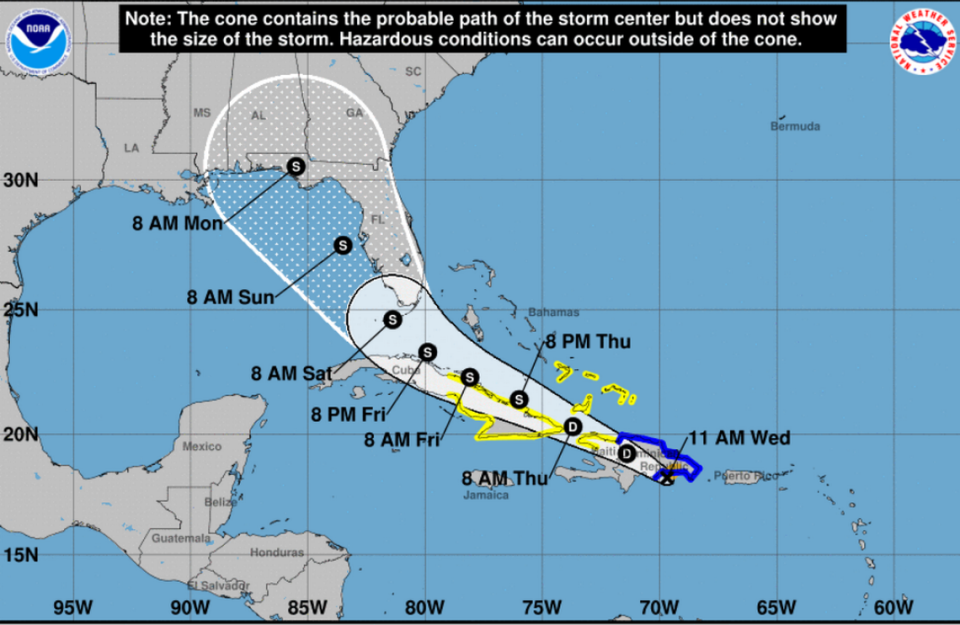
Fred is forecast to be near or over Hispaniola Wednesday, where it could weaken into a tropical depression. The system is then expected to move near the Turks and Caicos Islands and the southeastern Bahamas on Thursday.
Forecasters predict Fred will regain its tropical storm strength by the time it nears Cuba and Florida. Based on its forecast track, Fred should be near or north of Cuba’s northern coast on Friday and near Florida either late Friday or early Saturday.
However, there’s still some uncertainty over its track and intensity, according to the hurricane center.
What type of weather will Fred bring South Florida and the rest of the state?
While most of Florida is within Fred’s cone, it’s too soon to say what the storm’s impact will be in the state, according to hurricane center.
What forecasters know is that Florida will likely see some wind and heavy rain starting Friday night through the weekend or Monday.
Miami-Dade, Broward and Palm Beach counties could possibly see between 4 to 6 inches of rain, the weather service said.
Aug 11 @ 215am - One possible hazard from Tropical Storm #Fred is heavy rain. While these amounts may change here's a preliminary look at *potential* rainfall for Friday into this weekend. #flwx pic.twitter.com/Fb8cQGca2t
— NWS Miami (@NWSMiami) August 11, 2021
In the Florida Keys, isolated and scattered thunderstorms, with possible cloud to surface lightning strikes and damaging winds, will be possible Thursday night through Saturday night, according to the weather service in Key West. The bad weather is associated with Tropical Storm Fred.
Forecasters say the island chain could see between three to five inches of rain Friday through Sunday. Hazardous marine conditions and tropical storm conditions may also be possible Friday and Saturday.
Fred Watches/Warnings
A tropical storm warning is in effect for:
▪ The Dominican Republic on the south coast from Punta Palenque eastward and on the north coast from the Dominican Republic/Haiti border eastward
A tropical storm watch is in effect for:
▪ Haiti from the northern border with the Dominican Republic to Gonaives, the Turks and Caicos Islands and the Southeastern Bahamas.
▪ Parts of Cuba including the provinces of Ciego de Avila, Camaguey, Las Tunas, Holguin, Granma, Santiago de Cuba, and Guantanamo.

