Where's the snow? Milwaukee is nearly 15 inches below its average this season; 3 rounds of light snow are coming for the weekend
As far as snow goes in Milwaukee this winter, the haters have to be loving it.
Milwaukee is 14.5 inches behind its average snowfall for the season, and while light snow is forecast for much of the weekend and into Monday, it won't be enough to make up the deficit.
"We've got some catching up to do," said Andy Boxell, a meteorologist with the National Weather Service. "We're well behind in terms of snowfall and just overall liquid equivalent precipitation."
Milwaukee has seen only 7.7 inches of snow so far this season. That's about a third of where we ought to be for Milwaukee by this point in the season.
"Of course, all it takes is one or two good (storm) systems or a good lake effect (snow) band and we can make up that ground real quick," Boxell said. "But we're definitely behind."
That's not the case in other parts of the state. The Green Bay area is right on its average of 26 inches of snow by this point in the season. Appleton is within 0.8 inches of its average, Marshfield is 5 inches above its average and Wausau is nearly 7 inches above its average for this time of year.
More: Do a lot of people in Wisconsin hate snow, or does it just seem that way? It's complicated.
The lack of snow in southern Wisconsin is adding to drought conditions that were already in place across that region of the state.
Milwaukee finished 2021 with a moisture deficit of 10.44 inches. So far, 2022 has followed 2021's lead. The area is already nearly an inch shy of moisture for the new year.
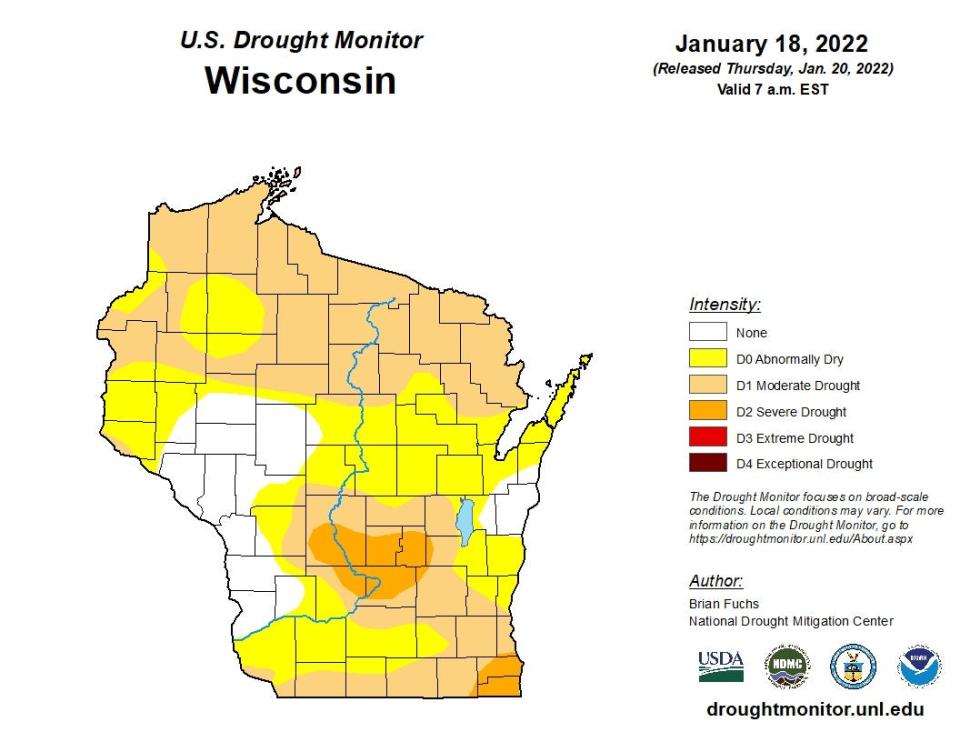
"We're definitely in a drought for sure," Boxell said.
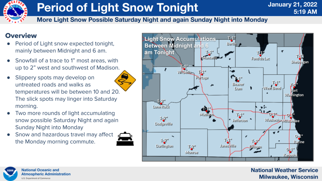
Three rounds of snow on the way for weekend
Three rounds of light snow are forecast across portions of southern Wisconsin from Friday night through Monday, according to the weather service. The snow will be light, and at least one of the snowfalls is likely to miss Milwaukee altogether, so the snow deficit will remain.
Round one. Light snow is expected across Wisconsin late Friday night and continuing into early Saturday morning, mainly between midnight and 6 a.m. As far as accumulation, a trace to a half-inch is expected in most areas of southern Wisconsin, according to the weather service.
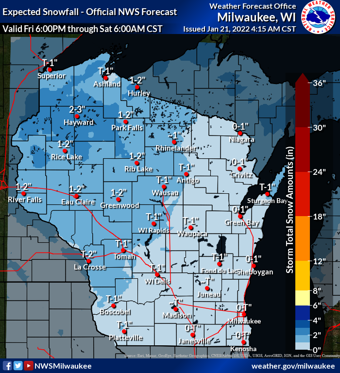
"That one really should not add up to much at all," Boxell said.
Round two. The second batch of snow looks to arrive between 9 p.m. Saturday and 6 a.m. Sunday. This round may miss Milwaukee completely.
"That one right now looks like it is going to be focused more to the southwest, roughly southwest of a line from Burlington to Madison," Boxell said.
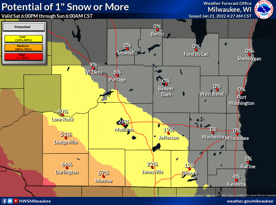
As for accumulation, "maybe 2 inches at the most," Boxell said. "We don't really see that one getting too much stronger than that."
Round three. This one is also expected to arrive during the overnight hours. Snow is possible from midnight Sunday night through noon Monday.
"Right now, it's kind of lining up to be a 1 to 3 inch (snowfall) with the highest snow totals north of I-94," said Paul Collar, a weather service meteorologist in Sullivan. "The Monday morning commute could be impacted.
"Of all these (three) little clipper systems coming through, that one looks like it will have the most punch to it," Collar added.
There remains uncertainty about where the most snow falls with the Sunday-into-Monday system, and the forecast for that snowfall will likely come into more focus in the next 24 hours or so, Collar said.
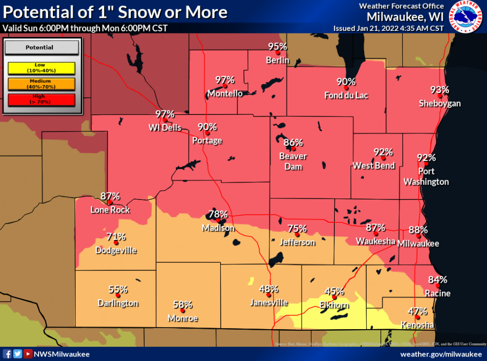
"I think there is certainly better than even odds that everyone will see some snow with that" Sunday-into-Monday system, Boxell said. "But as far as exact amounts, it's too early," to forecast that.
Bitter cold is set to return to the state next week after that Sunday-Monday system moves through.
"Very cold air will build into (southern Wisconsin) behind the Monday system, with Tuesday and Wednesday featuring some of the coldest temperatures of the season thus far," the weather service said in a statement. "Highs Tuesday and Wednesday will likely only reach the single digits, with lows well below zero, especially Tuesday night/ Wednesday morning."
The low in Milwaukee on Tuesday night is set to hit minus 2, with minus 5 in Waukesha, minus 10 in Madison, minus 16 in Wausau and minus 18 in Eau Claire.
Contact Joe Taschler at (414) 224-2554 or jtaschler@gannett.com. Follow him on Twitter at @JoeTaschler or Facebook at facebook.com/joe.taschler.1.
Our subscribers make this reporting possible. Please consider supporting local journalism by subscribing to the Journal Sentinel at jsonline.com/deal.
DOWNLOAD THE APP: Get the latest news, sports and more
This article originally appeared on Milwaukee Journal Sentinel: Milwaukee snow: There should be a lot more of it around here by now

