Where's the snow? Winter so far turns map upside down


 |
A truck treats the ice on the Atlantic Beach bridge after a winter storm hit North Carolina in Morehead City, N.C. on Saturday, Jan. 22, 2022. A layer of ice and a blanket of snow has covered coastal areas stretching from South Carolina to Virginia. The winter weather system that entered the region on Friday brought colder temperatures and precipitation not often seen in the region. (AP Photo/Tom Copeland) |
Plenty of chances for snow have come and gone so far this winter, but the wealth of snow has certainly not been spread evenly. As of Jan. 27, 2022, some cities in the central and eastern United States have seen their fair share, with near or above-normal snowfall, while other locales, some just a short distance away, are lagging well behind. Some of the usual cities near the top of the snowfall charts are nowhere to be found so far this year, giving way for some other unusual names to join the list.
Ahead of a huge winter storm that will sweep into the Northeast and change some of the numbers, AccuWeather meteorologists break down some of the surprising stats of where snow has and has not made frequent visits this season.
Buffalo and Syracuse, New York, along with Erie, Pennsylvania, are usually similar in terms of blockbuster winter snowfall totals. All three average close to or around 100 inches of snow every winter. However, only one of those cities is even close to on pace this season. Buffalo has tallied 62.8 inches of snow so far this season, compared to an average of 57.5 inches normally by this time in January. Syracuse is at about 35 inches, nearly 30 inches below average up to this point in the season. Erie has received just over 40 inches of snow, but even that is almost 2 feet below its average through Jan. 27.
 |
"Clipper systems, which often bring a general accumulating snow across the Great Lakes, followed by bursts of lake-effect snow, have been fewer than typical earlier this winter," said AccuWeather Senior Meteorologist Alex Sosnowski. "By mid-January, this changed, with Arctic air driving southeastward and more clippers bringing more snow and lake-effect opportunities for the interior Northeast. However, the average wind flow thus far has favored Buffalo getting heavier lake-effect snow than Syracuse and Erie so far."
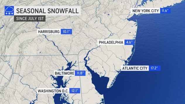
These cities in the eastern Great Lakes aren't alone in the oddities over short distances. Atlantic City, New Jersey, has picked up 17.2 inches of snow so far this season. Meanwhile, just 50 miles away in Philadelphia, only 4.6 inches of snow has been tallied this season. Typically, the relatively mild ocean waters would keep snow totals lower at coastal locations than inland places. Although by today, Philadelphia should have had 9.6 inches and Atlantic City 8.2 inches, by the end of the average winter season, that disparity increases with 19.3 and 13.5 inches, respectively.
Farther south, Washington, D.C., is on pace to have one of its snowiest winters in years, having recorded 12.1 inches already. Just two years ago, during the winter of 2019-2020, D.C. recorded its third-least-snowiest winter on record, tallying just 0.6 of an inch over the entire season. This winter, D.C. is on pace to rival some of the snowier winters of 2013 to 2016.
Part of the reason for this has been a shift this winter in the large-scale storm track. "The pattern in the jet stream, which is an area of fast-moving winds in the upper portions of the atmosphere that helps direct weather systems, has largely prevented storms that form over the South from turning northward along the mid-Atlantic so far this winter," Sosnowski said.
This pattern has also brought snow much farther south than just Washington, D.C., and Baltimore. Nashville, Tennessee, has picked up 9.3 inches of snow so far this season, well above the normal 2 inches for this time in January, and in fact, surpassing the city's average of 8.4 inches for an entire season.
Even more surprising to residents of "Music City" might be that Nashville has been snowier this winter than many major cities in the Midwest and Northeast. New York City; Columbus, Ohio; and Springfield, Illinois; are all behind Nashville's seasonal snow total so far this winter along with places farther to the west, like Kansas City, Missouri; Colorado Springs, Colorado; and even Pierre, South Dakota.
Some parts of the Midwest are in the midst of an impressive snow drought. Indianapolis has received only 1.2 inches of snow this winter, compared to an average of 15.1 inches. Columbia, South Carolina, has received more snow than Indianapolis, thanks to the 2 inches measured there on Jan. 21.
 |
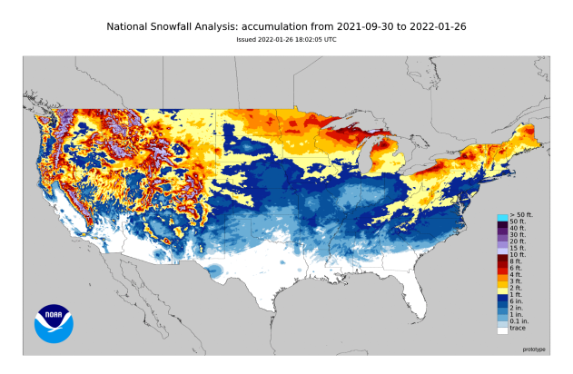
A map showing snowfall across the continental U.S. from Sep. 30, 2021, to Jan. 26, 2022. (NOAA) |
"Because the jet stream has been situated farther south than usual during much of January, Arctic air has also been allowed to make more frequent trips to the Southern states and deliver heavy snow to more areas that don't typically receive very much," Sosnowski said. Even Little Rock, Arkansas, and Birmingham, Alabama, have seen 0.6 of an inch of snow so far this winter.
While many more cities are running a big deficit than those seeing unusually high departures from normal for snowfall, the story of a snow drought is not true everywhere. Grand Forks and Fargo, North Dakota, are both running ahead of schedule with 11.0 and 10.1 inches more than normal, and Sault Saint Marie, Michigan, is more than 20 inches above normal for this time of year.
January may come to a close with many still asking, "Where's the snow?" - but winter is still far from over, and undoubtedly there will be more winter storms to get through and more chances to erase snow droughts and deficits before putting a wrap on the 2021-2022 winter totals.
For the latest weather news check back on AccuWeather.com. Watch the AccuWeather Network on DIRECTV, Frontier, Spectrum, fuboTV, Philo, and Verizon Fios. AccuWeather Now is now available on your preferred streaming platform.
