Why Atlantic hurricane development is different in October


 |
Hurricane Michael made landfall near Mexico Beach, Florida, on Oct. 10, 2018. |
The change of seasons from summer to autumn across North America is notable for crisp air, colorful fall foliage and, for some, the return of wintry precipitation. However, the fall season, and October in particular, is still a busy time of year for meteorologists scouring the tropics.
October is not only a very active month in terms of tropical activity, but it usually results in a shift in where most tropical cyclones develop across the Atlantic.
"While it's getting cooler across the United States and North America, water temperatures are still very warm. And that's why you can see tropical storms and hurricanes right into late October," said AccuWeather Chief Broadcast Meteorologist Bernie Rayno.
Bodies of water have the ability to warm and cool slower than land masses, allowing locations like the Gulf of Mexico, Caribbean Sea and the Atlantic Ocean to hold on to summer's heat a little longer than the land. This, in part, is the reason that the peak of hurricane season is Sept. 10, rather than during the typical "heat of summer" in July or early August.
 |
The warmth the large bodies of water can hold is what meteorologists call "ocean heat content," and it is essential to the formation of tropical storms and hurricanes.
CLICK HERE FOR THE FREE ACCUWEATHER APP
"As the seasons change and we get into October, the number of hurricanes that form in the center of the Atlantic typically starts to decline, and we become more concerned about areas in the Caribbean, Gulf of Mexico and western Atlantic," said AccuWeather Senior Meteorologist Alex Sosnowski.
Sosnowski explained that a combination of increased wind shear, or disruptive winds, over the Atlantic Ocean and the warmer waters elsewhere in the basin are key factors in the shift in tropical activity.
 |
On average, October ranks third behind September and August for months with the most named tropical systems in the Atlantic basin. In recent years, some of the strongest and most impactful hurricanes have struck in October, including Hurricane Michael in 2018, Hurricane Delta in 2020 and Superstorm Sandy in 2012.
Sandy unleashed catastrophic storm surge flooding, claimed 159 lives in the mid-Atlantic and northeastern U.S. and left behind more than $70 billion in damage, making it one of the costliest natural disasters in U.S. history.
 |
While any location along the coast from the eastern Caribbean and Mexico to the Gulf or Atlantic coasts of the United States could be hit by an October tropical system, Florida remains a particularly susceptible location for hurricanes this time of year.
"Sometimes [Florida] is more vulnerable in October than any other month, just simply because [the state is] so close to the Caribbean and close to the western Atlantic," said AccuWeather Hurricane Expert Dan Kottlowski.
Florida has been hit by about a dozen major hurricanes in the month of October since records began in 1851, which is more than any other state.
 |
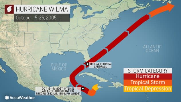
Hurricane Wilma's track in 2005. |
Perhaps the most notable storm to strike Florida in October was Wilma in 2005, the most intense Atlantic hurricane on record. Wilma developed in the Caribbean Sea and eventually rapidly intensified from a Category 1 hurricane to a Category 5 behemoth with winds of 185 mph in just 24 hours.
After making landfall in Florida as a Category 3 storm, Wilma was blamed for more than 20 fatalities and also is listed as the ninth-costliest tropical cyclone in U.S. history.
