Why did water leave Tampa Bay during Hurricane Ian? What to know about reverse storm surge
Tampa Bay's water levels had mostly returned to normal Thursday, but residents who remained behind as Hurricane Ian whipped the western Florida coast saw an unusual phenomenon in the water – it had receded.
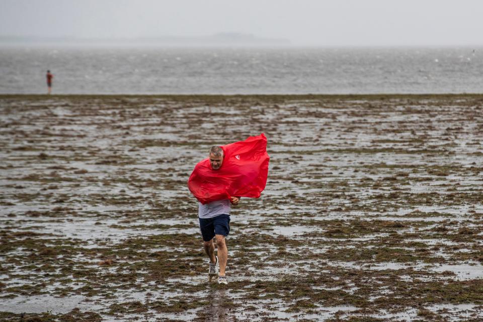
The storm’s powerful winds appeared to draw water away from the Florida coastline Wednesday, exposing sand and silt that's typically covered by about 12 feet of water in Tampa Bay.
Despite warnings from officials to stay back, curious locals posted social media images showing them venturing onto Tampa Bay’s temporary new coastline.
LIVE UPDATES: Tropical Storm Ian still pounding Florida in '500-year flooding event'
Where did the bay waters go? It’s a phenomenon called reverse storm surge, according to AccuWeather senior meteorologist Paul Pastelok, who said it also occurred in the Tampa Bay area during 2017’s Hurricane Irma.
“(Irma) was a very powerful system that went up to the north and sucked the water out of Tampa, and when it passed by, the water came back in and they had some flooding,” Pastelok told USA TODAY.
Here’s what to know about reverse storm surge:

What is reverse storm surge?
Storm surge happens as a tropical storm or hurricane pushes water toward the shore, triggering coastal flooding along bays and inlets.
With reverse storm surge, especially in larger storms like Ian, the opposite happens, explained Pastelok. “It can pull the water out because the wind flow is coming from land to ocean, and it pushes the water,” he said. “The power of the wind is incredible.”
WHAT IS STORM SURGE: Explaining a hurricane's deadliest and most destructive threat
The result is bare ground in some places, particularly along the shoreline, according to Pastelok. “It's the blowout effect of pushing it in.”
The phenomenon can occur during any hurricane, whether it makes landfall along the eastern U.S. coast or in the Gulf, according to the National Weather Service office in the Tampa Bay area.
WERE IAN FORECASTS WRONG?: What experts say about the 'cone of uncertainty'
Why does it happen?
Storm surge can happen near and to the right of where a storm makes landfall, but negative water levels can occur to the left of the landfall location, said National Weather Service Tampa Bay meteorologist Ernie Jillson. Tampa Bay was on the left side of where Ian made landfall as its winds blew from the northeast, he said.

“It depends on the shape of the waterway, and bays are more susceptible because they're like a bowl of water,” Jillson told USA TODAY. “They're protected by land on all sides except one, so that's why they're so susceptible to being emptied out.”
How dramatic the phenomenon appears depends on the storm's intensity, according to Pastelok. Ian made landfall as a Category 4 hurricane Wednesday afternoon with sustained winds of 150 mph over Cayo Costa, Florida – just 7 mph shy of a Category 5 storm, the strongest on the Saffir-Simpson hurricane scale.
RECOVERING FROM DISASTER: As Ian creates havoc, what does home insurance cover?
"When Ian's center got close to the coast, it slowed down, it didn't immediately go right," Pastelok said. "It was kind of scraping the coast, which also contributed to this massive dramatic effect that took place up the coast in Tampa."
How did it impact water levels in Tampa?
Water levels in Tampa Bay had mostly returned to coastlines by Thursday, according to the weather service. “They're running about a half a foot below what they would normally be with the tides, and half a foot is pretty normal,” Jillson said.
It wasn't just Tampa Bay either. During the reverse storm surge, water levels diminished Wednesday in nearby St. Petersburg and East Bay, along with farther north in Cedar Key, to negative figures. “East Bay was minus 7.69 feet, St. Pete was minus 5.50 feet and Cedar Key got down to minus 5.21,” Pastelok said.
There were also reports from the Florida Panhandle of waters being pushed away from the city of St. Marks, located at the head of Apalachee Bay about 25 miles southeast of Tallahassee, according to the weather service office in the state’s capital.
Contributing: The Associated Press
This article originally appeared on USA TODAY: What is reverse storm surge? How Ian drew water from Florida's coast

