Why Utah's long-range summer weather outlook is a bit of a mystery
Meteorological summer is just around the corner, which may surprise some in Utah after the seemingly never-ending winter the state experienced this year.
That long winter led to a record 30-inch statewide snowpack by April 8, a week shy of meteorological spring's halfway point. The snowpack continues to melt at a blistering rate in the mountains as warmer-than-normal temperatures in May are helping pick up the snowmelt pace.
Utah's snowpack has dropped 10.7 inches over the past two weeks, ending Monday at 7.7 inches, or a little more than a quarter of the peak collected this season, according to the Natural Resources Conservation Service.
It appears that warmer-than-normal temperatures will continue into the summer; however, it's not exactly clear if the robust precipitation of the past few months will follow, according to a new long-range outlook issued by the National Weather Service's Climate Prediction Center. The agency says Utah is likely in for another hot summer, but it's still too early to know if it will be wetter or drier than normal over the months of June, July and August.
(Finally) feeling hot, hot, hot
Utah is off to an abnormally cold start to the year mostly because of all the storms it has received so far this year. It ended April with an average temperature of 32.2 degrees Fahrenheit, which was 2.3 degrees below the 20th-century average and the 21st coldest first third of a year since the National Oceanic and Atmospheric Administration began tracking statewide data in 1895.
The pattern of below-normal temperatures really began to end this month as the low-pressure systems that came across the state became weaker and more high-pressure systems have set up, says National Weather Service meteorologist Michael Wessler. It's helped bring in more warm air from the south, resulting in warmer temperatures.
"We are just in a setup, in a pattern, where we're just in this continual warmer-than-average temperatures," he told KSL.com on Monday.
For example, Salt Lake City's average temperature of 65.7 degrees, as of Monday, puts this month on pace to be the city's second-warmest May on record and 4.2 degrees above its 1991-2020 normal, according to weather service data. Wessler said many other parts of the state are experiencing similar bumps above regional normals.
The Climate Prediction Center's long-range outlook indicates it's more probable than not that this trend will continue throughout the meteorological summer months. It lists Utah as having about a 50% to 70% probability of above-normal temperatures over the span of June, July and August, with southeast Utah having the strongest odds for summertime heat.
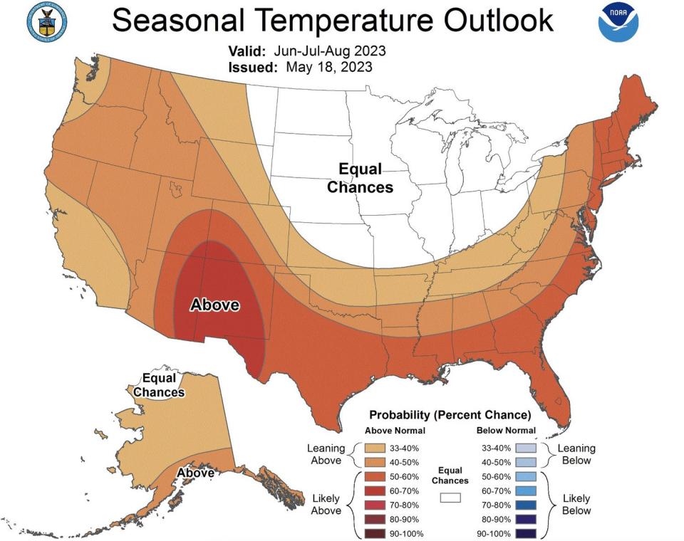
If the outlook comes to fruition, it would continue the trend of the past few summers. Last year was Utah's eighth-hottest meteorological summer since 1895, while 2021's average of 73 degrees is the hottest on record. In fact, 12 of the 13 hottest summers in Utah history have come since 2000, according to National Centers for Environmental Information data.
What about the rain?
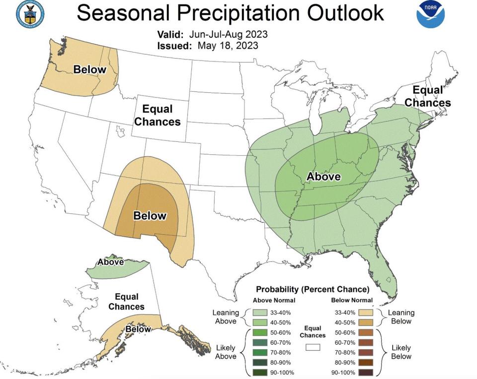
Summer precipitation is less certain at the moment, though the Climate Prediction Center acknowledges that parts of northern Utah have a stronger probability of above-normal precipitation in June.
This, according to Wessler, likely has something to do with a pattern impacting Utah this week. A pair of low-pressure systems, in the Pacific Northwest and Southwest, will help bring scattered showers and thunderstorms over the next few days, as it did Monday. He expects similar storm systems will emerge at times into next month, boosting the odds of stronger precipitation than the June normal.
Yet the center lists southeast Utah as having between a 34% and 40% probability of receiving below-normal precipitation while the rest of the state is listed in "equal chances" over the full three-month span of summer. This essentially means that there's an equal probability of above-normal, below-normal and near-normal precipitation for most parts of the state.
The overall uncertainty likely has to do with the "unsettled pattern" that continues to impact the West, Wessler explains. He says Utahns should still expect showers and thunderstorms to continue into the summer; however, it's difficult to project how much moisture those storms will bring.
"One of the hardest things to forecast in the warm season is convective development, convective weather," he said. "Convected development itself is very hard to forecast (at) a specific given point."
It's worth mentioning that summer is typically the driest season for many parts of Utah, so even a normal season doesn't bring a ton of rain. For example, Salt Lake City could receive a little more than 2 inches of rain over the span of June, July and August and end up with a wetter-than-normal season.
Meanwhile, what makes the center's national map even more interesting, for Utah at least, is that it lists Arizona and New Mexico, as well as the Pacific Northwest, as having the highest probabilities of below-normal moisture. Those areas are usually where Utah's precipitation originates before ending up in the Beehive State.
This could be in relation to the shifting oceanic patterns, Wessler adds. The center issued a notice on May 11 stating that an El Niño pattern is forecast to arrive in the Northern Hemisphere "in the next couple of months" and there's more than a 90% probability that it will last this winter. This typically doesn't impact Utah weather much but it could mess with traditional monsoonal patterns this summer.
"That could delay or just generally reduce the amount of precipitation attributed to the monsoon," he said. "That's where you are seeing the (below-normal outlook)."
Any precipitation, though, would be welcomed after the record winter, so Utah can avoid wildfire issues linked to all the new vegetation growth that can quickly dry out. As it stands, the Great Basin Coordination Center lists Utah as having normal fire risks over the summer.
Some of the fire fuels, especially grass, could dry out if the precipitation stops this summer.
"The more (hot and dry days) that we have, the more rapidly it will dry out the fuels," Wessler said. "That will set us up for a more enhanced wildfire risk. ... The larger fuels — it's less certain what will happen with those."
It's one of the weather-related mysteries that will play out this summer.

