Why are Utah's skies hazy? Blame the abnormally early fire season in Canada
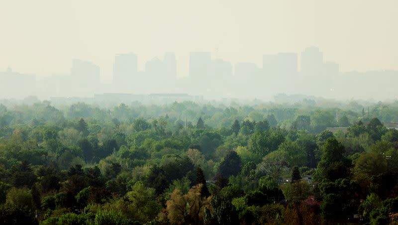
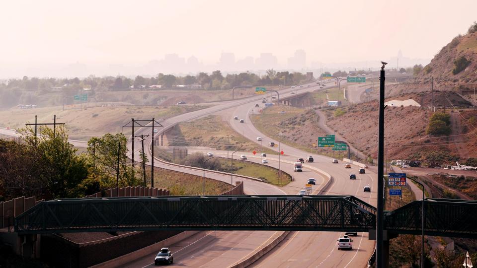
If the skies look a little hazy in northern and eastern Utah this weekend, you can blame the wildfires that are currently ravaging Canada.
The National Weather Service confirmed Friday that smoke primarily from Alberta, Canada, is seeping down into Utah. KSL meteorologist Matt Johnson explains that there are currently a pair of high-pressure systems set up in the West — one over California and another over the Montana-Alberta border — that's pushing wildfire smoke south into the U.S.'s Intermountain region, including Utah.
"We might be seeing it this weekend thanks to that flow out of the north," he said. "It's just coming down in that northerly flow. We are seeing nasty, nasty air. It's just too soon to be seeing the smoke but that's the origin, it's way up north."
Wildfire smoke from the Alberta, Canada fires to our north is filtering in today. 💨😷#utwx pic.twitter.com/0l6iuYIAS9
— Matthew Johnson (@KSL_Matt) May 19, 2023
It's unclear how long this pattern will last. The Utah Division of Air Quality forecast calls for moderate, or yellow air quality across the state Friday, Saturday and Sunday. Agency officials tweeted Friday afternoon that smoke will "continue to move southeast and hopefully move out by Sunday with forecasted wind."
"If you have chronic heart or lung conditions pay attention to your body. Avoid outdoor exertion if you're in an area with visible smoke or haze," they added.
So what's the deal with the wildfires? It mostly goes back to the different climate patterns in the West this winter.
While Utah and a good portion of the West and Midwest benefited from robust — and record-setting — moisture this winter, the Pacific Northwest and western Canada missed out on the storms, as the jet stream set up over California before pelting Nevada, Utah and several states east of the Beehive State.
Spring storms helped the situation some but the Pacific Northwest region in the U.S. had its 32nd-driest first half of the water year, from October 2022 through March 2023, according to the National Centers for Environmental Information. Its records date back to 1895. The agency reported that Utah had its fourth-wettest first half of the water year, to give an idea of the stark contrast in winters.
Canada experienced a similar warm, dry pattern as the Pacific Northwest. Country officials note that the average Canadian temperature this winter was 1.9 degrees Celcius above its baseline average, or about 3.4 degrees Fahrenheit. Many parts of western Canada recorded temperatures between 4.5 to 9 degrees Fahrenheit above the average between the start of December and the end of February.
It was also dry, especially in the country's western half. One expert told CBC this week that the winter "provided one of the lowest snowpacks he's seen."
Both of these helped spark an early and abnormally large start to Canada's wildfire season, which has worsened in recent weeks. Terri Lang, a warning preparedness meteorologist for Environment and Climate Change Canada, told NBC News on Thursday that an "omega block" settled over the country, causing more extreme heat. She said it's a pattern that typically sets up over the summer but it's a "very unusual pattern" for May.
Natural Resources Canada reports that, through Wednesday, there have already been 1,402 fires that have scorched about 1.28 million acres of land in the country, an uptick of 132% in total fires and a 1,605% in acreage burned over the 10-year average by mid-May.
The agency adds that there are dozens of active uncontrolled wildfires in the country and that Alberta has declared a state of emergency over the issue. The province reported Thursday evening that more than 10,000 residents remain evacuated because of the fires.
Thousands of firefighters from all over the country and even from the U.S. have been dispatched to help out.
"Canada is at national preparedness level 5, indicating full commitment of national resources is ongoing, demand for resources is extreme and international resources are being mobilized," Natural Resources Canada officials wrote Wednesday. "Nationally, the number of fires is well above average for this time of year and nearly 16 times the average for area burned for this time of year."
There may not be long-term relief in sight, either. CBC also reported long-range forecasts indicate there's a strong probability that above-normal temperatures will continue into the summer, which may exacerbate the country's drought and wildfire situation, especially in its western half.
That could lead to more incidents where smoke from those fires ends up in Utah later this year.
Full seven-day forecasts for areas across Utah — and current air quality conditions — can be found online, at the KSL Weather Center.

