Wicked snow, winds threaten delays and closures across Quebec
A high-impact winter storm affecting a large swath of Canada won’t spare Quebec heading into the holiday weekend, where residents are urged to postpone non-essential travel over the next couple of days.
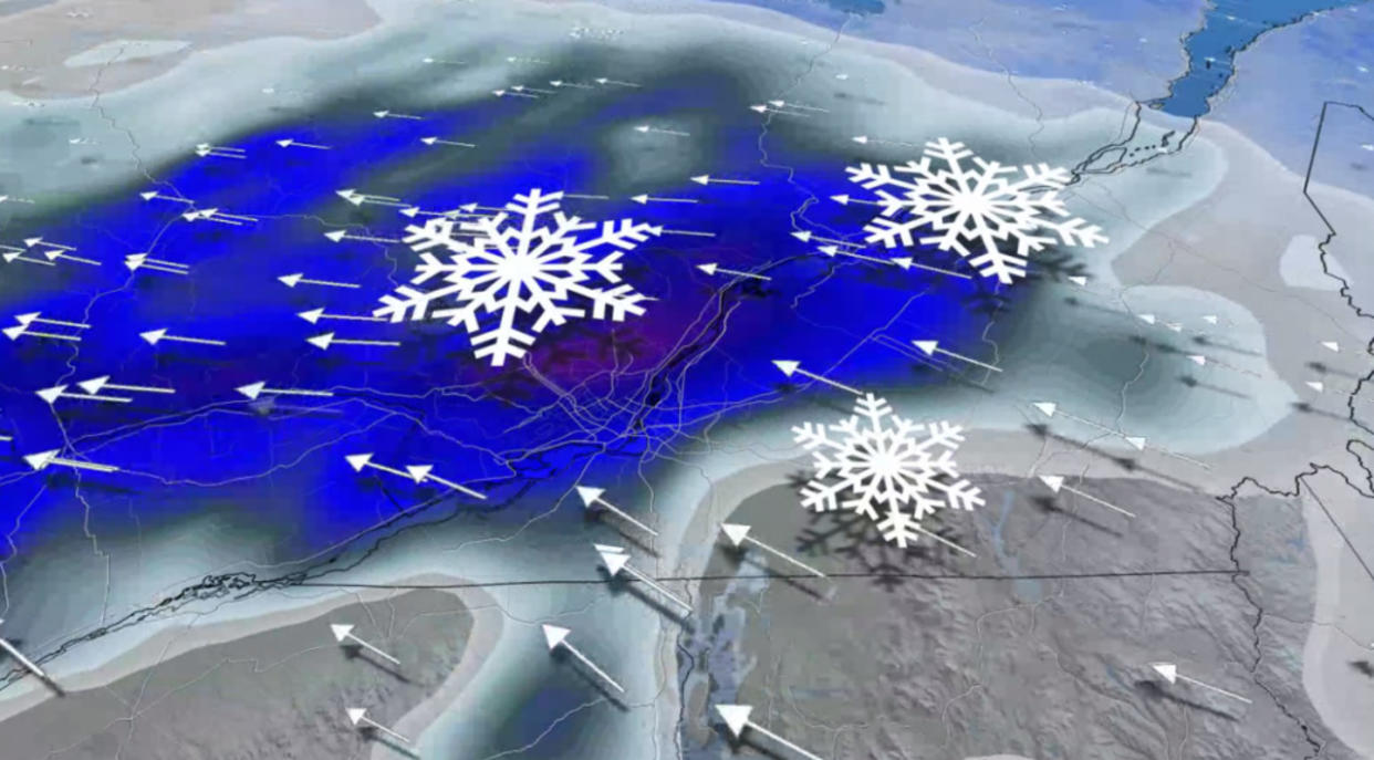
Heavy snowfall, high winds, a flash freeze, and whiteout conditions are all possible as the storm affects the province. Plan your holiday travel accordingly.
RELATED: Holiday havoc: Vast, 3,000-km-sized storm puts travel plans in peril
Precipitation starts Thursday overnight into Friday
Winter storm warnings and snowfall warnings blanket Quebec as the storm steadily makes its way toward the province.
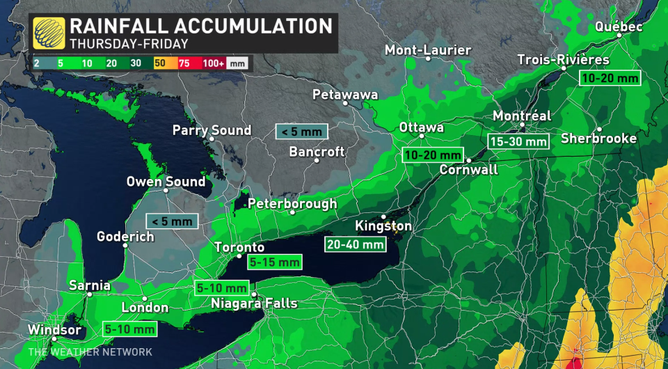
Precipitation will begin pushing into southern Quebec late Thursday night into Friday morning. A complex mix of temperatures will force the precipitation to change between rain and snow several times as the event unfolds over the next 24-48 hours.
Snow will arrive for southern Quebec very early Friday morning, with the heaviest accumulations likely around the National Capital Region. Morning commuters may deal with 10-15 cm of snow on Friday morning before warmer air arrives and precipitation changes over to rain.
Rain will continue through the day Friday before the cold front arrives later in the day.
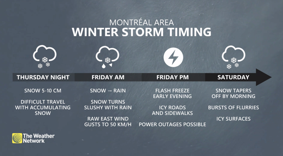
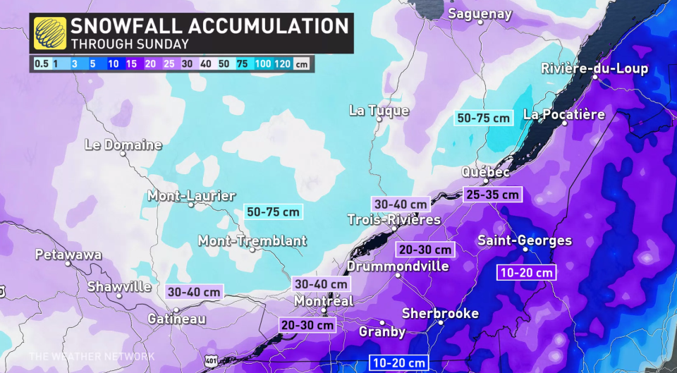
Temperatures will quickly tumble behind the cold front. The arrival of cold air will force rain to change back over to snow. Significant snowfall rates are forecast through Friday for the Laurentians, and communities along the St. Lawrence including Montreal.
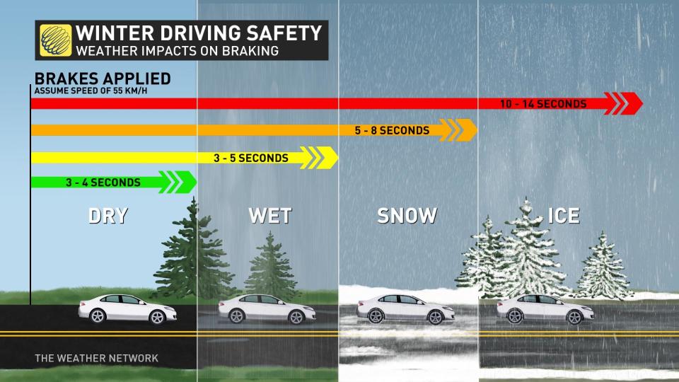
Any wet surfaces run the risk of quickly freezing as the frigid air rushes across the province. Flash freezes are exceptionally dangerous to any motorists caught on the roads during or after the temperature drop.
Gusty winds will pick up behind the cold front, with gusts of 70-90 km/h common across the southern half of the province. These gusts could lead to damage or power outages throughout the region. Blowing snow and low to near-zero visibility will also pose a significant risk to motorists.
Residents are reminded to pack emergency kits in their vehicle if travel absolutely cannot be avoided.
High winds and blowing snow continue Saturday for Christmas Eve
Snowfall rates will calm down as we head into Christmas Eve, but slick roads and high winds will make travel difficult across Quebec throughout the day. Whiteouts will remain a hazard Saturday as blowing snow continues.
Although snowfall rates will lighten, weather threats will make travel difficult Saturday as winds will remain blustery through Christmas Eve and widespread snow will continue. With blowing snow in place, whiteouts will still be possible.
Daytime high temperatures will only reach the negative single digits across Quebec, with much colder wind chill values expected for the duration.
Cold temperatures persist, but light snow for Christmas on Sunday
Blowing and drifting snow with snow flurries will continue across the province Christmas Day, however snowfall will be rather light.
Temperatures will remain quite cold and hold at minus double-digit highs across the northern half of the province Sunday through early next week.
ICYMI: Our Chief Meteorologist @ChrisScottWx along with meteorologists @ThatMetGirl @matt_grinter and weather expert @KMacTWN answer your questions about the incoming #ONStorm #QCStorm 🎙❄ https://t.co/nzsF0L6jeo
ICYMI: Our Chief Meteorologist The Weather Network on Twitter: "ICYMI: Our Chief Meteorologist @ChrisScottWx along with meteorologists @ThatMetGirl @matt_grinter and weather expert @KMacTWN answer your questions about the incoming #ONStorm #QCStorm 🎙❄ https://t.co/nzsF0L6jeo / Twitter" along with meteorologists The Weather Network on Twitter: "ICYMI: Our Chief Meteorologist @ChrisScottWx along with meteorologists @ThatMetGirl @matt_grinter and weather expert @KMacTWN answer your questions about the incoming #ONStorm #QCStorm 🎙❄ https://t.co/nzsF0L6jeo / Twitter" The Weather Network on Twitter: "ICYMI: Our Chief Meteorologist @ChrisScottWx along with meteorologists @ThatMetGirl @matt_grinter and weather expert @KMacTWN answer your questions about the incoming #ONStorm #QCStorm 🎙❄ https://t.co/nzsF0L6jeo / Twitter" and weather expert The Weather Network on Twitter: "ICYMI: Our Chief Meteorologist @ChrisScottWx along with meteorologists @ThatMetGirl @matt_grinter and weather expert @KMacTWN answer your questions about the incoming #ONStorm #QCStorm 🎙❄ https://t.co/nzsF0L6jeo / Twitter" answer your questions about the incoming The Weather Network on Twitter: "ICYMI: Our Chief Meteorologist @ChrisScottWx along with meteorologists @ThatMetGirl @matt_grinter and weather expert @KMacTWN answer your questions about the incoming #ONStorm #QCStorm 🎙❄ https://t.co/nzsF0L6jeo / Twitter" The Weather Network on Twitter: "ICYMI: Our Chief Meteorologist @ChrisScottWx along with meteorologists @ThatMetGirl @matt_grinter and weather expert @KMacTWN answer your questions about the incoming #ONStorm #QCStorm 🎙❄ https://t.co/nzsF0L6jeo / Twitter" 🎙❄ The Weather Network on Twitter: "ICYMI: Our Chief Meteorologist @ChrisScottWx along with meteorologists @ThatMetGirl @matt_grinter and weather expert @KMacTWN answer your questions about the incoming #ONStorm #QCStorm 🎙❄ https://t.co/nzsF0L6jeo / Twitter"
— The Weather Network (@weathernetwork) The Weather Network on Twitter: "ICYMI: Our Chief Meteorologist @ChrisScottWx along with meteorologists @ThatMetGirl @matt_grinter and weather expert @KMacTWN answer your questions about the incoming #ONStorm #QCStorm 🎙❄ https://t.co/nzsF0L6jeo / Twitter"
WATCH: To have a 'White Christmas' specific criteria needs to be met
Check back for the latest on the forecast across Quebec.

