Widespread snow threat hits Ontario this weekend, 10-20+ cm on the line
Winter has arrived in full force across Ontario, with all eyes on a major low pressure system set to rapidly intensify as it heads into the Great Lakes region on Friday. Dangerous blizzard-like conditions are forecast from Friday night into Saturday.
With more cold air to work with, and less moisture and rain than Tuesday's slushy Texas low, snowfall totals could be significant in some areas this time around. There's also the risk for extensive blowing and drifting snow, and localized wind damage and power outages.
There is high confidence that this system will bring significant winter weather to the region.

Going somewhere? Check out the current highway conditions before heading out!
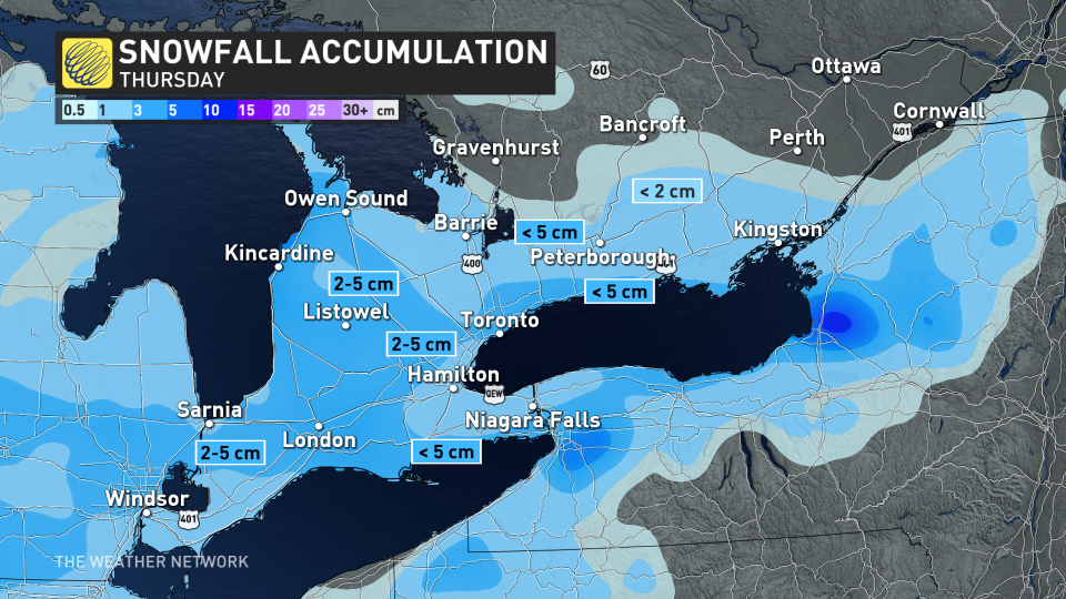
Thursday: Weak clipper drops 5 cm of snow
Ahead of this bigger weekend storm, a weak clipper system from the U.S. Midwest will track through southern Ontario on Thursday, bringing with it a couple of centimetres of snow. Snow moved into the southwest during the early morning hours, spreading across the Greater Toronto Area (GTA) by 8 a.m., before gradually ending ahead of afternoon commute.
Up to 5 cm of snow is possible for most areas, which could be enough to slow travel times. Snow will remain south of Bracebridge and Bancroft, and will depart Kingston into the evening hours.
PHOTOS: First dose of winter hits, with more snow coming to Ontario this week
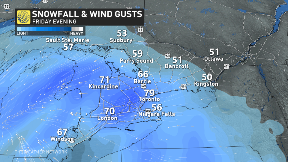
Friday evening into Saturday: Heavy snow and blizzard-like conditions possible
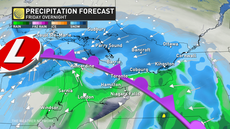
Late Friday and into Saturday, another strong, colder system is forecast to bring widespread, heavy snow and blizzard-like conditions to the province. Low pressure will rapidly intensify as it heads northeast into the Great Lakes.
This storm will have two important differences than the last one that hit on Tuesday: slightly colder air and stronger winds.
The colder air will lend to more widespread snow to start, helping to keep it around longer rather than the transition to rain, washing it away. We are still however, expecting some areas to transition into a rain/snow mix, particularly along the Lake Erie and Lake Ontario shores.
The stronger winds will also increase the risk for whiteouts and blizzard-like road conditions in southern Ontario.
Timing:
By late Friday afternoon, the system will move into southwestern Ontario and quickly intensify by the evening. This is where a high impact scenario may take place as millions of commuters attempt to get home. Expect heavy snow coinciding with gusts between 60-80 km/h. Travel is not recommended.
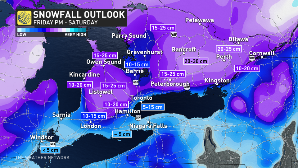
The system will engulf the rest of the province by midnight. Snowfall rates could reach 3-5 cm per hour, making for some treacherous travel through the night. The heaviest snow will fall late evening and through the overnight hours, and linger into Saturday morning for eastern Ontario, including Ottawa.
A widespread swath of 10-20 cm of snow is possible, with some localized areas such as Bancroft, and north of Peterborough, possibly exceeding the 20 cm mark. Around 20 cm is likely for the Ottawa area.
For areas that do transition to rain, such as the Lake Erie shorelines, less than 10 cm is likely. The line between significant snow and rain/snow mix will once again be razor thin for the GTA and Golden Horseshoe.
Sustained winds of 40-50+ km/h are likely, and gusts of 60-80+ km/h. In addition to reduced visibilities on the roads, the winds could spell trouble for power lines, as well.
Multi-day lake-effect snow squalls with coldest air of the season
Colder than seasonal temperatures will dominate starting Sunday, and continue into next week, as well. This will set up an extended lake-effect snow squall event of more than five days, as arctic air floods into the region.
Northwesterly winds late Saturday will develop lake-effect bands for the Saugeen Shores, Wasaga Beach, Barrie and surrounding areas. Into Sunday and Monday, westerly winds will cause lake-effect snow to pile up for the Bruce Peninsula, and areas east of Georgian Bay like Parry Sound, Huntsville, Bracebridge, and Gravenhurst.
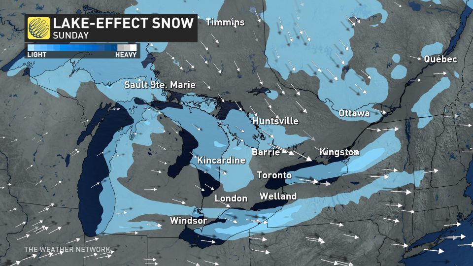
The wind direction will be changeable through the prolonged event, so the snow squalls will meander across the snow belts resulting in hazardous travel at times. The meandering bands should also prevent the truly impressive totals that we sometimes see for specific locations when the wind does lock into place. A milder pattern is expected for the final week of January, but winter will return for February once again.
WATCH: Weather 'hat-trick' hits Ontario and Quebec, creating treacherous travel conditions
Be sure to check back for the latest weather updates across Ontario.
