Wild forecast calls for anywhere between 1 and 8 inches of snow in south-central Pa.
A storm could deliver anywhere from one inch to half a foot of snow in parts of south-central Pennsylvania, and the heaviest precipitation is expected to fall during the Tuesday morning commute, according to the National Weather Service.
The weather service has revised its forecast because the storm has shifted farther south than previously expected, according to a winter storm watch issued mid-morning on Monday.
A winter storm watch is now in effect for Adams and York counties for tonight through Tuesday afternoon, the weather service says.
Meanwhile, a winter storm warning has been issued for Lebanon County, where 4 to 8 inches of snow could fall. The higher amounts are expected to be on ridges north and west of Interstate 81, the weather service states. Winds could gust to 35 m.p.h.
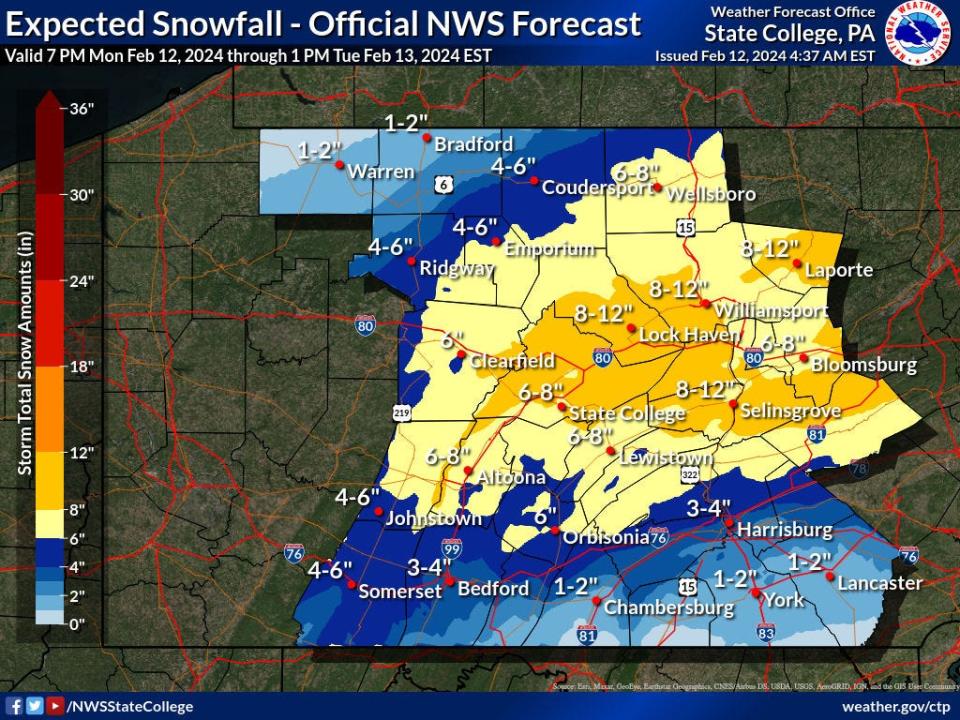
In York and Adams counties, the weather service is calling for one to five inches of snow with the highest amounts north of the Pennsylvania Turnpike and west of Interstate 83.
The lowest accumulation is expected to be in far southeastern York County, the winter storm watch states.
A storm will bring rain in from the south this evening. It will turn to snow through the night, and likely produce intense snowfall rates of 1"/hr or greater right during the morning commute. See the progression of precipitation in this animation. pic.twitter.com/xGvh3YxpNp
— NWS State College (@NWSStateCollege) February 12, 2024
When will the snow arrive in south-central Pa.?
Rain is predicted to move in Monday night, and the changeover to snow is expected in the 4 a.m. to 6 a.m. time frame, National Weather Service senior forecaster Mike Dangelo said.
While the rain will move in from south to north, the changeover to snow will happen in the reverse direction, Dangelo said.
One to two inches of snow could fall per hour, the winter storm watch states.
The snowfall is expected to be heaviest during the Tuesday morning commute, and drivers are advised to stay off the roads if they don't need to go out, Dangelo said.
The snow is expected to be wet and heavy, and residents should take it easy when shoveling to prevent a heart attack, he said.
In the past 24 hrs, there has been an immense southward shift in the track of the storm system. As a result, south-central PA is now "under the gun" for a plowable snowfall late tonight through midday tomorrow. The AM commute looks like a total nightmare. Snow map to come soon.. pic.twitter.com/r3tPvaW0vN
— MU Weather Center (@MUweather) February 12, 2024
When will the storm end in south-central Pa.?
The storm is expected to end by noon on Tuesday, Dangelo said.
The sun might come out, and temperatures are predicted to rise into the upper 30s to low 40s.
That will help to melt some of the snow that has fallen.
This article originally appeared on York Daily Record: How much snow will south-central Pa. get? It ranges from 1 to 6 inches.

