Perins Peak Fire northwest of Durango has charred 100 acres; pre-evacuation plans posted
DURANGO — The 100-acre Perins Peak Fire near Durango, Colorado, may have been caused by human activity, according to a U.S. Department of the Interior Bureau of Land Management news release.
The blaze broke out on the afternoon of May 24 and quickly grew to what was estimated at just over 100 acres. Fire managers re-estimated the size of the fire's footprint Wednesday to 100 acres, while the Inciweb multi-agency informat website lists it at 102 acres.
On the morning of May 25 there were 95 firefighting personnel assigned to the fire, which is "burning in dense Gamel oak as well as mixed conifer in the drainage bottoms, according to the Inciweb website.
UPDATE: Perins Peak Fire west of Durango reaches 36% containment Thursday evening
No containment percentage was announced for the wildfire in an update posted around 10 a.m. May 25 on the airnow.com website, which tracks wildfires via an interactive map.
“The cause of the fire is under investigation and is suspected to be a human-caused ignition," the Bureau of Land Management news release stated.
“Fire suppression efforts will be visible again today,” Durango Fire & Rescue said in a Facebook post Wednesday morning. “Durango Fire is supporting BLM - Southwest Colorado Fire and Aviation Management Unit and Colorado Parks and Wildlife - Durango. A type 3 Incident Management Team is assuming the incident this morning.”
Fire managers are assessing how best to attack the fire.
"We have a really good weather window today and tomorrow to use some aggressive, direct tactics, so, folks on the ground putting direct line in right at the fire's edge, in coordination with the aircraft support we will be using — and you will likely see — in the air this afternoon and throughout the day," Perins Peak Fire Incident Commander Jay Godson said in a morning briefing posted online.
"Hotshot crews will assess opportunities to construct control lines and/or engage in direct suppression at the fire's edge if safe to do so," fire managers reported on the morning of May 25 via the Inciweb website.
Temperatures are expected to be slightly warmer and humidity low. Winds are forecast between 7 and 12 mph from the northwest with gusts up to 23 mph in the afternoon, the Inciweb report stated.
The agency praised Durango Fire Protection District incident commander Scott Nielsen for his leadership on May 24 after the fire broke out.
The unit leading the fight against the wildland blaze is the San Juan Type III Incident Management Team.
“Responding agencies include Durango Fire Protection District, U.S. Forest Service and Bureau of Land Management,” the La Plata County Government Facebook page said. “A Type 3 helicopter is actively engaged as well as four air tankers. A Type 1 helicopter is en route as well. “

Air assets led early efforts
“The initial attack included a substantial aviation component with multiple air tankers and helicopters,” the DOI news release stated. “Due to the safety concerns regarding rugged terrain and no road access ground resources did not engage the fire. Several hot shot crews and other resources will be hiking into the fire early Wednesday morning.”
Incident Commander Godson said the effort dropped 30,000 to 40,000 gallons of fire retardant on the blaze the first day.
By the evening officials reported things had calmed down a bit.
“The fire was last mapped at 105 acres and fire behavior has calmed significantly,” according to an update Tuesday evening on the La Plata County Government Facebook page. “The fire burned from the bottom of the Rock Ridge Trail to the top of Perins Peak, and has reached the Lightner Creek Fire scar from 2017.”
“Residents can expect to see smoke and flames throughout the night,” the update noted. “Firefighters will remain in the area.”
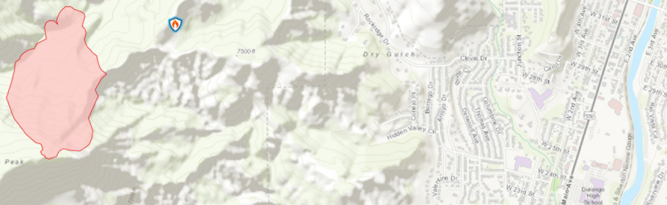
Durango Interagency Fire Dispatch posted an early image of the fire around 6:30 p.m. according to the post’s Facebook time stamp, when the fire size was noted as being 20 acres. Later that agency said the fire was “burning west of Durango on Bureau of Land Management and Colorado Parks and Wildlife land.”
Durango Fire & Rescue's final update of the night noted that smoke would be in the air.
"Air resources beginning to shut down for the night. Will continue in the morning," the post at about 9:30 p.m. stated. "Durango should expect smoke to settle down into the city tonight. The fire is currently NOT running towards the city. Crews are prepping for fire operations tomorrow."

Public meeting, online assets
La Plata County's government and local, state and federal emergency service responders have a lot of experience with online updates, honed in part during the 416 Fire, which burned from June 1 to July 31 2018. Agencies were hard at work providing the community with updates and access to online pre-evacuation area information.
Public officials are using online assets to reach the public, and that includes a public meeting that officials encourage people to attend online or by phone due to limited seating.
Authorities posting online updates advise people to go to https://tinyurl.com/bdcv9s6a to find a map and information on pre-evacuations.
“According to La Plata County Government, a pre-evacuation notice has been ordered for County Road 208 and the Dry Fork and Rock Ridge subdivisions as well as County Road 206 to Highway 160,” the Durango Interagency Fire Dispatch page posted around 8:30 p.m. “Trail access has been closed to Overend Mountain Park, Twin Buttes, and Perins State Wildlife Area.”
A public meeting was planned May 25 at 6 pm inside the La Plata County Administration Building Board Room, 1101 East 2nd Ave., in Durango.
“Seating is limited, so a virtual option will be available, the DOI news release said.
The meeting can be viewed remotely at https://us02web.zoom.us/j/86550880765?pwd=T0lvaC9rK0R6eXB2QUZ2ODdUZnF1UT09, and the passcode is 466417
There’s also a dial-in option at 669-900-9128, with a Webinar ID of 865 5088 0765.
More: Fire restrictions to go into effect soon on Navajo Nation
More: With last frost over, San Juan County can expect rapid warming trend this week
Contact John R. Moses at 505-564-4624, or via email at jmoses@daily-times.com.
Support local journalism with a digital subscription: http://bit.ly/2I6TU0e
This article originally appeared on Farmington Daily Times: Perins Peak Fire forces pre-evacuation plans in Durango, Colorado

