Storm to return mudslide, flood danger in Southern California Friday, Saturday
A storm is forecast to dip far enough south to bring soaking rain to much of the California coast, including Southern California, from Friday afternoon to Saturday morning.
A blockbuster storm with high winds, pounding surf and widespread torrential rainfall and severe flash flooding is not anticipated. However, seas and surf will remain stirred up from storms earlier in the week.
However, the cumulative nature of the rainfall in central and northern areas from recent prior storms, as well as a thorough soaking in Southern California with this storm can lead to travel delays, disruptions to outdoor activities and other problems.
There will be the risk of isolated flash flooding and mudslides.
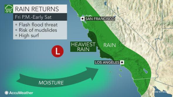
The greatest risk will be in recent burn scar areas as the charred landscape in these locations cannot absorb much rainfall. Motorists should be on the lookout for debris on the roads.
Even where there is not a significant amount of urban flooding, the rain can make for slick conditions, especially at intersections and along winding roads.
"Snow levels are forecast to be well above pass levels in Southern California," according to AccuWeather Senior Meteorologist Kristina Pydynowski.
Motorists heading over the Grapevine may encounter some fog from Friday night to Saturday morning.
Since only limited moisture is forecast to reach the Sierra Nevada farther north, significant wintry conditions are not anticipated for Donner Summit and the Mount Shasta area.
The bulk of the rain from this storm will push well inland and diminish by Saturday afternoon along the coast. However, there may be spotty showers left behind. Some showers will reach the California and Arizona deserts.
Conditions are expected to be free of rain around Los Angeles as the Rams take on the Cowboys in the NFL playoff game during Saturday evening.
Download the free AccuWeather app to see the latest forecast for your location.
Rainfall has been close to average over much of Southern California and near to slightly below average over Northern California since early November. This has substantially reduced or ended the wildfire threat for the time being.
2018 brought the worst wildfire season since at least 2004 with more than 1.6 million acres burned in California, according to Cal Fire. As numbers continued to be crunched, the 2018 fire season may end up being the worst on record.
The periodic rainfall this winter should continue to keep the landscape reasonably moist and the wildfire risk low.
The winter months typically bring California the bulk of its rainfall.
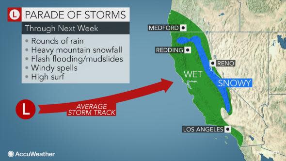
While most of the storms are likely to roll ashore much farther north over the northwestern United States this winter, more storms are expected to dip far enough snow to bring Southern California some needed moisture.
A second storm may spin southeastward from the Pacific Ocean later Sunday and Sunday night with another dose of mainly light rain for Southern California.

