Wildfire updates: Newsom declares state of emergency as Dixie, Tamarack, Fly fires spread


- Oops!Something went wrong.Please try again later.
As California’s wildfire season rages on and firefighters continue to battle multiple blazes, Gov. Gavin Newsom declared a state of emergency in Alpine, Butte, Lassen and Plumas counties.
The proclamation is in response to the Dixie, Tamarack and Fly fires, which collectively have burned more than 249,000 acres across the state. The state of emergency gives the affected counties greater access to state resources.
In a Friday news release, the governor’s office said it issued the emergency order because the fires “collectively have destroyed homes, caused the evacuation of residents and damaged critical infrastructure.”
Firefighters have struggled to gain control over any of the major blazes. The Dixie Fire grew 80,000 acres over 48 hours from Thursday to Saturday.
The Dixie Fire is burning on the border of Butte and Plumas counties, in the burn scar of the deadly 2018 Camp Fire. It has rapidly expanded to 181,289 acres (228 square miles), growing 40,000 acres since Friday morning.
Containment is at 19%, according to Cal Fire’s Butte unit, a slight uptick from 18% Friday.
#DixieFire 07.24.2021 Morning Update
To prepare yourself for wildfire, go to https://t.co/QzoluRjxVi@tehama_s @CALFIRELMU @ButteSheriff @plumascounty @LassenNF pic.twitter.com/TZgZZIW4nF— CAL FIRE Butte Unit/Butte County Fire Department (@CALFIRE_ButteCo) July 24, 2021
Mandatory evacuations have been ordered in numerous areas of Plumas County, and within the communities of Jonesville and High Lakes in Butte County.
A fire burning east of the Dixie, dubbed the Fly Fire, prompted additional evacuation orders in Plumas County along Highway 70 at Chandler Road, and put evacuation warnings in place for West Quincy and surrounding areas. More detailed information on Plumas evacuations is available via the county website.
Crews are responding to the Fly Fire as part of the eastern zone of the Dixie Fire.
Chris Waters, the Cal Fire fire behavior analyst at the Dixie Fire, said in a Friday evening update that the fire was behaving less erratically through the day than earlier in the week. Waters had previously called the fire’s wild behavior “unprecedented at a historical level.”
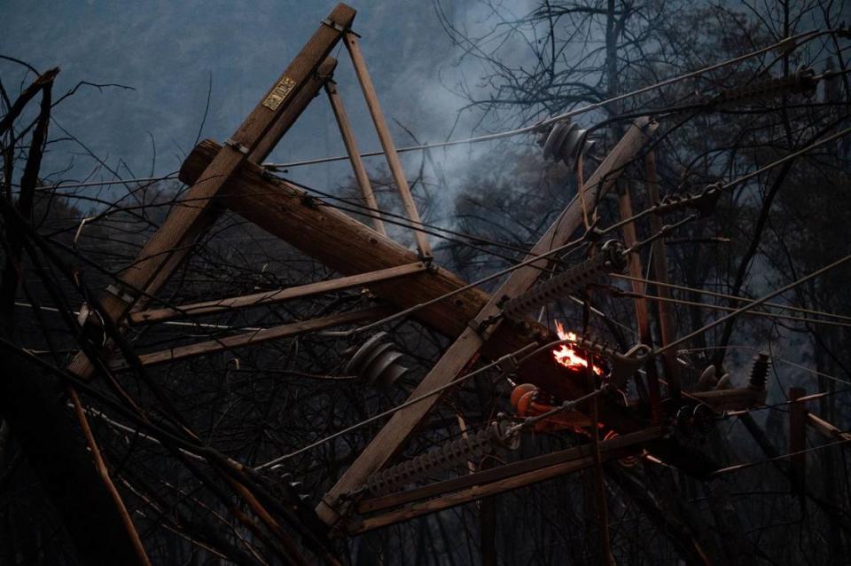
Still, the fire destroyed eight more structures Friday, bringing the total to 16. Another 10 were damaged. Cal Fire officials said that 7,010 structures are threatened as the fire continues to spread, including numerous Native American archaeological sites.
Officials expect dry weather to continue, with temperatures spiking into the triple digits through the weekend. Incident meteorologist Julia Ruthford said the weather outlook could create “critical” conditions during the weekend that might increase fire spread.
Pacific Gas and Electric Co. has suggested its equipment likely sparked the Dixie wildfire; a troubleman observed the fire, as well as two blown fuses on a power pole, while inspecting an outage near its origin zone, PG&E wrote.
PG&E announced Wednesday that it would move 10,000 miles of power lines underground in the coming years to decrease fire risk.
Although most of the smoke from the fire has pushed east into Nevada, small amounts drifted south into the Sacramento area Friday afternoon, affecting capital residents for the first time since the fire began July 14. Officials expect the majority of the smoke to continue pushing east into Nevada on Saturday.
More than 4,200 personnel are now assigned to the Dixie Fire.
Dixie Fire map
Source: National Interagency Fire Center
Tamarack Fire
The Tamarack Fire has charred 65,150 acres (101 square miles), according to Humboldt-Toiyabe National Forest officials. Crews have gained 4% containment and the fire spread an additional 7,000 acres overnight.
The fire ignited in Alpine County and crossed the border into Douglas County, Nev., earlier this week. The fire jumped Highway 395 in Nevada on Wednesday afternoon, closing the road. Caltrans also closed Highway 395 between the Highway 89 junction and the Nevada state line.
The wildfire has prompted mandatory evacuations in Alpine County for Markleeville, Mesa Vista and other surrounding communities and campgrounds. Douglas County officials also issued evacuation orders for the Topaz Ranch Estates and Topaz Lake areas.
The fire has destroyed at least 15 structures in Alpine County. Estimates are not yet available for Douglas County.
More than 1,300 firefighters are assigned to the incident, which was sparked by lightning more than two weeks ago but laid mostly dormant until gusty winds roared it to life.
Caltrans closed stretches of Highway 88 and Highway 89 in Alpine County this week. Highway 88 remains closed from Picketts Junction in Markleeville to the Nevada state line. Highway 89 is closed at the intersection with Highway 4.
Tamarack Fire map
Source: National Interagency Fire Center
Other wildfires
▪ The Fly Fire is burning in the Plumas National Forest, directly east of the Dixie Fire and north of the town of Quincy. It is being handled as part of the Dixie Fire.
The fire has charred 2,800 acres with 5% containment, Cal Fire officials said in their Saturday morning Dixie Fire update.
The fire ignited at Highway 70 and Butterfly Valley-Twain Road and has prompted mandatory evacuation orders in the surrounding area, including the west part of Quincy.
▪ The Beckwourth Complex, a pair of fires burning in Plumas National Forest, stands at 105,670 acres and is not expected to expand beyond its current perimeter, Forest Service officials said in a Thursday evening update. The complex previously held the position of California’s largest wildfire this season.
The fire complex is now 98% contained and officials lifted all evacuation orders and warnings.
The larger of the two fires within the incident, the Sugar Fire, flared and destroyed several homes in the town of Doyle last week.
Like the Tamarack Fire, lightning started the Beckwourth Complex in early July.
