Wildfires continue to make California’s air quality unhealthy, including Sacramento
The skies are darkened by haze, and you may have woken up to ash on your car for a second straight day.
How unhealthy might Thursday’s air conditions be in Northern California?
Smoke from ongoing wildfires, especially the two major lightning complexes raging in the North Bay and the Santa Cruz area, continues to seriously impact air quality across the state, including the capital region.
Conditions in many parts of the state are bad enough to pose a hazard to those spending any significant stretch of time outdoors, or anyone who may be allowing outside air into their home.
The air quality index Thursday morning ranged from “unhealthy” to “very unhealthy” levels across wide swaths of the greater Sacramento area, according to the nationwide monitor at AirNow.gov and local readings from SpareTheAir.com. There’s significant particulate matter (PM 2.5) pollution across a vast majority of California, those monitors show.
A general rule of thumb: If you can smell wildfire smoke or it stings your eyes or throat, any significant time spent in those conditions can be hazardous to your health. If you’re outside, head indoors; if you’re inside your home and you can still smell it, you should take measures from air conditioning improvements to sealing up window cracks, to smoke-proof your home.
In terms of actual measurable pollution levels, Thursday’s worst readings are predictably in the immediate vicinity of the two 120,000-plus-acre fires currently burning in the North Bay and South Bay areas.
The SCU Lightning Complex burning in the Santa Cruz mountains has surged AQI levels past 300, into “hazardous” territory for roughly the northern half of Santa Cruz County, according to AirNow.
And the LNU Lightning Complex, which since early Wednesday has rolled into the areas just east into Solano County from Napa, pumped the AQI up to around 285 in the Vacaville area shortly before 8:30 a.m., according to a Spare the Air alert.
Air quality maps also show AQI levels from 101 to 150 (orange shading, denoting “unhealthy for sensitive groups”) and 151 to 200 (red, meaning unhealthy for the general population) blanketing essentially the entire Sacramento region.
TODAY’S AIR QUALITY
This live-updating map shows the combined readings for particulate matter and ozone.
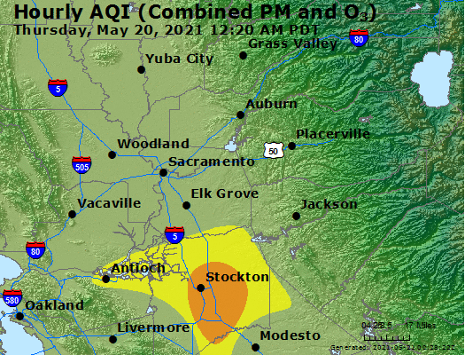
Source: airnow.gov
The south and east parts of Sacramento County, including all of Elk Grove, Galt, Sloughhouse, Rancho Murieta and parts of Folsom, are in red; the rest of the county is in orange.
In Yolo County, the Davis area was in orange territory as of 10 a.m. Thursday, and most of the county from Esparto to its west border with Napa is in red, unhealthy territory. The southwest corner of Yolo, in and around Winters, has “very unhealthy” AQI readings between 201 and 300 that are marked light purple on the maps.
A solid chunk of the foothills and all of the Lake Tahoe area are in the red, too: the entirety of Amador, Calaveras and Alpine counties, plus most of El Dorado County and the east half of Placer County had unhealthy air conditions Thursday morning, according to AirNow.
