Wind chill in Sioux Falls, surrounding areas will dip way into negative temperatures, NWS says
It's going to be a cold, cold world out there Tuesday. The National Weather Service is advising people to bundle up and get ready in advance of temperatures dropping overnight, which will cause wind chills to reach minus 25 to minus 35 in the Sioux Falls area.
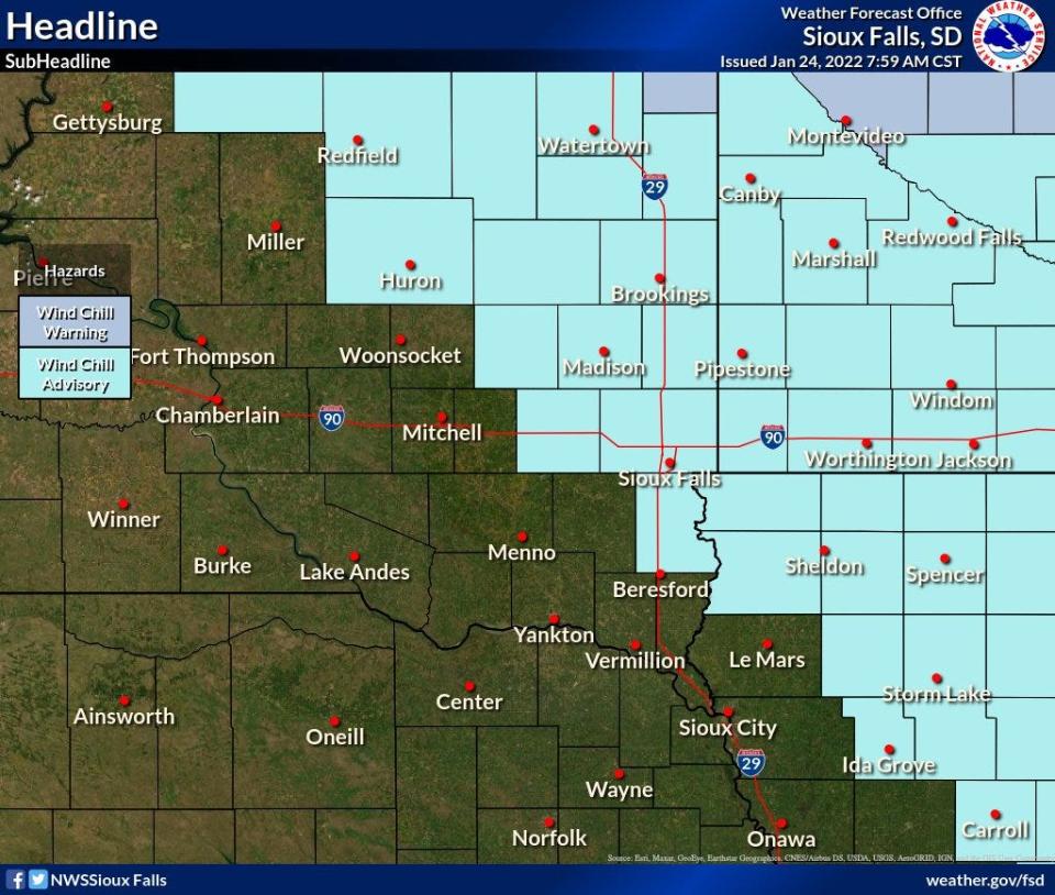
The NWS has put Sioux Falls and surrounding areas under a Wind Chill Advisory beginning at 9 p.m. Monday through noon on Tuesday.
Brief periods with wind chills colder than 35 below zero are possible in portions of southwestern Minnesota, according to the NWS.
What's the forecast?
It's going to be cold Monday night and Tuesday morning. Wind chills will be double digits into the negatives all around Sioux Falls with winds between 5 and 15 mph, according to the NWS.
During the Wind Chill Advisory period the cold wind chills could cause frostbite on exposed skin in as little as 30 minutes, according to the NWS.
When will it get cold?
Monday night into Tuesday should be the coldest time.
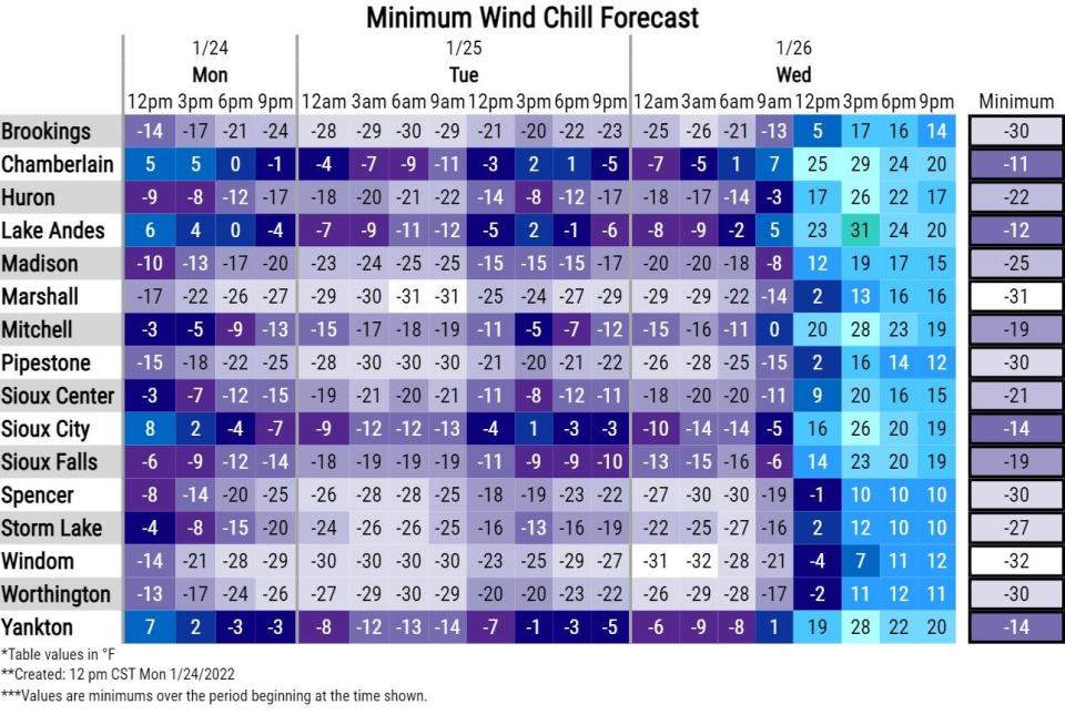
Sioux Falls will experience a wind chill of around 19 below zero starting past midnight into Tuesday.
Brookings is forecast to experience a wind chill of 28 below zero around midnight.
Other wind chill values:
Madison: 25 below zero.
Mitchell: 19 below zero.
Worthington: 30 below zero.
Yankton: 14 below zero.
Lake Andes: 12 below zero.
The temperatures will start to climb up to "warmer" temperatures throughout Tuesday morning into the afternoon, according to the NWS.
A look at the following days, according to the National Weather Service:
Tonight: Mostly clear, with a low around minus 8. Wind chill values as low as minus 21. North wind 5 to 10 mph.
Tuesday: Sunny, with a high near 11. Wind chill values as low as minus 21. Northwest wind 5 to 15 mph.
Tuesday Night: Mostly clear, with a low around minus 4. Light and variable wind becoming south 5 to 10 mph after midnight.
Wednesday: Increasing clouds, with a high near 36. Breezy, with a south southwest wind 10 to 15 mph increasing to 15 to 20 mph in the afternoon. Winds could gust as high as 30 mph.
Wednesday Night: Mostly cloudy, with a low around 21. South southwest wind 10 to 15 mph becoming northwest after midnight.
Thursday: Partly sunny, with a high near 30. Blustery.
Thursday Night: Partly cloudy, with a low around 4.
Friday: Mostly sunny, with a high near 32.
Friday Night: Mostly clear, with a low around 11.
Saturday: Partly sunny, with a high near 38.
Saturday Night: Partly cloudy, with a low around 18.
Sunday: Mostly sunny, with a high near 33.
Got a story idea from your community? Email reporter Alfonzo Galvan at agalvan@argusleader.com or follow him on Twitter @GalvanReports.
This article originally appeared on Sioux Falls Argus Leader: Sioux Falls weather: Wind Chill Advisory in effect until noon Tuesday

