NWS UPDATE: Snow squalls possible Sunday and another wind advisory
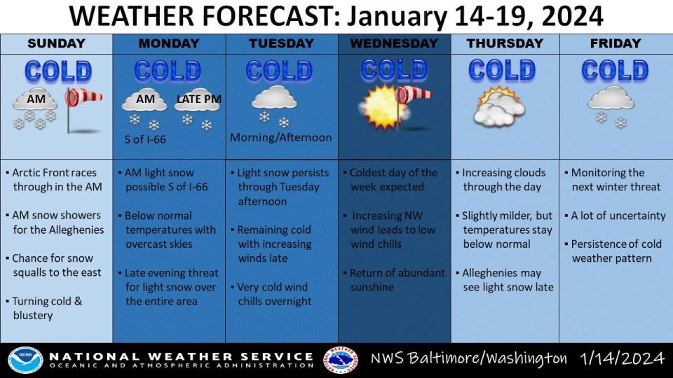
UPDATE as of Sunday morning, Jan. 14, 2024: The National Weather Service is cautioning motorists to consider delaying travel Sunday until later in the afternoon due to the possibility of snow squalls in the Tri-State area in the morning, and in local Pennsylvania, into the early afternoon, according to its website.
The weather service also issued another wind advisory, this one until 3 p.m. Sunday, due to gusts possibly reaching 50 mph to 55 mph in the region.
Concern about dangerously low wind chills arriving in the Tri-State area for multiple days continues. That now includes wind chills possibly reaching 0 to 5 degrees in Southcentral Pennsylvania Sunday night into Monday morning.
There is an enhanced winter storm threat for the local Maryland and West Virginia area Monday night into Tuesday which, if it happens, could affect travel, according to the NWS website.
===================================
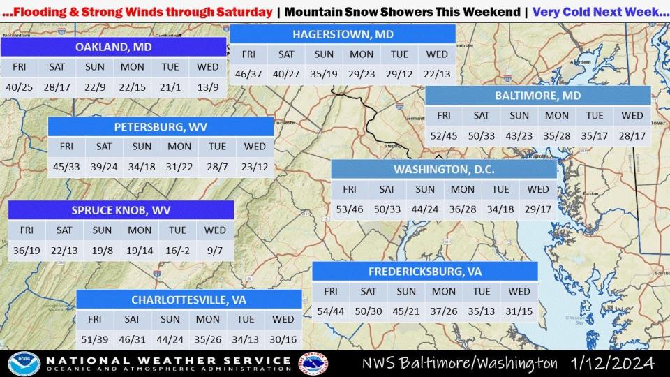
The National Weather Service has issued wind advisories for the Tri-State area on Saturday, with gusts forecast to reach around 50 mph.
Meteorologists also are keeping an eye on a storm system that might bring snow to our area Monday night or Tuesday, if at all.
Temperatures also are expected to dip and remain cold for several days, including dangerously low wind chills in the single digits starting Tuesday night.
Preparing for significant gusts Saturday in Hagerstown, Martinsburg, Chambersburg areas
In the wake of a weather system expected to bring some rain to the Tri-State, there will be winds high enough for the weather service to issue a wind advisory for 7 a.m. to 4 p.m. Saturday.
Mid-morning to mid-afternoon gusts could reach about 50 mph in Washington County and West Virginia's Eastern Panhandle, said meteorologist Dan Hofmann with the Baltimore/Washington Forecast Office.
MyCoast: Maryland app to aid planning: Flooding photographs can be put to good use with Maryland-backed app
The wind advisory is in effect from 7 a.m. to 9 p.m. Saturday for Franklin and Fulton counties in Pennsylvania, where gusts also could reach about 50 mph, said meteorologist Bill Gartner with the State College (Pa.) Forecast Office.
It will still be windy after the advisory periods, though Hofmann said there could be a lull overnight before winds pick back up Sunday. That doesn't mean the winds will be calm through the night, he said.
Wind gusts on Saturday evening and Sunday could reach about 25 mph to 35 mph, Hofmann said.
With the forecasted wind gusts and the ground wet from rain expected through Friday night, there is potential for downed trees and power lines, meteorologists said.
The higher wind gusts also could affect higher-profile traveling vehicles from tractor-trailers to sport utility vehicles, they said. Particularly if there are cross winds, such as along a bridge, or gap winds when a motorist travels between mountain ranges and the wind comes between the ranges.
Winds could blow around unsecured objects.
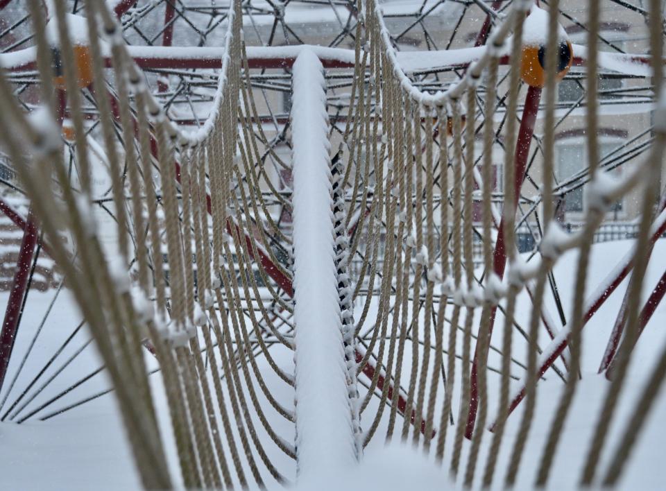
Snow blankets Hagerstown, photo gallery: Snow blankets Hagerstown in first big winter storm of season: PHOTOS
What we know about potential winter storm at end of holiday weekend
As of Friday morning, it was too soon to tell if the storm system near Alaska and Canada's Yukon Territories would bypass the local Tri-State area or bring several inches of snow on Tuesday, Hofmann said.
If there is snow, it could start snowing in Washington County and nearby West Virginia as early as mid to late Monday evening, probably after 8 p.m. or 9 p.m., Hofmann said Friday morning. Or it could start snowing as late as after daybreak Tuesday.
Franklin County, Pa., could be along the northern edge of the storm and get a dusting of snow, or the storm's track could move north and the area could see more snow, Gartner said.
The range of possible scenarios for the early week storm was wider than normal as of Friday morning, Hofmann said.
Meteorologists will get a better idea of the potential impact as the system moves south to the lower 48 states.
What to know on spotted lanternfly: A dangerous hitchhiker: How spotted lanternflies get around
It's January so sustained cold temps are here
The weather service also is forecasting sustained cold temperatures through at least Wednesday, with highs around 46 or lower and lows that are expected to reach the teens on some nights.
A hazardous weather outlook issued by the Baltimore/Washington Forecast Office warned of "dangerously cold wind chills" possible Tuesday night into Wednesday.
The low temperatures alone are expected to be around 12 degrees Tuesday night and around 12 to 13 degrees on Wednesday night in the Tri-State region.
The wind chills those nights could be in the single digits, said meteorologist Brian LaSorsa with the Baltimore/Washington Forecast Office.
The wind chill Thursday night should be warmer, in the teens or lower 20s.
This article originally appeared on The Herald-Mail: Wind gusts and potential snowstorm in Md./Pa./W.Va. area forecast

