Wind, hail, tornadoes and flash floods possible in Tuscaloosa, West Alabama on Tuesday
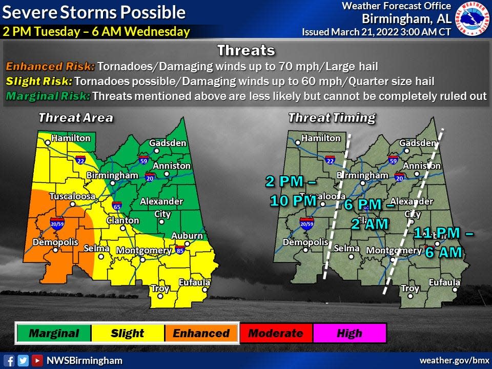
A wave of potentially hazardous storms will cross West Alabama on Tuesday, bringing the threat of what meteorologists called “all modes of hazardous weather” for this time of year.
Tara Goggins, a meteorologist for the National Weather Service in Birmingham, said a strong low-pressure system will come from the west and cross into Tuscaloosa and West Alabama about 2 p.m. Tuesday.
For the next eight hours or so, the possibility of damaging winds, large hail, tornadoes and flash flooding are possible for much of western and central Alabama.
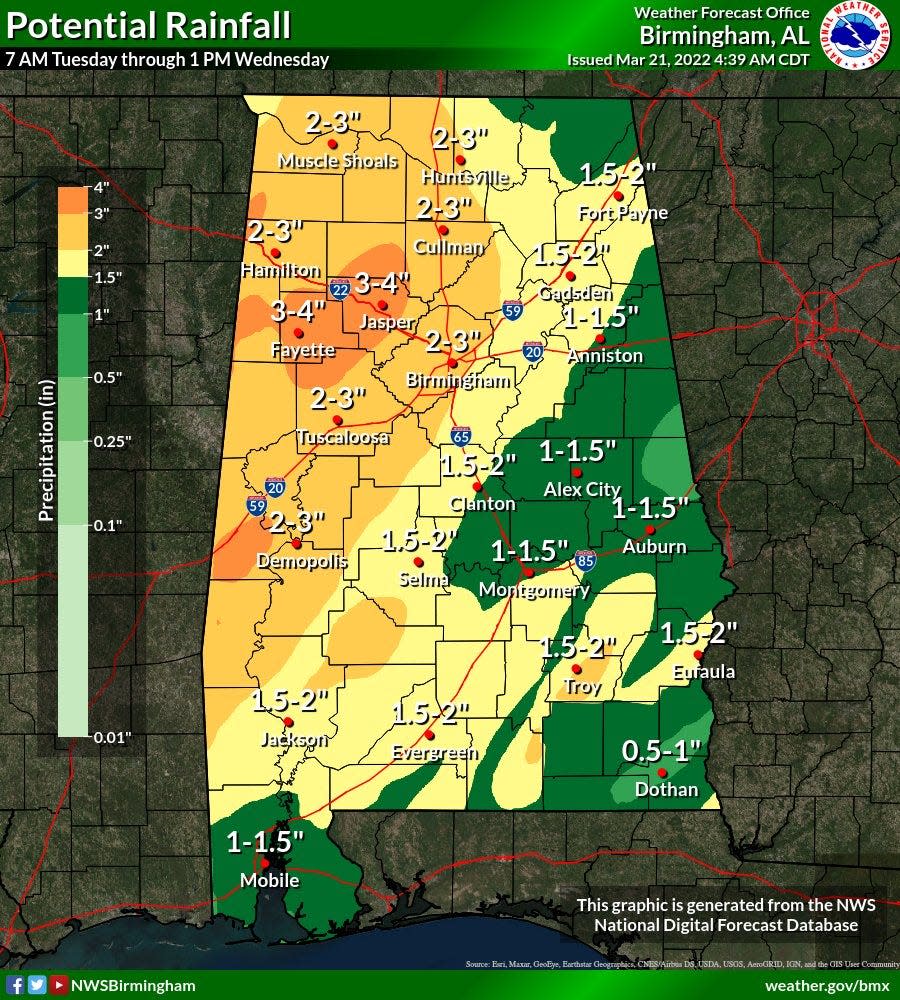
Rainfall totals are expected to range from 3 to 4 inches in northern Tuscaloosa County and portions of Fayette and Walker counties, while the remainder of West Alabama can expect 2 to 3 inches of rain.
Weather warning: Millions at risk as South braces for severe storms, possible tornadoes
“We’re looking at severe storms possibly starting Tuesday afternoon and maybe continuing into the early evening hours,” Goggins said. “The majority of West Alabama, at least up toward Hamilton, is (at) slight risk.”
The low-pressure system is coming from the area of west Texas and eastern Louisiana and will cross through Mississippi on Monday night and early Tuesday before arriving at the Alabama state line.
Goggins said temperatures will hover in the mid-70s leading up to and during the storm, though the lows are expected to drop into the lower 60s or upper 50s when it passes.
Once the low pressure system moves out, temperatures will continue to fall into the lower 40s on both Wednesday night and Thursday night, though no freezes are expected, she said.
Risk categories change across state, but everyone should be prepared
The risk threat categories range from “enhanced” for all of Sumter, Greene, Marengo and Hale counties as well as portions of Perry, Dallas, Bibb, Pickens and Tuscaloosa counties.
The remaining areas fall into the “slight” or “marginal” risk categories, but Goggins urges residents not to get complacent based on these assessments because the possibility of severe weather can strike them all.
“All modes of severe weather” are possible, she said. “We just don’t want people to focus too much on the risk category their county is in.
“We want them to prepare the same.”
That means having multiple ways to receive or hear weather alerts in case one should fail and have an emergency kit ready either in the household’s safe place or easily accessible.
As for safe places, Goggins said residents should ensure everyone in the home knows where the designated safe space is and, if traveling – either to a community shelter or a neighbor’s home – is required, to have that route planned and prepared for.
Lastly, Goggins said meteorologists urge residents to be familiar with the counties of their state so they can know if a storm is approaching or nearby based on reports and alerts.
“And not just their county,” Goggins said, “but surrounding counties, as well, so when warnings are issued they’ll know whether the storm is headed toward them.”
Weather Radar: Track current conditions over Tuscaloosa
The radar below shows current weather conditions over Tuscaloosa.
(Refresh the page for the latest radar loop)

Having trouble seeing the radar? Click this link.
Reach Jason Morton at jason.morton@tuscaloosanews.com.
This article originally appeared on The Tuscaloosa News: Wind, hail, tornadoes, floods possible in Tuscaloosa area Tuesday

