Wind and rain cause damage and power outage across Greater Fall River: Live coverage
FALL RIVER — A powerful storm sweeping across the area today has left homes without power and downed trees and poles across Greater Fall River.
The storm, which traveled up the East Coast over the weekend, is causing lots of damage around Eastern Massachusetts, as wind guests in Massachusetts and Rhode Island have topped 60 miles per hours and have even required Logan Airport in Boston to stop all planes.
"It just turned into a beast in the three or four hours,” said the Department of Community Management’s head Charlie Denmead just before noon about the storm that hit the region overnight.
The large amount of damage reports in Fall River an uprooted tree on Seabury Street that crashed into a telephone pole with a transformer on it, which then crashed into a three-family house at 238 Seabury St.

Five people were displaced from the home across from Ruggles Park on Seabury Street. Yellow police tape ringed the block off with police and a crew from National Grid as well as the Red Cross on scene earlier today. No injuries were reported.
What to know about the power outage at Fall River public schools
Power outages continued around the city including several schools. Silvia Elementary School was about to get power returned at around 12:30 p.m., according to City of Fall River Chief of Staff Ann O’Neil-Souza.
Earlier, power was restored at Green Elementary and Morton Middle School was powered by a generator. Power was out at Spencer Borden Elementary School for a number of hours Monday, and was restored about noon.
When the power initially went out parents were sent the following notice:
I wanted to let everyone know that we lost power at Spencer Borden about five minutes ago. All students are safe in their classrooms and are continuing to work with their teachers. We are following our regular schedule and all students continue to be engaged in their learning. Our teachers and administrative staff are able to communicate with each other by radio and cell phone to continue to ensure everyone’s safety. National Grid is working on the issue in the neighborhood and hopefully we will have power restored soon. I will continue to update families throughout the morning via ParentSquare.
Where else is there storm damage around Fall River
Another pole was nearly downed on Bay Street in the area of Gold Medal Bakery with a truck blocking off the area where the pole was swaying in the wind. The area of Weetamoe at North Main Street was blocked off due downed power lines earlier. Another tree fell on Wayland Street in Fall River.

A former mill building on Front Street was shut down on Monday morning due to debris falling from the roof. Fire crews also responded to the T.J. Maxx on William S. Canning Blvd. at South Coast Marketplace where debris was hanging from the roof due to the winds tearing through the area.
Denmead said DCM crews were out picking up debris along with staff from the Cemeteries and Parks Department. He said at least one private tree removal company was working.
What to do if you have a downed tree in Fall River
To report a downed tree, call the Department of Community Maintenance at 508-324-2762.
Things in Swansea were a bit of a mess
Police Chief Marc Haslam said he truly believes that his department was getting more calls than it does during many hurricanes.
"From 6 a.m. until now (2:30 p.m.) we've responded to almost 40 calls of downed wires and trees," said Haslam.
He said there were two structure fires in the Mount Fair Circle area and he knew of four homes struck by trees.
He said it was a scary few moments when a call came in that a school bus was struck by downed electric wires on Stony Hill Road. To responders relief, it wasn't true, but a tree did fall behind a bus. No one was injured and the bus and its cargo was able to go on its way, said Haslam.
And crews had to shut down the Bungtown Bridge over the Palmer River swelling.
Haslam said earlier Monday a motorist drove around the bridge and got stuck in the flood and had to get out with assistance.
Swansea Town Administrator Mallory Aronstein said a Town Hall worker discovered the power was off there. When Aronstein arrived to work, the power was back on, but the fire alarm was going off, tripped by the power failure.
And the Town Hall sign didn't fair very well. She said staff watched while the wind blew the sign off, landing in the street and breaking.
The storm also caused the Town Hall roof to leak.
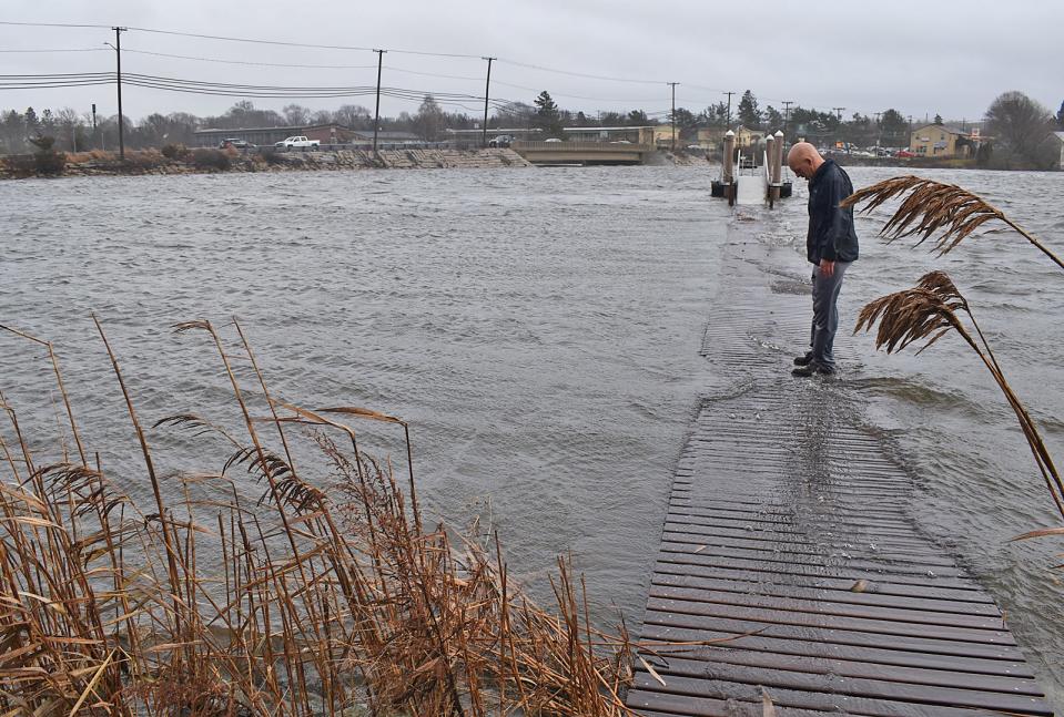
Also, a part of Route 6 in front of the Venus di Milo was closed to traffic due to flooding.
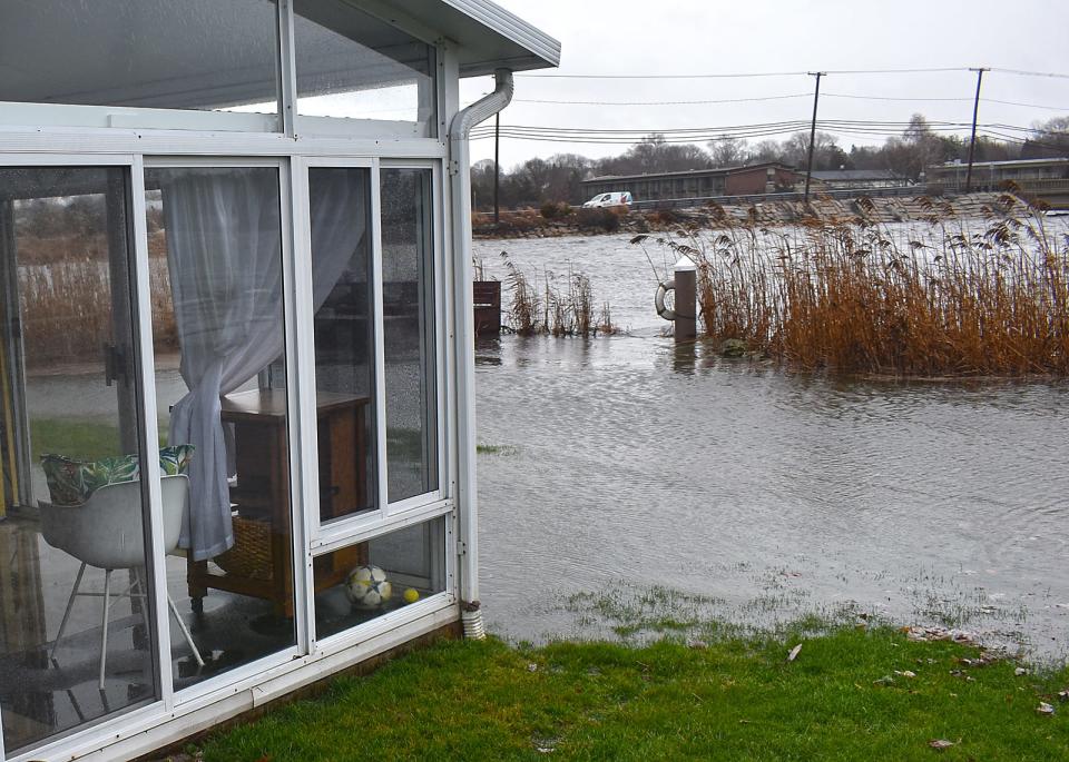
Residents who live along the water in Swansea were dealing with flooded backyards Monday at high tide in addition to a power outage in the Ocean Grove area that had about 2400 people without power for 3 hours.
Minor damage reported in Somerset
In Somerset, Police Chief Todd Costa said was a minor storm surge along the River, but nothing major.
There were reported downed trees and a couple of poles, he said.
Power outages are a moving target on the Southcoast of Massachusetts
National Grid is reporting that about 4,085 customers were out in Fall River just before 11 a.m. Monday and 17,649 customers were out in Bristol County as a whole. This number had risen to 28,251 customers out of power in Bristol County by noon, but had dropped in Fall River to just under 3,000 (2,993).
Power outages in Massachusetts: Bristol County, Massachusetts Power Outage Tracker
Earlier this morning, National Grid was reporting more than 2,000 people without power in the Swansea-Somerset area. Currently, there are more than 2,000 people without power in North Main Street President Avenue, down from more than 4,000 earlier this morning.
What to expect from the weather for the rest of Monday
The forecast is that peak wind gusts, along with heavy rain, will continue through early this afternoon, according to StormTeam 5. The wind will continue through the evening commute but the rain should have lessened.
StormTeam 5 will also be monitoring the midday and afternoon high tide for the potential for minor to moderate coastal flooding for south-facing beaches.
Areas near Narragansett Bay are under a coastal flood warning. Parts of Cape Ann, as well as the New Hampshire Seacoast and the southern Maine coast, may also experience coastal flooding during the mid-afternoon high tide.
High Wind Gust Record in Milton: 90 mph sets a new record
Matt Douglas, the chief observer at Blue Hill Observatory and Science Center, has been tweeting out updates throughout the morning. A new official peak guest for the date was set at 11:33 a.m. Monday, Dec. 18.
“New official peak here at BHO 90mph at 11:33am. It is absolutely wild up here!,” he tweeted.
The prior record for peak guest for the date was 76 miles per hours and was set in 1978.
The record for December is 95 miles per hours, which was set on Dec. 29, 1966. If the wind guests reach 100 miles per hour, then it will be the first time since 1985.
The Blue Hill Observatory is at 635 feet of elevation, which is the high point east of I-495 in Massachusetts.
What Jim Cantore is saying about the storm in Massachusetts
The Weather Channel’s Jim Cantore, possible the most famous meteorologist in the United States, is keeping eye on the storm that is hitting Massachusetts.
This morning he retweeted a post by the Duxbury Fire Department as they warned residents to keep away from live wires.
“#DXFD is responding to numerous weather related calls. Please treat all wires as if they are live and never drive under trees on wires,” reads the tweet, on X, the platform formerly known as Twitter.
East Beach Road at East Horseneck Beach last half hour with high tide approaching in Westport @ericfisher @JimCantore @spann @MatthewCappucci @Eweather13 @mfdwx pic.twitter.com/puz6KOk1gB
— Nishan Bilazarian (@nishmanweather) December 18, 2023
He also retweeted Nishan Bilazarian’s post from Westport, which shows images of a flooded East Beach Road at East Horseneck Beach, at about 11:50 a.m. and a half-hour before high tide.
What is the National Weather Service reporting for wind and rainfall totals?
The National Weather Service released the wind and rainfall reports as of 2 p.m. for Massachusetts. The “observations are collected from a variety of sources with varying equipment and exposures. … Not all data listed are considered official,” according to the service.
As of 2 p.m., Ashfield in Franklin County had the highest report with 4.8 inches.
Here are amounts reported in Bristol County:
S Lakeville: 2.34 inches as of 7:55 a.m.
Taunton Airport: 2.17 inches as of 1:26 p.m.
Dighton: 1.90 inches as of 8 a.m.
New Bedford Airport: 1.86 inches as of 1:42 p.m.
Rehoboth: 1.81 inches as of 7 a.m.
New Bedford: 1.73 inches as of 7 a.m.
Somerset: 1.73 inches as of 7 a.m.
Dighton: 1.70 inches as of 8 a.m.
Attleboro: 1.65 inches as of 8:19 a.m.
Norton: 1.64 inches as of 7 a.m.
Mansfield: 1.63 inches as of 6 a.m.
Westport: 1.60 inches as of 7 a.m.
NWS Boston/Norton: 1.45 inches as of 7 a.m.
Somerset: 1.31 inches as of 6 a.m.
Taunton: 1.29 inches as of 7 a.m.
Mansfield: 1.21 inches as of 5 a.m.
Westport: 1.16 inches as of 8:35 a.m.
Dartmouth: 1.10 inches as of 7 a.m.
Fairhaven: 0.85 inches as of 8 a.m.
Top Wind Gusts in Massachusetts
Here are the top wind guests in Eastern Massachusetts as of the 2 p.m. public information statement by the National Weather Service on Dec. 18.
Bristol County
Dighton: 66 MPH at 10:26 a.m.
Taunton Airport: 63 MPH at 11 a.m.
New Bedford Airport: 62 MPH at 10:34 a.m.
Norfolk County
Blue Hill Observatory: 90 MPH at 11:38 a.m.
Norwood Airport: 67 MPH at 10:35 a.m.
Weymouth: 63 MPH at 10:38 a.m.
Plymouth County
Plymouth Airport: 60 MPH at 9:15 a.m.
Marshfield Airport: 52 MPH at 12:55 p.m.
Hanson: 50 MPH at 11:58 a.m.
Suffolk County
Logan Airport: 68 MPH 10:53 a.m.
This article originally appeared on The Herald News: Fall River live coverage: Power outages, roads closures, trees down

