Winter's revenge: Arctic plunge to bring snow opportunities to eastern US through mid-December
Once arctic air infiltrates the eastern United States later this week, it will hold firm through at least the middle of December and bring opportunities for snow.
Residents of the East may want to take advantage of the surge of milder air early this week to put up Christmas decorations. The days of not needing heavier jackets and saving on heating costs are coming to an end.
The arctic express will not stop after it plunges into the Midwest early this week. The cold will continue to expand eastward through the week, dramatically slashing temperatures, even down to the Florida Peninsula.
Once the cold settles in, highs will be 20-30 degrees Fahrenheit lower when compared to early this week.
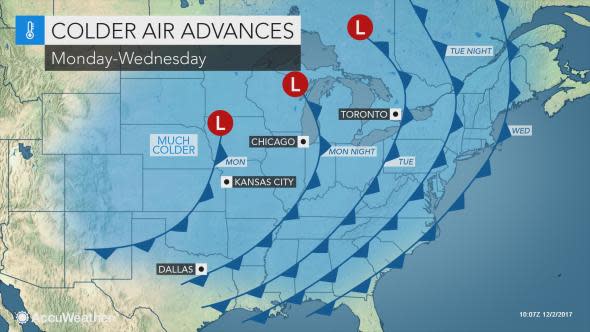
The cold is expected to spread across the South and into the Northeast at midweek, following a band of soaking rain.
As the cold air catches up with the back edge of the rain, snow may briefly fall in the higher terrain of the central and northern Appalachian Mountains Tuesday night into Wednesday morning.
Later this week, temperatures will struggle to climb much above freezing across the interior Northeast from Burlington, Vermont, to Buffalo and Albany, New York, to Pittsburgh.
Late-week highs will also range from near 40 F in Boston to the lower 40s in New York City to near 50 in Raleigh, North Carolina, and Atlanta.
In the wake of rain riding along the Gulf and Southeast coasts later in the week, the colder air will eventually seep across the Florida Peninsula. Temperatures may struggle to reach 60 in Tampa and Orlando to end the week.
Highs in early December typically range from the 30s in northern New England to a few degrees around the 50-degree mark in the mid-Atlantic to the upper 50s and lower 60s in the Carolinas and the 70s in the Florida Peninsula.
Outside of the Midwest, fierce winds are not expected to usher in the initial wave of arctic air. That will prevent AccuWeather RealFeel® Temperatures from being significantly lower.
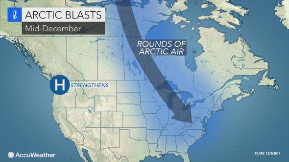
"Unlike previous events earlier this fall, the cold arriving at midweek will be slow to leave," AccuWeather Long-Range Meteorologist Max Vido said.
"Through mid-December and potentially right up to the winter solstice (on Dec. 21), residents across the eastern U.S. will have to contend with the cold weather," he said.
Vido expects temperatures to continue to average 5-10 degrees below normal across the eastern U.S. through the middle of the month.
Waves of cold to bring snow opportunities
"The cold air will support several chances for snow in the Midwest, Ohio Valley and Northeast over the next few weeks," Vido said. "While this can provide some seasonal cheer, it may also cause travel disruptions before the holidays."
Around the Great Lakes, the opportunity for snow will come as soon as the cold blasts in.
"As cold air surges over the Great Lakes toward the middle and end of this week, bands of lake-effect snow will set up downwind of the lakes," AccuWeather Meteorologist Steve Travis said.
"Places that will pick up the heaviest snow are the Tug Hill Plateau downwind of Lake Ontario, the south towns of Buffalo, New York, and northern Michigan," he said.
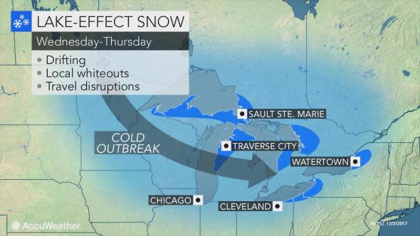
The most persistent snow bands may unload a foot or more of snow in these locations.
Motorists planning to travel on stretches of Interstate 75, I-81 and I-90 downwind of the Great Lakes should be prepared for difficult travel and a sudden reduction in visibility.
Later in the week, AccuWeather meteorologists are monitoring the possibility of the storm delivering rain to the Southeast coast to turn northward and graze the Northeast coast with snow or rain.
At the same time, a weak clipper storm from Canada may dive into the Midwest with an area of nuisance snow. The Northeast may be the next stop for this snow next weekend, especially if the storm gains strength.
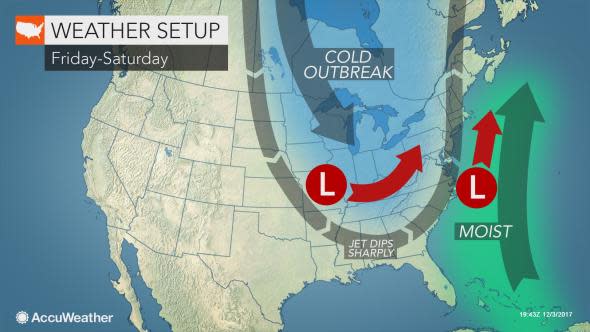
Whether any snow events in the middle of December come from additional clipper storms sweeping from the Midwest to the Northeast or major storms tracking northeastward from the South Central states will depend on the jet stream pattern, according to AccuWeather Senior Meteorologist Alex Sosnowski.
