What will winter bring to Sacramento after a year of heavy rain and snow in California?
California is nearly drought-free as the 2022-23 water year has come to a close with well-above-normal precipitation totals.
California’s water year runs from Oct. 1 to Sept. 30. Hydrologic forecaster Brett Whitin with the California Nevada River Forecast Center said a vast majority of Sacramento and El Dorado counties wrapped the previous water year between 130% and 150% of normal precipitation.
Totals in the Tahoe region ranged from 150% to 200%.
California’s wet winter came due to a string of aggressive atmospheric river storms in early 2023.
In January, the state endured record-breaking rainfall that caused flooding, left people without power, destroyed homes and killed close to 20 people, including several in Sacramento County. Winter storms that continued through March created the deepest snowpack recorded across the Sierra Nevada in at least 40 years.
Water year 2022-23 ended this weekend (Sept 30) with above normal precipitation for most of CA (except far Nrn) and for SW and NE NV. Over 40 inches above normal in some areas of the Srn Sierra and Big Sur Coast and Santa Ynez and San Bernardino Mtns. #cawx #nvwx #cawater pic.twitter.com/V7OT8TJ5YA
— NWS California-Nevada RFC (@NWSCNRFC) October 2, 2023
Cooperative observers in Sacramento measured roughly 26.2 inches of precipitation during the 2022-23 water year, according to a water year summary from the California Nevada River Forecast Center.
Placerville measured nearly 46 inches of precipitation and Auburn saw about 39 inches. Observers in Tahoe City measured roughly 46 inches.
Portions of Northern California near the Oregon border received below normal precipitation for the water year.
September data isn’t yet available from the forecast center. Totals were last updated early Tuesday morning.
Here’s the statewide summary for the 2022-23 water year, according to the California Department of Water Resources:
Statewide precipitation
▪ Precipitation total: 33.56 inches
▪ Percent of historical average: 141%
Statewide reservoir storage
▪ Total at end of water year: 27.4 million acre-feet
▪ Percent of historical average: 128%
Statewide snowpack
▪ Percent of historical average annual maximum: 247%
▪ Percent of historical average on April 1: 237%
Where do drought conditions and reservoirs stand?
“We’re looking much better from a reservoir storage standpoint — much better right now than we were a year ago today,” said Whitin, who analyzes both short- and long-range forecasts for the water supplies of major reservoirs across California.
A large amount of precipitation measured at higher elevations came in the form of snow. It was colder than rain and generated a record-breaking snowpack in the southern Sierra.
According to the U.S. Drought Monitor, California is roughly 99.9% drought-free with less than 1% of the state in “moderate drought,” in the most northern portion of the state — Del Norte County.
California is free of severe, extreme and exceptional drought conditions, according to the federal monitor.
What will winter bring?
“That’s a hard one to really know,” Whitin said.
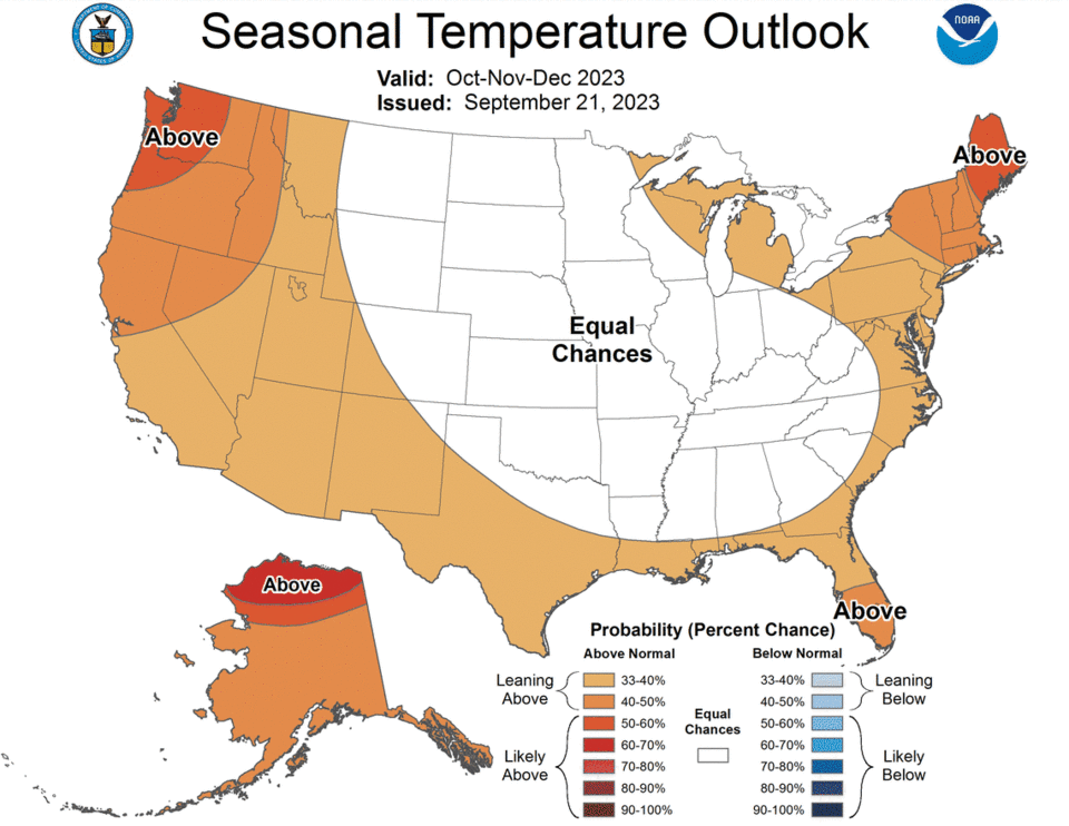
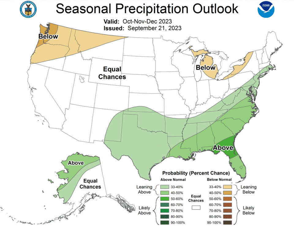
According to the National Oceanic and Atmospheric Administration, there’s between a 33% and 40% chance temperatures in California will lean above normal for this time of year. NOAA outlooks show “equal” chances of above-normal, near-normal or below-normal rainfall for October in the northern portion of the state.
Southern California could see more rain.
October is noted as the “lowest predictable month” for both temperatures and rainfall amounts, but meteorologists are preparing for a “near certain” El Niño winter, according to the National Weather Service.
“That doesn’t necessarily mean we’ll have above normal precipitation,” Whitin said.
El Niño and La Niña are weather phenomena that can influence weather predictions across the globe, according to previous Sacramento Bee reporting. During El Niño, abnormally warm sea surface temperatures occur in the Pacific Ocean, while La Niña happens when sea temperatures are cooler than usual in the central and eastern tropical Pacific Ocean.
There have been strong El Niño years without above normal rainfall, Whitin said, most recently in 2016.
If there is a signal for above normal precipitation for strong El Niño years, the correction is typically the strongest in Southern California.
What do you want to know about life in Sacramento? Ask our service journalism team your top-of-mind questions in the module below or email servicejournalists@sacbee.com.

