Winter is not over. Tri-Cities snow possible. Warning for Gorge and I-90 pass travelers
The Tri-Cities might get some snow this week, and travelers crossing the Cascade Mountains to Western Washington should definitely be prepared for snow.
Travelers heading toward Portland from the Tri-Cities could see some of the worst road conditions. Freezing rain is forecast in part of the Columbia River Gorge on Presidents Day weekend.
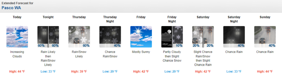
The National Weather Service predicts a 60% chance of precipitation in the Tri-Cities Wednesday night and Thursday morning, which could fall as rain or snow.
The snow level is forecast to drop to 600 feet overnight Wednesday. Much of the Tri-Cities is about 400 feet, but the elevation rises to 1,000 feet just south of Kennewick at the Interstate 82 and Highway 395 junction.

New snow of less than an half inch is forecast with up to a half inch more at some higher elevations in the Tri-Cities area.
Thursday another half inch of snow is possible by 1 p.m. Any accumulation should melt quickly.
Highs should reach no more than 39 degrees as the storm system moves through the Tri-Cities Thursday, with highs back in the low to mid 40s Friday through the holiday weekend.
Lows should be within a few degrees above or below freezing through Monday night.
Normal highs for mid February in the Tri-Cities are about 49 and normal lows are near 28.
A slight chance of rain or snow is forecast Saturday morning, followed by a 40% chance of rain Sunday and a cloudy but dry Washington’s Birthday on Monday.
I-90 Snoqualmie pass forecast
A winter weather advisory is issued for Snoqualmie Pass on Interstate 90 in the Cascade Mountains of Washington through 4 a.m. Friday morning.
The weather service expects 1 to 2 inches of new snow Wednesday night and again Thursday, with just a half inch of new snow overnight Thursday.

The storm should drop most of its snow in the mountains south of Snoqualmie Pass, where total accumulations of 8 to 14 inches are forecast.
After the storm system passes, people heading to western Washington for the long weekend can expect a slight chance of snow Friday and then periods of rain and snow through Monday.
I-84 Gorge forecast
Travelers heading west from the Tri-Cities through the Columbia River Gorge on Interstate 84 should be prepared for snow and then roads that are icy with a wintry mix of snow and freezing rain.
A winter storm warning had been issued at Hood River, Ore., on I-84, with 3 to 5 inches of new snow possible Wednesday night and then 2 to 4 inches on Thursday.
Friday morning a slight chance of a wintry mix of snow and freezing rain is possible, with chances increasing to 60% on Saturday.
The weather service forecasts a chance of freezing rain and and possible snow at times through the weekend on I-84 at Hood River.
I-84 Blue Mountain forecast
Interstate 84 through the Blue Mountains also is under a winter weather advisory until early Friday morning.
Near the summit by Meacham, Ore., 1 to 3 inches of new snow is forecast by the weather service Wednesday night, with less than a half inch of snow forecast Thursday and again Thursday night.
Up to 10 inches of new snow is forecast elsewhere for some of the Blue Mountains above 4,000 feet elevation.
The chance of snow on I-84 near Meacham drops to 20% Friday morning, and only a slight chance of snow is forecast Saturday, with rain more likely.
Rain could be mixed with snow Saturday night, but the rest of the three-day weekend should see only rain.

