Winter storm advisory: Slippery roads expected as 3-5 inches of snow to fall in Canton
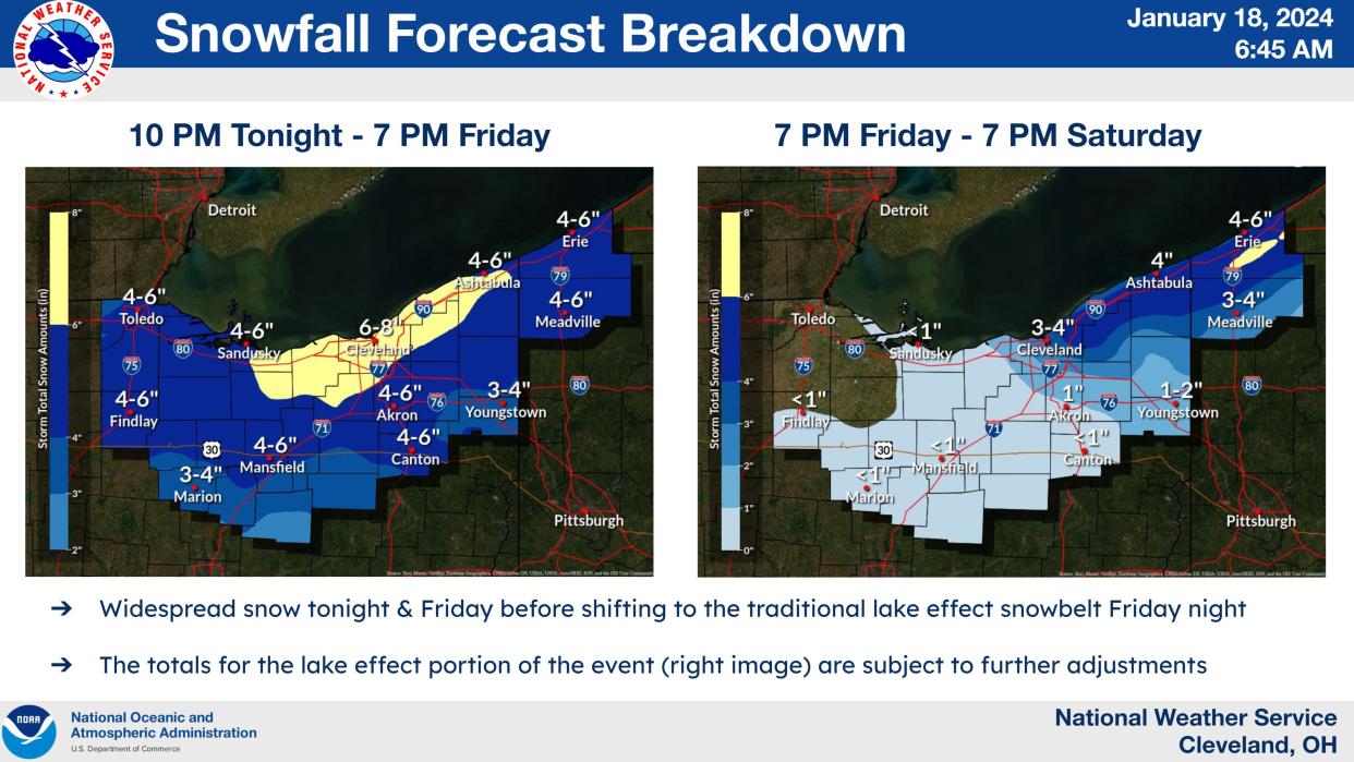
Driving north to Akron or Cleveland today? Good luck, as a major snowstorm was expected to dump up to 8 inches across Northern Ohio.
The Canton region won't escape the snowstorm, with the area expected to receive 3 to 5 inches.
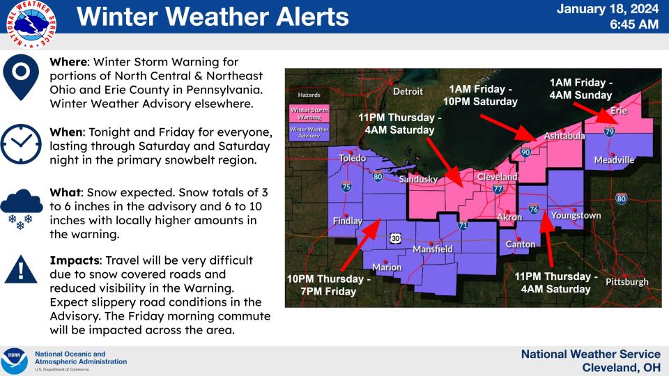
The National Weather Service issued a winter weather advisory for Stark, Portage, Trumbull and Mahoning counties. The advisory will be in effect from 1 a.m. today to 4 a.m. Saturday.

Stark County road forecast: slippery
The weather service advises motorists to plan on slippery road conditions. The hazardous conditions could affect morning and evening commutes.
The steadiest snow was expected overnight into this morning, including during the morning commute. Occasional snow showers will continue this afternoon through much of tonight.
Communities plan parking bans
Canton and Jackson, Plain and Osnaburg townships announced on-street parking bans for periods when snow removal is expected.
The city of Canton has banned street parking from 12:01 a.m. today to 12:01 p.m. Saturday.
"This ban is for the safety of plow drivers and first responders and will help plow drivers clear the roads more safely and efficiently," said the announcement from the office of Mayor William V. Sherer II.
Those with driveways, garages and other means of off-street parking are asked to refrain from parking on the street. Where possible, those without off-street parking options are being asked to park on the side of the street with even-numbered addresses.
Those who work downtown, or will visit the area, are asked to use surface parking lots or a parking deck, as downtown is included in the parking ban.
"Please refrain from traveling unless absolutely necessary," the announcement from the mayor's office said. "It is recommended that all public events planned during this ban be canceled. Any vehicles that are found in violation of the parking ban may be ticketed or towed."
The Osnaburg Township parking ban extends from 4 p.m. Thursday to 4 p.m. Saturday on township roads. Residents are also instructed to remove portable basketball hoops from roads.
Plain Township is prohibiting parking on township roads from 11 p.m. Thursday through 11 a.m. Saturday.
"This ban is for the safety of our plow drivers, safety services/first responders and the traveling public. This will also increase the plow driver's ability to clear the roads at a faster pace," Plain Township Highway Superintendent JR Neff wrote in announcing the ban.
Vehicles found in violation of the parking ban may be ticketed or towed by Stark County sheriff’s deputies.
Parking on Jackson Township streets is prohibited from 10 p.m. Thursday through 8 a.m. Saturday.
Alliance also warned residents that a ban would be enforced if snow accumulation reaches four inches or greater. Any parking ban in the city would be preceded by a minimum of a one-hour public notice, and residents can register for mobile notifications at https://oh-alliance.app.regroup.com/login.
Storm warning for counties closer to Lake Erie
Areas to the north are expecting more snow starting earlier.
The National Weather Service issued a winter storm warning for Medina, Summit, Lorain, Cuyahoga, Erie and Huron counties from 11 p.m. Thursday through 4 a.m. Saturday. Heavy snow is expected with anywhere from 5 to 8 inches.
The wind will be a problem too with gusts as high as 30 mph.
Wind chills as low as 5 to 15 degrees below zero are expected.
"If you must travel, keep an extra flashlight, food, and water in your vehicle in case of an emergency," the weather service advises.
What will the wind chill be like in the Canton area?
The wind will be less of a problem in the Canton area. Wind chills as low as 6 degrees below zero are expected tonight.
What's the forecast?
Thursday: A slight chance of snow showers. Cloudy, with a high near 27. Southwest wind 9 to 11 mph. Chance of precipitation is 20%.
Thursday night: Snow showers, mainly after 1 a.m. Low around 21. Light and variable wind. Chance of precipitation is 100%. New snow accumulation of 1 to 3 inches possible.
Friday: Snow showers. High near 26. Northwest wind 5 to 14 mph in the morning. Chance of precipitation is 100%. New snow accumulation of 2 to 4 inches possible.
Friday night: Snow showers likely, mainly before 1 a.m. Cloudy, with a low around 7. Wind chill values as low as minus 6. West wind 11 to 14 mph. Chance of precipitation is 60%. New snow accumulation of less than half an inch possible.
Saturday: A slight chance of snow showers after 1 p.m. Partly sunny, with a high near 17. West wind 11 to 16 mph. Chance of precipitation is 20%.
Saturday night: Mostly cloudy, with a low around 12.
Sunday: Partly sunny, with a high near 24.
Sunday night: Partly cloudy, with a low around 13.
Monday: Partly sunny, with a high near 34.
Monday night: A chance of snow showers after 1 a.m. Mostly cloudy, with a low around 28. Chance of precipitation is 40%.
Tuesday: Rain and snow showers likely. Cloudy, with a high near 40. Chance of precipitation is 70%.
Tuesday night: Showers likely. Cloudy, with a low around 35. Chance of precipitation is 70%.
Wednesday: Showers likely. Cloudy, with a high near 46. Chance of precipitation is 60%.
Check Canton weather hourly
Listen to a weather radio or go to weather.gov on the internet for more information about the storm's hazards.
This article originally appeared on Akron Beacon Journal: Winter storm advisory for Stark County early Friday into Saturday

