A winter storm continues to head toward Iowa. When and how much snow could we see?
Iowa may finally be getting some snow and portions of the state might see as much as a foot of fresh snow. The National Weather Service in Des Moines is preparing for "impactful snowfall" starting on Sunday night into Tuesday.
NEW UPDATES: This file is no longer being updated. Follow the newest updates here.
Forecasters at the NWS released a weather briefing to help Iowans prepare for possible hazardous weather.
When will snow come to Des Moines and central Iowa?
A light dusting of snow fell overnight Friday into Saturday morning. Another light band brought a trace of snow to central Iowa on Saturday night.
Afternoon forecast updates: slight increase in snow totals and conversion of Winter Storm Watch to a Winter Storm Warning/Advisory.
Now is the time to make final preparations ahead of the storm. Stay safe! #iawx pic.twitter.com/uCNXqpMdHi— NWS Des Moines (@NWSDesMoines) January 7, 2024
A bigger storm, which has been the subject of social media posts and rumors, remains on track to affect the Plains on Monday and Tuesday, according to the NWS. The highest snowfall is to hit southern and eastern Iowa.
What are the winter storm watches and warnings associated with this snowstorm in Iowa?
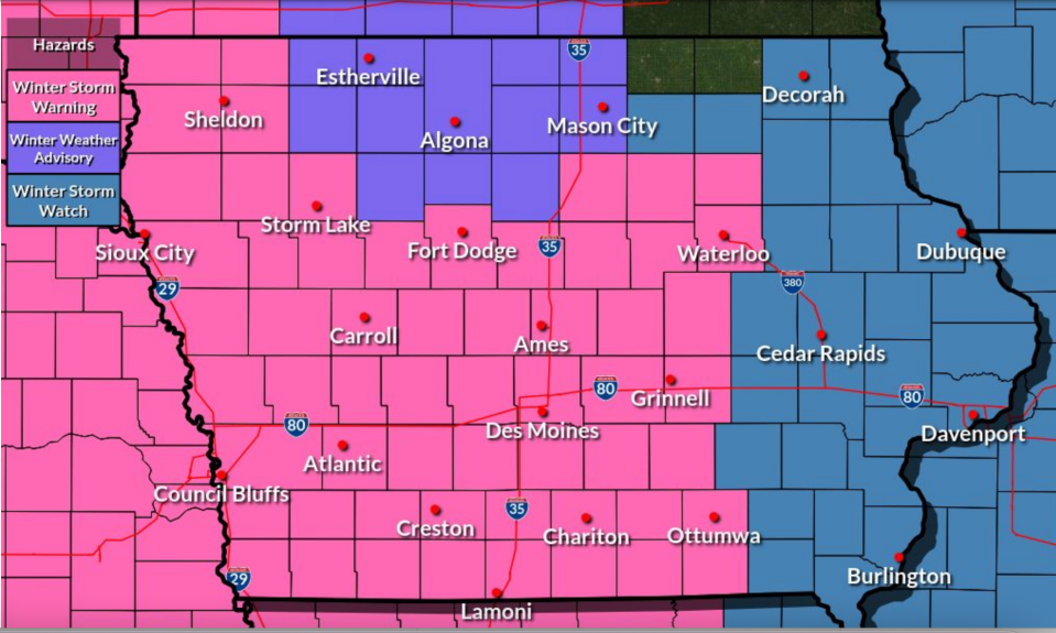
As confidence continues to increase in the track of the storm, the National Weather Service has issued a winter storm warning for most of western and central Iowa. Areas in eastern Iowa, which are expected to get some of the highest snowfall totals are under a winter storm watch.
The weather service warns that travel will be hazardous at times, especially during the Monday evening and Tuesday morning commutes.
Snowfall rates of 1 inch per hour are possible at times in southeast Iowa.
A Winter Storm Watch is in effect for the entire area Monday night through Wednesday morning. Know the difference between winter headline types such as watches and warnings.⚠️❄️ pic.twitter.com/6h6fHiY7b5
— NWS Quad Cities (@NWSQuadCities) January 7, 2024
More: How to check Iowa road conditions, DOT cameras amid winter storms
Winds will also pick up as the storm moves through, creating a chance for blowing and drifting snow and hazardous conditions.
How much snow could Des Moines get?
The track of the storm has shifted to the north, bringing a greater chance of snow to Des Moines.
Earlier forecasts anticipated a wintry mix limiting snowfall totals in Des Moines. That potential is decreasing, but Des Moines could still see a mix Monday afternoon. Des Moines has a high likelihood of heavy snowfall Monday evening into Tuesday morning.
Des Moines is likely to see 6-11 inches of snow, with the highest probability of 6 inches or more coming to the south and east of the capital city.
More: Winter storm could have you driving in the snow again. These tips can help keep you safe.
How much snow could Ames get?
As forecast track has shifted north during the day on Sunday, Ames is moving into higher snowfall targets. As of Sunday afternoon, Ames' forecast expects 5-10 inches of snow with the highest likelihood of snow coming in the later afternoon and evening hours on Monday through early Tuesday morning.
How much snow could Iowa City get?
A prolonged strong winter storm is expected Monday night through Wednesday morning. Accumulating snow and blowing and drifting snow is possible. A winter storm watch is in effect. pic.twitter.com/IrO2BurRIK
— NWS Quad Cities (@NWSQuadCities) January 7, 2024
The heaviest bands of snow look to hit to the south and east of Iowa City. But, there will still be plenty of snow falling in Johnson County. The latest forecast, released Sunday afternoon, calls for 7-12 inches through the area
Des Moines Register reporter Biong M. Biong contributed to this report.
Victoria Reyna-Rodriguez is a general assignment reporter for the Register. Reach her at vreynarodriguez@registermedia.com or follow her on Twitter @VictoriaReynaR.
This article originally appeared on Des Moines Register: Des Moines faces snowstorm this weekend through Tuesday, NWS says

