Live updates: Sioux Falls sees record-breaking snowfall; dangerous wind chills ahead
8:15 a.m. Tuesday: The Sioux Falls area saw a record breaking total of 10.5 inches of snow Monday, with another .3 inches since midnight, according to the NWS.
And though the winter storm warning has expired, a winter storm advisory remains in effect until noon today, because of blowing snow and possible additional accumulations of less than an inch, the NWS stated.
Here are today's headlines.
While some new snowfall will be possible near and east of a Sioux City to Marshall MN line (less than an inch) some patchy blowing and drifting snow will remain possible through the day.
Drive safely! pic.twitter.com/PZJld6xZdX— NWS Sioux Falls (@NWSSiouxFalls) January 9, 2024
The Washington Pavilion and Orpheum Theater remain closed Tuesday, because of unsafe road conditions.
Multiple school districts across Minnehaha and Lincoln counties also remained closed for a second day.
Roads throughout the area remain icy, slippery and frost-covered, according to SD511.org, the state's road conditoon tracker.
More snow is anticipated Wednesday and Friday as temperatures plummet, but the chance for more than an inch is currently low, the NWS states.
Dangerous wind chills are also likely this weekend, with wind chill values between -20 and -35 degrees, especially Saturday and Sunday, NWS states.

Weather
Embedded content: https://radar.weather.gov/ridge/standard/KFSD_loop.gif
5:45 p.m. Monday: With 9 inches on the ground in Sioux Falls and more snow expected through early Tuesday, school districts within the city are starting to announce delays for classes Tuesday morning.
These districts have announced two-hour delays so far:
Bishop O'Gorman Catholic Schools
Dell Rapids School District
Dell Rapids-St. Mary's School
Harrisburg School District
Parker School District
Sioux Falls Christian Academy
Sioux Falls Lutheran School
Sioux Falls School District
Tri-Valley School District
Westside Christian
3:15 p.m. Monday: As of this afternoon, Sioux Falls had received a little less than 9 inches of snow, with more expected this evening.
The weather has also forced Great Shots to close at 5 p.m. resulting in the cancellation of the University of Sioux Falls’ watch party for the College Football Playoff National Championship, according to an email from the university. The watch party would have been supporting the four members of the Washington Huskies' coaching staff with ties to USF.
2 p.m. Monday: Sioux Falls is now under a snow alert, meaning cars will need to be moved off city streets as plowing begins early Tuesday morning. The city's snow alert tracker should let you see when a street has been cleared — albeit with a delay of an hour or two.
Noon on Monday: Sioux Falls has reached a total of 8.3 inches so far, according to the NWS.
10:50 a.m. Monday: The NWs has extended its winter storm warning to now include Jackson and Cottonwood counties.
The warning we're expected to see another 4 to 7 inches of snow through the early hours of Tuesday morning.
"Travel conditions will deteriorate through the remainder of the morning as snow intensifies," the NWS stated on social media.
❄️The winter storm warning has been expanded to include Jackson and Cottonwood counties. We are expecting an additional 4-7 inches of snow from late this morning through tonight. Travel conditions will deteriorate through the remainder of the morning as snow intensifies. pic.twitter.com/DmIEZtsSgD
— NWS Sioux Falls (@NWSSiouxFalls) January 8, 2024
10 a.m. Monday: The NWS says another wave of snow is starting to develop, which will make road conditions deteriorate rapidly.
Visibility will be down to less than a mile in some areas as the new snow band moves from the northwest into southeastern South Dakota and roads become snow-covered once more.
10 AM UPDATE: Another area of snow has developed across eastern Nebraska and northwestern Iowa and is moving northwest into Minnesota and southeastern South Dakota. Conditions will rapidly deteriorate with visibilities less than a mile and roads becoming snow covered. pic.twitter.com/JH2BzUNtkE
— NWS Sioux Falls (@NWSSiouxFalls) January 8, 2024
9:30 a.m. Monday: The Washington Pavilion of Arts & Science and Orpheum Theater Center is closed because of the storm.
This closure includes the Kirby Science Discovery Center, Wells Fargo CineDome & Sweetman Planetarium, Visual Arts Center, Box Office, Graham Academy Preschool and The WP café.
As of 9 a.m., the area had received about 8 inches of snow, with more anticipated throughout the day, according to NWS.
9 a.m. Monday: The Sioux Falls School District announced it has canceled the school board work session scheduled for 2:30 p.m. at the CTE Academy, and the school board meeting scheduled for 5:30 p.m. at the Instructional Planning Center.
The work session is tentatively postponed until Jan. 22. An option will be found next week for school board members to hold the business portion of their meeting, and the agenda items slated for Monday's superintendent's report will instead be presented at the regular Jan. 22 school board meeting.
8:40 a.m. Monday: The Lincoln County Courthouse is closed today due to weather conditions.
The Minnehaha County Courthouse is still open at this time.
Timing the snow through today shows:
- A lull/lighter snow amounts for the rest of this morning
- Light to moderate snow filling in from the south this afternoon and tonight
- Heaviest snow for northeast NE and northwest IA comes this afternoon and evening pic.twitter.com/b6UaHNhRoD— NWS Sioux Falls (@NWSSiouxFalls) January 8, 2024
Meanwhile, Mayor Paul TenHaken has urged Sioux Falls residents not to travel today if they do not have to, and to give snow plows time and patience to manuever the roads.
Southeastern Technical College has also since closed for the day.
A city press release said emergency routes are currently being cleared, and a snow alert will be issued later today, “timing dependent on weather conditions.”
The roads are nasty, Sioux Falls. Please don’t travel out if you can avoid it. Snow all day today so please be safe, give the plows room, and have patience! pic.twitter.com/JvrXjtbkTN
— Paul TenHaken (@paultenhaken) January 8, 2024
7:15 a.m. Monday: As of 7 a.m., 7 inches of snow has already fallen in Sioux Falls, according to the NWS.
The Minnehaha County Sheriff’s Office has has said no travel is advised, especially along 478th Avenue and 258th Street.
As forecasted, heavy snow has hit the area and been falling since midnight. No travel is advised! (478th Ave/258th St). Please be aware if you travel and become stranded it may take an extended amount of time to reach you due to the heavy snowfall. pic.twitter.com/DHZhaxNrdf
— Minnehaha Sheriff (@MinnehahaCounty) January 8, 2024
"Difficult to impossible " travel conditions are expected throughout the rest of the day as the storm continues, the NWS stated on its website as part of its latest weather briefing.
The University of South Dakota - Sioux Falls has also announced its closure for the day.
Officials with the Sioux Falls Regional Airport stated on social media that crews are working hard to keep flights on time, but travelers should expect some delays today.
Snow teams are working hard and the airport is open, but we are still expecting some delays and cancellations due to this weather. Please reach out to your airline directly for information about your specific travel plans.
— FSD (@sfairport) January 8, 2024
South Dakota, Sioux Falls area school closures
9:30 p.m. Sunday: School districts throughout the Sioux Falls area are starting to close ahead of Monday's winter storm, while other institutions are announcing delayed starts. Here's who has announced so far:
There will be no school, no Before or After School Care Program, and no activities on Monday, January 8th, 2024 for the Bishop O†Gorman Catholic Schools. pic.twitter.com/uCKTN4gsLV
— Bishop O'Gorman Catholic Schools (@BishopOGKnights) January 8, 2024
Closed:
Baltic School District
Beresford School District
Bishop O'Gorman Catholic Schools
Canton School District
Dell Rapids School District
Garretson School District
Harrisburg School District
Lennox School District
Tea Area School District
Sioux Falls Lutheran School
Sioux Falls School District
Delayed:
Southeast Technical College - 10 a.m. opening
Southeast Technical College will open at 10 a.m. on Monday, Jan. 8, 2024, due to weather. Classes and labs will resume at that time. All employees should report at 10 a.m., safety permitting, or utilize their leave options. pic.twitter.com/UouB1TXSAd
— Southeast Technical College (@SoutheastTechSD) January 8, 2024
7:30 p.m. Sunday: Estimated snowfall levels continue to increase as a major winter storm approaches southeastern South Dakota.
The National Weather Service of Sioux Falls now predicts the area to see 7 to 11 inches of snow between Sunday night and early Tuesday, and a winter storm warning will be in effect from midnight Sunday to 6 a.m. Tuesday.
A few flights, arriving and departing, have started to experience delays at Sioux Falls Regional Airport. Roads are also already icy and slippery in areas west of Lincoln and Minnehaha counties, according to the state's road condition tracker.
The storm is expected to hit in two waves, according to the latest NWS weather briefing.
The first wave is expected between Sunday night and early Monday morning. If the first wave moves quickly, the predicted snowfall estimates could be reduced by a couple inches or more, NWS states.
The second wave, which is anticipated to be more broad in scope, moves in late morning or early afternoon Monday, but the exact track is still uncertain. That, too, could affect how much snowfall comes to the area, NWS states.
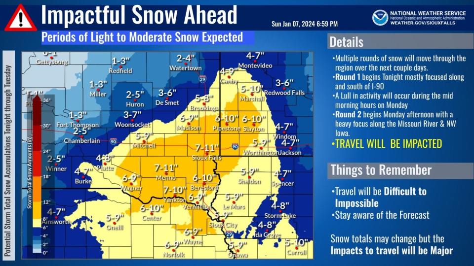
3:45 p.m. Sunday: The winter weather watch for Sioux Falls has been upgraded to a winter storm warning, according to the National Weather Service of Sioux Falls.
The warning extends from midnight Sunday to 6 a.m. Tuesday, the alert states. Heavy snow is expected, with accumulations of anywhere from 6 to 10 inches for Lincoln and Minnehaha counties.
Travel will be impacted. If you must travel, the NWS advises drivers to keep flashlights, food and water in vehicles in case of an emergency.
Winter Weather headlines across the area have been updated this Sunday afternoon.
Winter Storm Warnings and Winter Weather Advisories now cover the majority of the region through Tuesday morning.
Winter Storm Watches have expired.
Please check road conditions before traveling! pic.twitter.com/G4x2tzvhjd— NWS Sioux Falls (@NWSSiouxFalls) January 7, 2024
Earlier story: Southeastern South Dakota, including Sioux Falls, is now under a winter storm watch, according to the National Weather Service.
The watch, which runs from Sunday evening through late Monday night, comes as a winter system is expected to bring anywhere from 5 to 9 inches of accumulating snowfall to the area, the alert reads.
The NWS predicted as of Sunday morning there is a 61% the area could see more than 6 inches of snow by the time the storm passed through.
The storm could affect travel, with slippery roads and hazardous conditions expected for morning and evening commutes, the NWS of Sioux Falls states.
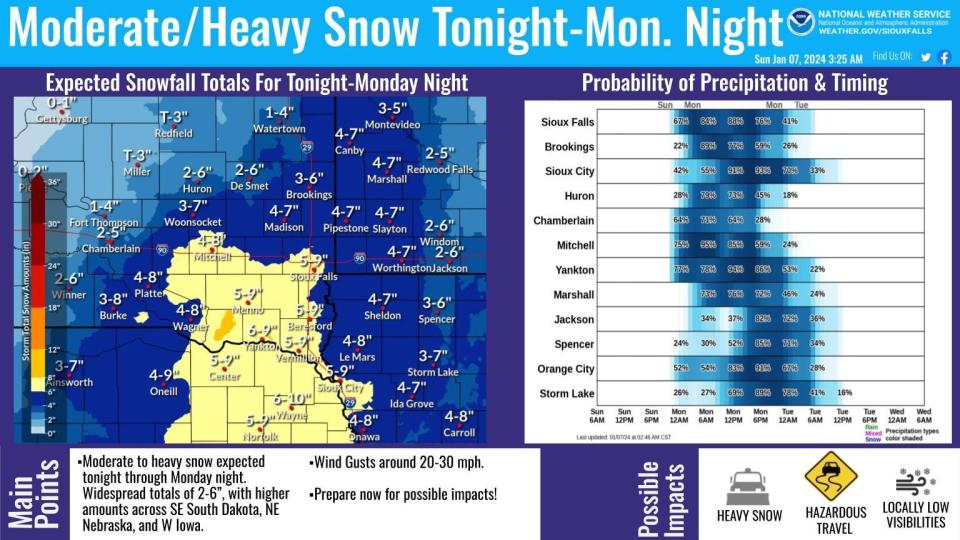
When will the storm hit?
The heaviest snowfall is expected to hit Sioux Falls at about 6 a.m. Monday and will continue through midnight and into the early hours Tuesday, the NWS of Sioux Falls stated in a weather briefing Saturday evening.
Here's an estimate of how much snow will fall every 6 hours starting late Sunday night, and ending Tuesday morning.
The darker blue shades indicate heavier snowfall amounts.
Totals across the entire area by the time the storm moves out will vary widely from 2 to 10 inches. pic.twitter.com/8sRgJKoplh— NWS Sioux Falls (@NWSSiouxFalls) January 7, 2024
How can I stay informed?
Keep refreshing argusleader.com for the latest, or visit the National Weather Service in Sioux Falls website.
Also, check www.sd511.org for road condition updates.
What will conditions look like the rest of the week?
After the storm, temperatures are expected to plummet during the evenings throughout the week, with a few nights reaching single-digits or below-zero Temps. Here's a closer look, according to the NWS of Sioux Falls.
Sunday: Partly sunny, with a high near 26. Calm wind becoming southeast around 5 mph in the afternoon.
Sunday night: Snow likely, mainly after 3am. Cloudy, with a low around 21. East southeast wind 5 to 15 mph, with gusts as high as 20 mph. Chance of precipitation is 60%. New snow accumulation of around 2 inches.
Monday: Snow. High near 32. East wind 10 to 15 mph, with gusts as high as 20 mph. Chance of precipitation is 90%. New snow accumulation of around 2 inches.
Monday night: Snow likely, mainly before midnight. Mostly cloudy, with a low around 15. North wind 10 to 15 mph, with gusts as high as 25 mph. Chance of precipitation is 70%. New snow accumulation of less than one inch possible.
Tuesday: Partly sunny, with a high near 21. Blustery, with a north wind 10 to 20 mph, with gusts as high as 25 mph.
Tuesday night: Mostly cloudy, with a low around 9.
Wednesday: A 30% chance of snow. Mostly cloudy, with a high near 27.
Wednesday night: Mostly cloudy, with a low around 1. Blustery.
Thursday: Mostly sunny, with a high near 7.
Thursday night: Mostly cloudy, with a low around -7.
This article originally appeared on Sioux Falls Argus Leader: Sioux Falls school closures, snow totals: Dangerous wind chills ahead

