Winter storm to drop snow, rain, sleet on New York's Hudson Valley
The Hudson Valley is experiencing the tail end of an extreme cold spell, but the bitter winter temperatures are likely to intensify the effects of a winter storm making its way north toward the area.
Snow is expected to blanket the region between Sunday night and early Monday, with a wide range of accumulation, from as little as inch in southern Westchester County to almost a foot in Sullivan.
Snow is moving up the East Coast and will likely hit New York City between 7 and 8 p.m., said John Gresiak, a senior meteorologist at AccuWeather. The storm is expected to move up through the Hudson Valley between then and midnight, he said.
Most areas, Gresiak said, should expect between one and three inches of snow, which will likely be wiped out by sleet and rain by morning. Areas farther north should expect slightly colder temperatures and slightly more snow than areas closer to New York City, Gresiak said, adding that driving conditions might be worse in those areas.
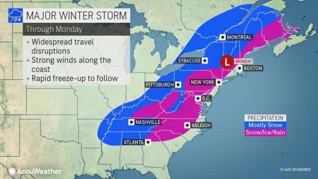
Snow: How much will fall in New York on Sunday and Monday?
Education: New York schools can skip COVID contact tracing
The National Weather Service predicts about an inch in Westchester and Rockland counties, three inches in Putnam and Dutchess, four in Orange, five in Ulster and anywhere from five to 11 inches in Sullivan.
A winter weather advisory will be in effect from 5 p.m. Sunday until 5 p.m. Monday in Sullivan County; 6 p.m. until 6 a.m. in Orange and Putnam; and 10 p.m. until noon in Dutchess and Ulster.
Gresiak said even though temperatures are climbing and likely to reach the mid- to upper-30s by early Monday morning, pavement and other surfaces will likely still be frozen as snow, sleet and freezing rain move into the region Sunday evening.
This could negatively impact driving conditions late Sunday night and well into Monday morning.
“It's really, really cold out there right now, so the paved surfaces and such are going to be very cold. Even when the temperature goes up above 32 degrees later tonight and tomorrow morning there may still be ice collecting on some surfaces," Gresiak said Sunday afternoon. "That's something you've really got to watch out for during the morning commute tomorrow."
Temperatures are likely to dip below freezing again on Monday night and early Tuesday morning, Gresiak added, which could cause surfaces still wet from the upcoming storm to freeze over.
"If you end up with like some slush, standing water or anything else tomorrow afternoon or evening, you might want to get rid of that as quickly as you can because later tomorrow night and on into Tuesday morning it'll probably freeze back up and then it'll be really hard to get rid of," he said.
"Tomorrow morning's commute is going to be rough for those who have to actually commute," Gresiak said before offering a bit of optimism. "But after that things kind of ease up a bit for the next couple of days and it is actually going to get a little milder for a day or two midweek."
This article originally appeared on Times Herald-Record: Snow, winter weather on track to hit Hudson Valley in New York
