How will the winter storm forecast for this weekend affect the Tri-State area?
The Tri-State area is likely to escape the brunt of the winter storm heading to the East Coast later this week, according to the National Weather Service.
While there remains some uncertainty in the storm's track, the confidence in the forecast for the Tri-State area to escape big snow accumulations is higher than what's predicted along the coast, said Jeremy Geiger, a meteorologist for the Baltimore/Washington forecast office.
Generally, the forecast for Friday calls for 1 to 2 inches of snow in the Hagerstown area and possibly 1 to 3 inches for West Virginia's Eastern Panhandle, Geiger said. It's a light to moderate snow.
Franklin and Fulton counties in Pennsylvania could see a half inch to an inch of snow Friday, said meteorologist Aaron Tyburski with the State College, Pa., forecast office.
Online education: Washington County Public Schools might be able to replace snow days with virtual learning
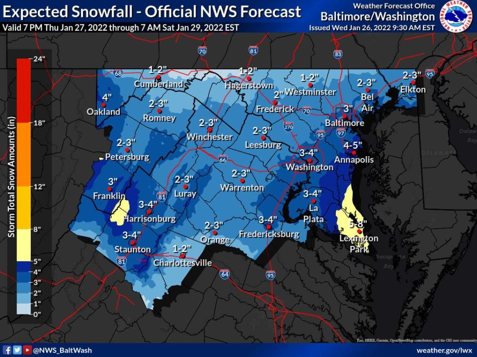
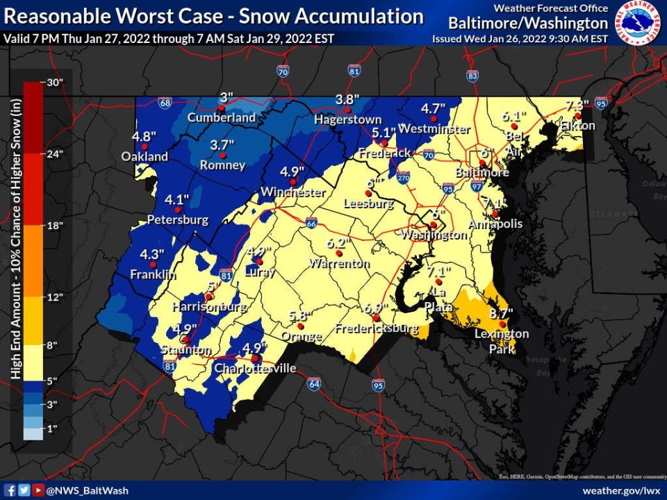
Graphics the Baltimore/Washington forecast office posted around 9:30 a.m. Wednesday show an official forecast for 1 to 2 inches of snow in the Hagerstown area, while a graphic for the "reasonable worst case" shows 3.8 inches for the Hub City through Saturday morning.
Meanwhile, the weather service has issued a hazardous weather statement for the Lower Eastern Shore due to the potential for "significant snow accumulation" Friday night into Saturday, according to the website for the Wakefield, Va., forecast office.
The storm, generally, will have pulled out of the local area by Saturday, though there is chance for snow to continue into Saturday morning, Geiger said.
Geiger and Tyburski said it's always good to be cautious driving, even with a small amount of snow, due to the potential for slippery roads. Temperatures are expected to be around freezing — maybe slightly above — as the snow falls Friday. That could create the potential for slippery roads around sunrise Friday, Tyburski said.
Of more immediate interest are the temperatures, which could reach the upper 20s Wednesday, with wind chills in the teens, Geiger said. The lows in Washington County and the Eastern Panhandle are expected to be in the single digits overnight.
It will warm a little Thursday to around 31, 32 degrees, he said.
This article originally appeared on The Herald-Mail: How snow storm will affect Washington County, Tri-State area

