Winter storm warning will remain in effect for Central Indiana through Saturday morning
This article is available for free as a public service. If you can, please subscribe to IndyStar to support our work.
A winter storm warning that went into effect Thursday afternoon will remain in place for Central Indiana, including Indianapolis, until 7 a.m. Saturday.
Although snowfall has come to an end, dangerous cold and gusty wind resulting in blowing and drifting snow have not let up. The winter storm warning states residents should plan on slippery road conditions, with blowing snow reducing visibility.
Dangerously cold wind chills of minus 25 to minus 35 degrees will be common. Wind gusts as high as 45 mph are expected Friday night.
Indiana winter storm warning:Find warming center hours and locations during winter storm in central Indiana
Hamilton, Hendricks, Morgan, Johnson, Shelby and Hancock counties were among those with a heightened "watch" travel status Friday evening, according to the Indiana Department of Homeland Security. That means only essential travel is recommended. Marion and Boone counties had a travel advisory, the lowest level, which means drivers should use caution.
5:05 p.m.: NWS extends winter storm warning through Saturday
The winter storm warning affecting most of Central and Northern Indiana has been extended through 7 a.m. Saturday, according to the National Weather Service. Dangerously cold wind chills, blowing snow and slippery road conditions are expected to continue throughout the night.
LATE AFTERNOON UPDATE:
We are extending the Winter Storm Warning for all of central Indiana thru 7 am Sat. Conditions remain dangerous w/ high winds causing blowing & drifting snow. Wind chills as low as -30 to -35 expected again tonight. Light snow at times as well. #INwx #indy— NWS Indianapolis (@NWSIndianapolis) December 23, 2022
2:30 p.m.: How much snow did Indiana get?
Most of Indiana saw somewhere between 1-3 inches of snow in the last 24 hours, according to the National Weather Service, although the high winds have made it nearly impossible to measure the total snowfall.
The following snowfall recordings were gathered from the Community Collaborative Rain, Hail & Snow Network, which is a network of volunteers that observes and records their local weather events in a centralized database.
Indianapolis: 1.3 inches
Greenwood: 0.18 inches
Carmel: 0.20 inches
Fishers: 0.20 inches
Zionsville: 0.26 inches
Bloomington: 0.21 inches
Areas further north saw more snow, with users in La Porte reporting nearly 9 inches total. Users in South Bend reported 4.5 inches fell in their area.
Let it snowHow much snow did Indiana get? Here are snowfall totals from across the state
2:00 p.m.: Firefighters face extra challenges in cold temperatures
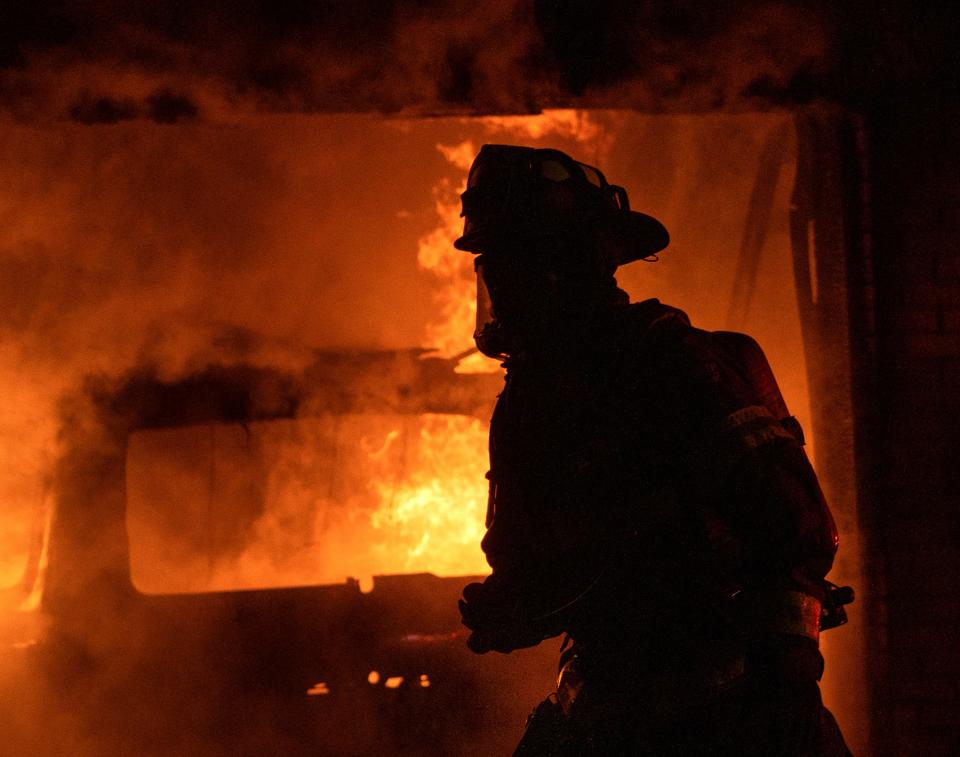
Pike Township firefighters faced extra challenges due to the extreme cold weather while fighting a house fire Thursday night.
As they battled the fire on Indianapolis’ northwest side around 9:30 p.m., firefighters encountered a frozen fire hydrant, said Jonathan Kempler, division chief and fire marshal with Pike Township Fire Department.
“We encounter frozen hydrants every winter even though hydrants in the Midwest are designed to be dry until they are activated by a firefighter,” Kempler said. “Underground seals can start to leak, and the fire hydrant can start to fill up with water, causing it to freeze when the temperature falls.”
Some firefighters on scene in the 9200 block of Clemson Street also faced issues with their air supply tanks due to the cold.
“Some of the firefighters had their air supplies interrupted due to ice and cold weather and had to switch out some of their equipment,” Kempler said.
“Once we get on scene, we are working out in the elements, so we have to be monitoring for hypothermia and weather-related medical problems,” Kempler said. “We are working with water, which can turn to ice quickly on our vehicles, equipment and protective gear.”

Ice on protective gear and other equipment adds extra weight, which causes extra energy to be exerted when fighting a fire, Kempler said.
No injuries were reported in the fire, according to the department.
"Even though the hydrants are regularly serviced, we have thousands of them in Marion County, so it helps if we have an extra set of eyes to help us out,” Kempler said of how residents can help. “Reporting any leaking fire hydrants throughout the year always helps us out.”
Cold weather and poor road conditions also add to the challenge of responding to calls in the winter as fire crews navigate other motorists on the road, Kempler said.
He also encouraged residents to heed travel restrictions and stay off the roads, when possible, to assist the fire department during winter storms.
12:41 p.m.: NWS points to rare, below-freezing conditions
The last time #Indianapolis failed to reach 0 degrees for a high temp was back on 1/18/1994 when the high was -4F! Current temperature as of 12PM is -5F. To show how rare this is, since 1880, there have only been 16 days where the high did not reach 0 degrees! #inwx
— NWS Indianapolis (@NWSIndianapolis) December 23, 2022
11:48 a.m.: Solid waste operations cancelled in Indianapolis
For the safety of our crews, solid waste operations will not be conducted today. Residents who receive trash collection on Fridays should expect to have double collection on Friday, December 30. https://t.co/o1mHBGboAw
— Indy Department of Public Works (@IndyDPW) December 23, 2022
11:41 a.m.: Snowplows continue to clear the roads in Indy
More than 100 Snow Force crew members and 76 snow plows are still out clearing and treating roadways throughout Indianapolis. Indy DPW continues to urge residents to avoid unnecessary travel.
You can stay up to date on which streets have been plowed at https://t.co/NWiTV8Om4I pic.twitter.com/lbjKBolY6w— Indy Snow Force (@IndySnowForce) December 23, 2022
11:15 a.m.: ISP asks drivers to slow down
Trooper Hank Kalina is the Third Trooper in our District to be struck while investigating a crash in the past 15 hours.
He was transported to an area hospital with non-life threatening injuries
Please SLOW DOWN
4-wheel drive doesn’t help you stop on a slick road pic.twitter.com/lZVPxPwNAK— Sgt. John Perrine (@ISPIndianapolis) December 23, 2022
10:50 a.m.: ISP updates on vehicle crashes
10:25 a.m.: IndyGo resumes regular operating routes
Modified service: Snow detours. At this moment, all routes are operating on the regular routing. All snow detours have been canceled.
— IndyGo Rider Alerts (@IndyGoAlerts) December 23, 2022
10:10 a.m.: Flights cancelled at Indianapolis International Airport
Thirty one flights have been delayed and 110 flights have been cancelled at Indianapolis International Airport on Friday, according to the national flight data aggregator FlightAware. The cancellations were close to evenly split between flights into and out of Indianapolis.
Five flights scheduled for Saturday have already been cancelled at the airport, according to FlightAware.
9:50 a.m.: How much snow did Indianapolis get?
At the National Weather Service office on West Hanna Avenue, meteorologists measured about 1.3 inches of snow from the storm, said meteorologist Matthew Eckhoff.
The snow was difficult to measure due to the high winds, so the meteorologists had to take more of an educated guess than an exact measurement, he said.
The snow total in Indianapolis was lower than predicted in central Indiana as heavier snows shifted further east than anticipated, according to NWS.
9:30 a.m.: Cold temperatures continue, Indy Parks shares info on warming centers
Temperatures continue to be brutally cold. Warming centers are open for those who need them. https://t.co/AGA97DKIdG pic.twitter.com/Gd9qQysdOr
— IMPD (@IMPDnews) December 23, 2022
9:20 a.m.: Tips and tricks for dog owners as temperatures remain below zero
Read here:How to get your dog to potty in the snow and cold weather
8:50 a.m.: FedEx reports national service disruption due to storm in Indy
FedEx Express experienced substantial disruptions at its Indianapolis and Memphis hubs Thursday night due to the severe winter weather, according to an update on its website.
Potential delays are possible for package deliveries across the U.S. with delivery commitment dates of Friday and Saturday, according to the company.
Customers can check the service alerts page for updates and track shipments on fedex.com.
UPS service has also been impacted by the storm, according to the company's website.
"Significant weather events across several regions of the U.S. are impacting the UPS Air and Ground network, including UPS hubs in Louisville, Kentucky and Rockford, Illinois," a service alert from UPS reads. "As a result, some delivery and pickup services in these areas will be affected."
The company did not provide specific information when asked if services would be impacted in Indiana and Indianapolis.
"Due to the storm, our situation is fluid and contingency plans are in progress," the company stated. "Safely delivering on our commitments is UPS’s most important priority. Our drivers are trained to safely make deliveries, and if we cannot safely deliver to an area, we will resume service as soon as conditions permit."
Consumers can use UPS My Choice to track their packages, leave special delivery instructions for their driver, and redirect their packages to a nearby UPS Access Point location, according to the company.
7:00 a.m.: Less than 1,000 AES customers remain without power
7am: 713 customers w/out power. We're all-hands on deck and have been staffing up since we activated our storm plan Monday. If you're driving today and see our utility trucks, please slow down and give them room to work. Safety is our #1 core value. (photo @SamJohnsonNews @WTHR) pic.twitter.com/wR9of98Zjs
— AES Indiana (@AESIndiana) December 23, 2022
The Duke Energy outage map shows about 1,600 of their customers throughout Indiana are without power.
6:30 a.m.: NWS warns of frostbite from temperatures below zero
With wind chills around -40° frostbite can occur in a matter of minutes. Know the symptoms before you head out and make sure you are well bundled up if you do. #INwx pic.twitter.com/c7oi0fapjv
— NWS Indianapolis (@NWSIndianapolis) December 23, 2022
6:15 a.m.: 2,500 AES customers without power
6am update: Freezing rain and high winds have knocked down trees, limbs and power line across our service territory. Crews have been working around-the-clock as quickly and safely as possible to restore your power. 2,576 customers currently w/out power (down from 5,000+ at 4am)
— AES Indiana (@AESIndiana) December 23, 2022
5:50 a.m.: Wind gusts, bitter cold continues into Friday
A Winter Storm Warning will remain in place through the day with the focus being the extremely cold wind chills and strong winds. Snow has come to an end, but blowing snow will remain a hazard through the day. #INwx pic.twitter.com/r0F8n841TS
— NWS Indianapolis (@NWSIndianapolis) December 23, 2022
Winds will frequently gust 40-45 mph today with occasional stronger gusts possible. These strong winds will cause snow to blow around and cause power outages. Avoid outdoor travel if possible! #INwx pic.twitter.com/Cga1UbEACX
— NWS Indianapolis (@NWSIndianapolis) December 23, 2022
10:34 p.m. Thursday: The temps in Indy, Muncie, Lafayette, Bloomington and Terre Haute
Time for a temperature check at 1030 pm...still dropping like a rock.
Indy: 2°
Muncie: 9°
Lafayette: -1°
Bloomington: 4°
Terre Haute: 0°
Wind chills now below -20° in spots. Stay warm and safe folks. #INwx #indy— NWS Indianapolis (@NWSIndianapolis) December 23, 2022
12:40 a.m.: State troopers respond to crashes
In the past 9 hours, Troopers in the Indianapolis District have responded to:
41 crashes (7 with injuries)
11 slide offs
23 motorist assists (disabled vehicles)
Roads are hazardous and the temperature is extremely dangerous
Please only go out if you absolutely have to— Sgt. John Perrine (@ISPIndianapolis) December 23, 2022
10:20 p.m.: Officials urge drivers to stay off roads
It is dangerously cold in Indianapolis and all of Marion County. Roads are frozen over in many places and travel is very difficult and potentially dangerous. Travel condition is ⚠️ YELLOW, use caution when traveling. pic.twitter.com/vlH7wSqKzj
— Marion County Emergency Management - Indianapolis (@MarionCo_EM) December 23, 2022
9:30 p.m.: Large outage hits 3k customers on southeast side
AES Indiana is experiencing a large outage on the southeast side of Indianapolis. There are 3,089 customers without power. AES Indiana crews are responding to this outage.
9:25PM: AES Indiana is experiencing a large outage on the southeast side of Indianapolis. There are 3,089 customers without power. AES Indiana crews are responding to this outage.
— AES Indiana (@AESIndiana) December 23, 2022
7:35 p.m.: Power outage on far east side affects over 800 people
Power outages on the far east side of Indianapolis are affecting over 800 people near the area between 42nd and 38th streets. AES Indiana is estimating that power will be restored around 10 p.m.
View where more outages are in Indianapolis at https://myaccount.aesindiana.com/outages/outagemap.
7:15 p.m.: Jackknifed semi blocks all northbound I-465 lanes
A jackknifed semi has blocked all lanes of traffic on northbound Interstate 465 between East 56th and East 71st streets near Lawrence, according to the Indiana Department of Transportation. Traffic will be delayed for an estimated hour and half in that area.
7:05 p.m.: Around a dozen departing flights canceled Thursday night
Around a dozen departing flights from the Indianapolis International Airport are now canceled due to the weather Thursday night. Among all flights going in and out of Indianapolis, there have been a total of 32 canceled flights.
Now counting about a dozen cancelled departures today (that's about 10% of Indy's departing flights) on https://t.co/QibFeZaDRo. Based on stats from FlightAware, tomorrow is looking similar so far. https://t.co/ldXwEBSENX
— Kayla Dwyer (@kayla_dwyer17) December 22, 2022
6:35 p.m.: Semi crash blocks three left lanes on northbound I-465
A crash on northbound I-465 between I-70 and the Sam Jones Expressway involving a semi has blocked the three left lanes. Delays in that area are expected for the next hour, according to the Indiana Department of Transportation.
A Target Tractor Trailer hit the median at 465 Northbound at the Same Jones Expwy. @WISH_TV pic.twitter.com/mYgLk09lYO
— Adam Pinsker (@AdamPinsker) December 22, 2022
5:34 p.m.: Power outage on far east side affects 960 customers
AES Indiana reports that around 960 customers are without power on the far east side of Indianapolis, between 30th and 38th streets, due to a fallen wire. Crews are working now to restore the power.
View where more outages are in Indianapolis at https://myaccount.aesindiana.com/outages/outagemap.
4:50 p.m.: Crash involving semi on I-70 stops all lanes of traffic
All lanes are blocked on I-70 after a crash involving a semi-trailer spilled its load between Mount Comfort Road and 400 west, according to the Indiana Department of Transportation.
Expect to see delays and slow traffic in this area for the next hour and a half.
I-70 EB: Crash involving a semi trailer because of a spilled load between Mount Comfort Rd and 400 W (MM 97, 3m E of Indianapolis city (balance)). For the next hour and a half. All lanes blocked. https://t.co/JlUzazdHkp
— INDOT TrafficWise (@TrafficWise) December 22, 2022
4:04 p.m.: Indy Snow Force Viewer app is live with road-clearing updates
The Indy Snow Force Viewer map is now live with updates on where streets are being plowed and salted in the Indianapolis area. Residents can check the app at https://maps.indy.gov/IndySnowForceViewer for regular updates on where roads have been treated recently.
The Indy Snow Force Viewer mapping tool is now activated during this winter weather event. Residents can use the tool to monitor where crews have recently plowed snow or treated roadways: https://t.co/wgvWYidSmY pic.twitter.com/TDsxQvdzgV
— AES Indiana (@AESIndiana) December 22, 2022
3:30 p.m.: Friday trash services in Carmel suspended
Republic Services will suspend trash and recycling services for Friday, according to the City of Carmel. Trash and recycling will instead be picked up on Monday.
Moving into next week, residents should plan to set out carts on their normal service day with the understanding there may be a one-day delay while Republic Services catches up on each route, according to the city.
Winter storm in Indiana:When will my road be plowed in Indianapolis?
2:34 p.m.: Indianapolis Airport reporting some flight delays, cancellations
We're seeing some delays and cancellations from airlines as the winter storm moves across the Midwest. Please check with your airline for any disruption in your flight schedule before arriving at the airport. #INwx
— Indianapolis International Airport (IND) (@INDairport) December 22, 2022
2:15 p.m.: Indianapolis Public Schools cancels athletic events Thursday night and Friday
Just in: All @IPSSchools athletic events, including games and practices, have been canceled for tonight and Friday due to the bad inclement weather.
— Caroline Beck (@CarolineB_Indy) December 22, 2022
1:40 p.m.: Indianapolis Public Library locations closing
Due to the predicted severe weather, all Indianapolis Public Library locations will close at 3pm today and remain closed tomorrow, December 23. Please be safe and take advantage of all of our online services at https://t.co/rYvmvz3b3n! pic.twitter.com/ndPw2EbNT2
— Indianapolis Public Library (@indylibrary) December 22, 2022
1:10 p.m.: Travel advisories issued in counties near Indianapolis
Hendricks, Shelby and Hancock counties have issued travel advisories, while Hamilton County has issued a travel watch.
What does this mean:
Advisory: The lowest level of local travel advisory, means that routine travel or activities may be restricted in areas because of a hazardous situation, and individuals should use caution or avoid those areas.
Watch: Means that conditions are threatening to the safety of the public. During a watch local travel advisory, only essential travel, such as to and from work or in emergency situations, is recommended, and emergency action plans should be implemented by businesses, schools, government agencies, and other organizations.
Warning: The highest level of local travel advisory, means that travel may be restricted to emergency management workers only. During a warning local travel advisory, individuals are directed to:
Refrain from all travel
Comply with necessary emergency measures
Cooperate with public officials and disaster services forces in executing emergency operations plans
Obey and comply with the lawful directions of properly identified officers.
1 p.m.: IMPD reminds residents to bring pets inside as cold temperatures approach
Pet owners: please be weather aware over the next few days and bring your furry friends INSIDE !!! 🐶🐱 https://t.co/pTXgYiNhMn
— IMPD (@IMPDnews) December 22, 2022
12:30 p.m: Carmel closing Christkindlmarkt due to winter storm
The Carmel Christkindlmarkt will close Thursday afternoon and all day Friday due to the forecasted winter storm that is expected to bring snow, high wind gusts and below-zero wind chills to Central Indiana in the coming days.
In a tweet Wednesday afternoon, the Christkindlmarkt account stated the decision to close the Christmas market Friday was made "after carefully reviewing the upcoming weather with our staff and the City of Carmel."
A tweet Thursday afternoon stated the market would close at 3:30 p.m. today.
The Christkindlmarkt is still open Christmas Eve from 11 a.m. to 4 p.m. and closed on Christmas Day.
Due to the incoming weather, we have made the decision to close the Market today, Dec. 22, at 3:30 pm. We will also be closed tomorrow, Dec. 23, due to the weather, as well as on Dec. 25 as previously scheduled. We will update if any additional closures are determined. pic.twitter.com/9k7ZMjtMzv
— CarmelChristkindl (@CarmelChristkin) December 22, 2022
12:20 p.m.: Indy DPW crews working extended shifts to keep roadways clear
100 Indy DPW crew members are working extended shifts throughout this holiday weekend to keep Indianapolis roadways clear and Indianapolis residents safe amid rain, freezing temperatures, and winter weather.
Here’s what you can do to stay safe and help Indy Snow Force work: pic.twitter.com/Gj105yt2jb— Indy Snow Force (@IndySnowForce) December 22, 2022
The city's department of public works is asking residents to:
Avoid unnecessary travel tonight as roads are being pre-treated following rain to prevent freezing.
Look for flashing amber lights which indicate plow trucks on the road.
Stay at least three car lengths away from plows to avoid snow clouds and flying salt.
Indianapolis residents can view Snow Force progress via https://maps.indy.gov/IndySnowForceViewer/… to see which streets have been plowed and how recently.
11:15 a.m.: Frostbite a concern as winter storm approaches
The Richard M. Fairbanks Burn Center at Eskenazi Health is warning about the danger of frostbite. Frostbite often mirrors burn injuries and can result in life-long skin damage.
"Staying inside is the best thing we can all do during times like these,” said Brett Hartman, D. O., burn center medical director.
If you must go outside, everyone should always wear a hat, a scarf or knit mask to cover the face and mouth, sleeves that are snug at the wrist, mittens (they are warmer than gloves), water-resistant coat and boots, and several layers of loose-fitting clothing.
Frostbite causes skin to become cold and red, then numb, hard and pale. Additional symptoms include a tingling sensation, followed by numbness on the affected area. Frostbite will make skin hard, pale and cold, and feeling may be lost in those areas.
11 a.m.: Call 2-1-1 to find a warming shelter
Warming centers will be open across the state for those in need of a safe and warm place to stay. Indiana 211 is a resource for updated locations and hours of warmings centers as many of the locations people may seek shelter could be closed due to the holidays.
10:50 a.m.: NWS warns, 'don't fixate on snow'
With a winter storm of this magnitude, don't fixate on snow totals and ignore the other hazards. With wind gusts up to 60mph, wind chills down to -35, and dangerous travel anticipated, this event is shaping up to be severe regardless of accumulations. #INwx pic.twitter.com/6SuEiXXNmO
— NWS Indianapolis (@NWSIndianapolis) December 22, 2022
9:55 a.m.: Handful of Indianapolis International Airport flight cancellations reported, how to check
I'm only seeing a small handful of cancelled flights so far out of Indy -- 3 of the 5 cancelled departures are to Chicago.
If your flight is cancelled or delayed, here's a dashboard of all the major airlines and what they will and won't do for you: https://t.co/8VGgcHGVaL— Kayla Dwyer (@kayla_dwyer17) December 22, 2022
9:35 a.m.: NWS says storm will bring high winds, extreme wind chill
A strong cold front associated with a strengthening storm will plow into Indiana this afternoon. High winds, extreme wind chill, blowing snow, and periods of heavy snow are expected. Plan travel accordingly. #INwx pic.twitter.com/AWmVVtMTli
— NWS Indianapolis (@NWSIndianapolis) December 22, 2022
This article originally appeared on Indianapolis Star: Indiana winter storm 2022: Updates from Indianapolis

