A winter storm Saturday could bring over 4 inches of snow to Manitowoc, Sheboygan and areas west of Milwaukee
Our winter storm coverage has updated. View the latest information here.
The first day of spring was earlier this week, but winter isn't ready to leave yet. Another snowstorm is forecast for Friday into Saturday in eastern Wisconsin, especially in Manitowoc, Sheboygan, and communities in between Milwaukee and Madison.
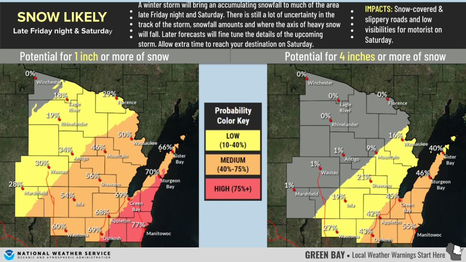
Many areas have a chance of seeing at least an inch and possibly over four inches of snowfall starting Friday night and continuing into Saturday, according to the National Weather Service.
"We're going to get something," said Aidan Kuroski, a meteorologist with the National Weather Service in Milwaukee / Sullivan. "We're just not sure yet how much it will be."
As of Thursday morning, there was still a lot of uncertainty over where the storm will track and how much snow will fall. Here's what we know so far.
How much snowfall could we see?
That depends on which of two tracks the storm could take, the NWS said.
One possibility is the snow falling in southeastern Wisconsin. That would also mean areas further west wouldn't see much snow at all due to a sharp cutoff.
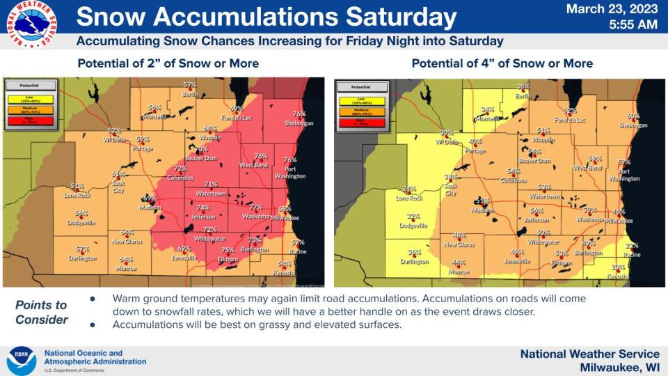
However, the storm could still track more to the west, bringing more widespread snowfall across southwestern and central Wisconsin, while cities like Racine and Kenosha have a stronger likelihood of seeing rain or wintry mixes.
As of Thursday morning, the strongest likelihood is that over two inches will fall in Sheboygan, Port Washington, and communities in between Milwaukee and Madison like Elkhorn, Columbus, West Bend and Waukesha.
Further north, the strongest probability for snowfall accumulation as of Thursday was in Manitowoc and Door Counties, though Appleton, Oshkosh, Fond du Lac and Green Bay are likely to see at least an inch.
As of Thursday morning, "it's difficult to say which track" the storm will follow, Kuroski said. However, he said the NWS could have more updates as early as Thursday afternoon.
When will the snow fall?
While more exact times are still a day or two away, it seems likely the snow will fall starting late Friday night and continuing into Saturday afternoon, the NWS said.
The heaviest snow is currently expected before noon on Saturday, starting at midnight and continuing into the morning hours.
Will the weather impact travel?
Warm ground temperatures will most likely melt much of the snow as soon as it hits the asphalt, the NWS said. Whether or not this impacts travel ultimately depends on when the snow will fall, Kuroski said.
"It's really about how much we get from 12 to 6 (a.m.)," he said. During that time, the snow is more likely to stick to the roads, while any snowfall later is more likely to melt as soon as it hits the ground.
Milwaukee weather radar
Rebecca Loroff is a breaking and trending news reporter for USA TODAY NETWORK-Wisconsin. Contact her at rloroff@gannett.com.
This article originally appeared on Milwaukee Journal Sentinel: March winter storm could bring over 4 inches snow to eastern Wisconsin

