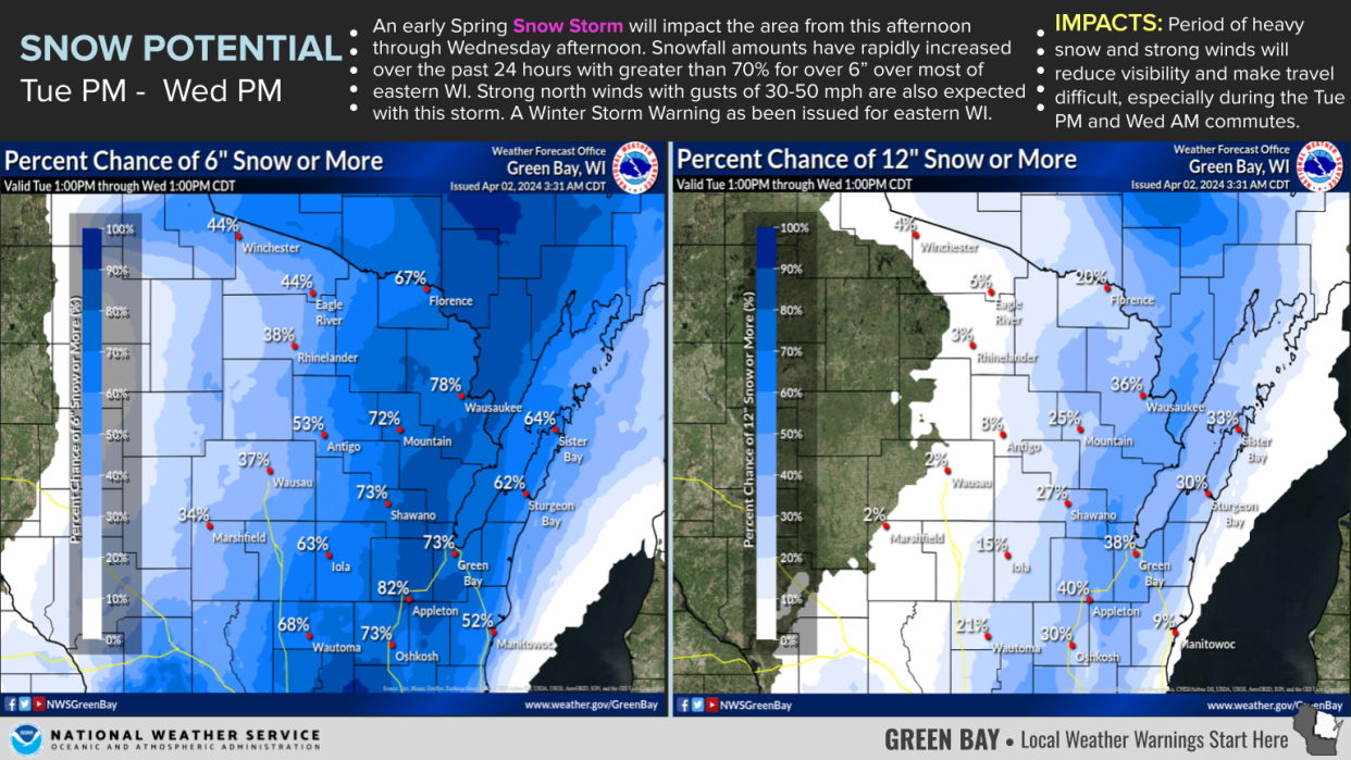
Winter storm warning issued for northeast Wisconsin, Fox Valley can expect 8-12 inches of snow
With the start of April, the Fox Valley may get a foot of snow.
The National Weather Service Green Bay issued a winter storm warning for most of northeast Wisconsin, beginning at 1 p.m. Tuesday and lasting until 1 p.m. Wednesday.
The Fox Valley can expect 8 to 12 inches of snow.
It's an increase from the 4 to 8 inches previously predicted. Roy Eckberg, a meteorologist with the National Weather Service Green Bay, said some areas may see even more than a foot of snow.
"Not quite sure where that's going to be at this point, but there's potential for higher numbers somewhere in the Fox Valley/lakeshore region," Eckberg said.
Eckberg said the heaviest snowfall will come Tuesday afternoon into the night. Most of the heavy snowfall should wrap up Wednesday morning, but snow may continue as long as Thursday morning.
Tuesday is election day, so anyone driving to the polls should be aware of snowy roads.
Will there be any hazardous conditions?.
Wednesday is anticipated to be extremely windy, Eckberg said, with gusts reaching 45 mph.
"A combination of the heavy, wet snow (and) winds could bring some sporadic damage to trees and powerlines, so there could be some power outages," he said.
As blowing snow will decrease visibility and cause slippery roads, the National Weather Service Green Bay is advising people to delay travel if possible. Those that must drive should be very cautious and consider bringing a winter storm kit, with items like blankets, extra clothing, tire chains, booster cables, a flashlight, shovel, water and a first-aid kit.
Because the snow will be heavy and wet, shoveling and clearing roads may be more of a challenge than normal, Eckberg said.
How long will the snow stay on the ground?
Temperatures are not expected to remain below freezing for long.
"We're gonna be in the 40s — we'll be in the upper 30s tomorrow, low 40s on Thursday, and by Friday, we're in the mid 40s. So a majority of the snow will melt by the weekend," Eckberg said.
Are April snowstorms common?
Snow in April is not uncommon in Wisconsin. But the upcoming storm is expected to be more powerful than most springtime flurries.
"To get a 4 to 8 inch snowfall in April is fairly common every couple years. But to get ... over 9, 10 inches is pretty uncommon," Eckberg said.
However, a large snowstorm hit northeastern Wisconsin in April of 2018. That storm, over the course of about three and a half days, brought a total of over 21 inches of snow to Appleton and over 24 inches to Green Bay.
The upcoming snow will be the largest April snowstorm since then, Eckberg said.
Contact Kelli Arseneau at 920-213-3721 or karseneau@gannett.com. Follow her on X, formerly Twitter, at @ArseneauKelli.
This article originally appeared on Appleton Post-Crescent: Winter storm warning issued for northeast Wisconsin, Fox Valley can expect 8-12 inches of snow

