Winter storm warnings issued with the potential for snow squalls, heavy snow for northern Utah
SALT LAKE CITY (ABC4) — An active winter weather pattern is getting a grip on parts of Utah.
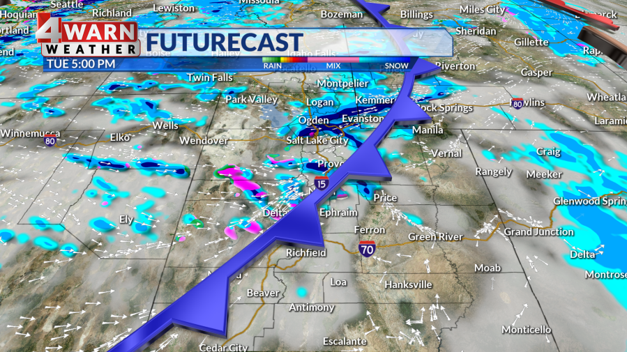
Waves of moderate to heavy snow are expected for northern Utah as a powerful system is on track to traverse the Beehive State Tuesday, bringing the potential for blowing snow, freezing temperatures and healthy accumulations for valleys and the high country.
UTAH WEATHER EXPLAINERS Over 60% of Utah in ‘Code Blue’ as winter storms approach
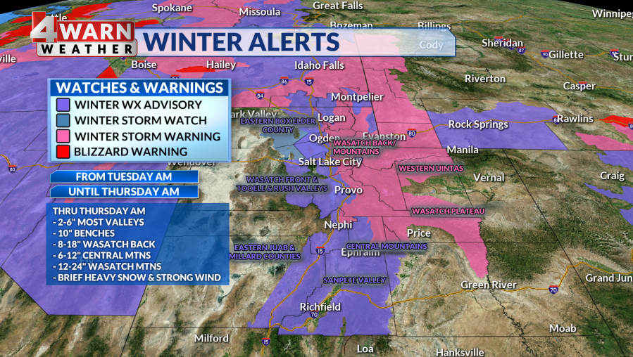
Several waves of precipitation are expected Tuesday night through Thursday and as a result the National Weather Service has issued winter storm warnings for the Wasatch Mountains, Wasatch Back, Wasatch Plateau and the Western Uintas. The warnings are set to go into effect 8 a.m. Tuesday and last through early Thursday morning.
Between 15 to 30 inches of snow could stack up in the northern mountains, with the potential for 3 feet of fresh powder in the Cottonwoods. Travel along mountain routes is expected to be treacherous at times, with periods of heavy snow and gusty winds impacting visibility with blowing snow and high snow drifts.
“It’s going to stay very active with periods of snowfall over the next several days. Heavy mountain snow will lead to a rise in avalanche danger, and accumulating valley snow with cause for several tricky commutes including Tuesday and Wednesday evenings for parts of the state,” ABC4 Chief Meteorologist Alana Brophy said.
With valley snow expected and impacts to our roads ahead, the National Weather Service has also issued several winter weather advisories for parts of northern and central Utah.
Advisories will go into effect for Cache Valley, the Wasatch Front, the Tooele and Rush valleys, central Mountains, Sanpete Valley and parts of Juab and Millard counties. Start times are staggered for these advisories with Cache Valley starting at 8 a.m. and Salt Lake starting at 2 p.m. These will hold through early Thursday morning as well.
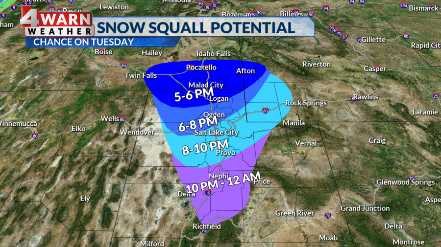
Snow Squalls
These incoming storms bring a moderate to high potential for snow squalls to hit major cities along the Wasatch Front on Tuesday night, and again Wednesday night.
A snow squall is a quick-moving blast of cold air that creates sudden whiteout conditions with the potential to flash-freeze any moisture on roads. Weather officials say there is a long history of deadly traffic accidents associated with snow squalls.
According to Brophy, the timing of these potential squalls could impact drivers during evening commutes, which could lead to dangerous driving conditions.
“With a squall, it’s a short duration of time, but that means a brief period of heavy snow moves in, temperatures drop, visibility drops, and we get the possibility of whiteouts,” she said. “This really impacts travel, with the potential for some very dicey conditions.”
Brophy added: “I would safely pull over if a snow squall warning is issued, and wait it out.”
The Tuesday evening commute most at risk looks to be from Cache Valley into part of Weber and Davis counties, mainly between Layton and Ogden. Later in the evening, the chance of a squall could also impact Salt Lake City, Tooele, Provo, and as far south as Nephi.
Expected Snow
With advisories issued, major cities along the Wasatch Front will see periods of accumulating snow.
Brophy forecasts the Ogden Valley will get hit hard, with Salt Lake, Tooele, Utah, Davis and Utah counties looking at accumulating snow. Wasatch Front valleys can expect 4-10 inches of snow through Thursday, with higher totals between 8-16 inches expected for the benches. Northern Utah mountain valleys, including the Wasatch Back, could see between 10 and 20 inches stack up.
The storm dips into central Utah, where valleys will see between 3 to 6 inches of snow and the mountains will pick up between 8 to 16 inches of snow through Thursday. Snow amounts lessen the further south and east you go, but Castle Country and the Uinta Basin could see a few inches, while valleys in southern Utah could pick up anywhere from a trace to 3 inches over the next two days.
“The southern mountains could get between 4 to 8 inches of fresh snow, which is needed to help boost snowpack,” Brophy said. “Cold enough air is present that there’s even a chance St. George, in the southwest corner of our state, could see snow overnight Wednesday into Thursday morning. It would be a trace to an inch, but the timing of precipitation allows for the chance.”
Snow Potential For The Weekend
This active winter weather pattern continues late week and is expected to continue this weekend, as another strong, cold storm could hit the Beehive State, Brophy said.
These back-to-back snowstorms will help the state catch up on its snowpack deficit following a relatively dry December. Below-average temperatures are also expected for the next week, with chilly days and frigid nights.

For the latest news, weather, sports, and streaming video, head to ABC4 Utah.

