Winter Storm Watch, Flood Watch, Wind Advisory issued for southern lower Michigan
Snow and ice are in the forecast for the area of southern lower Michigan and northern Indiana, to include Hillsdale, Coldwater and Sturgis.
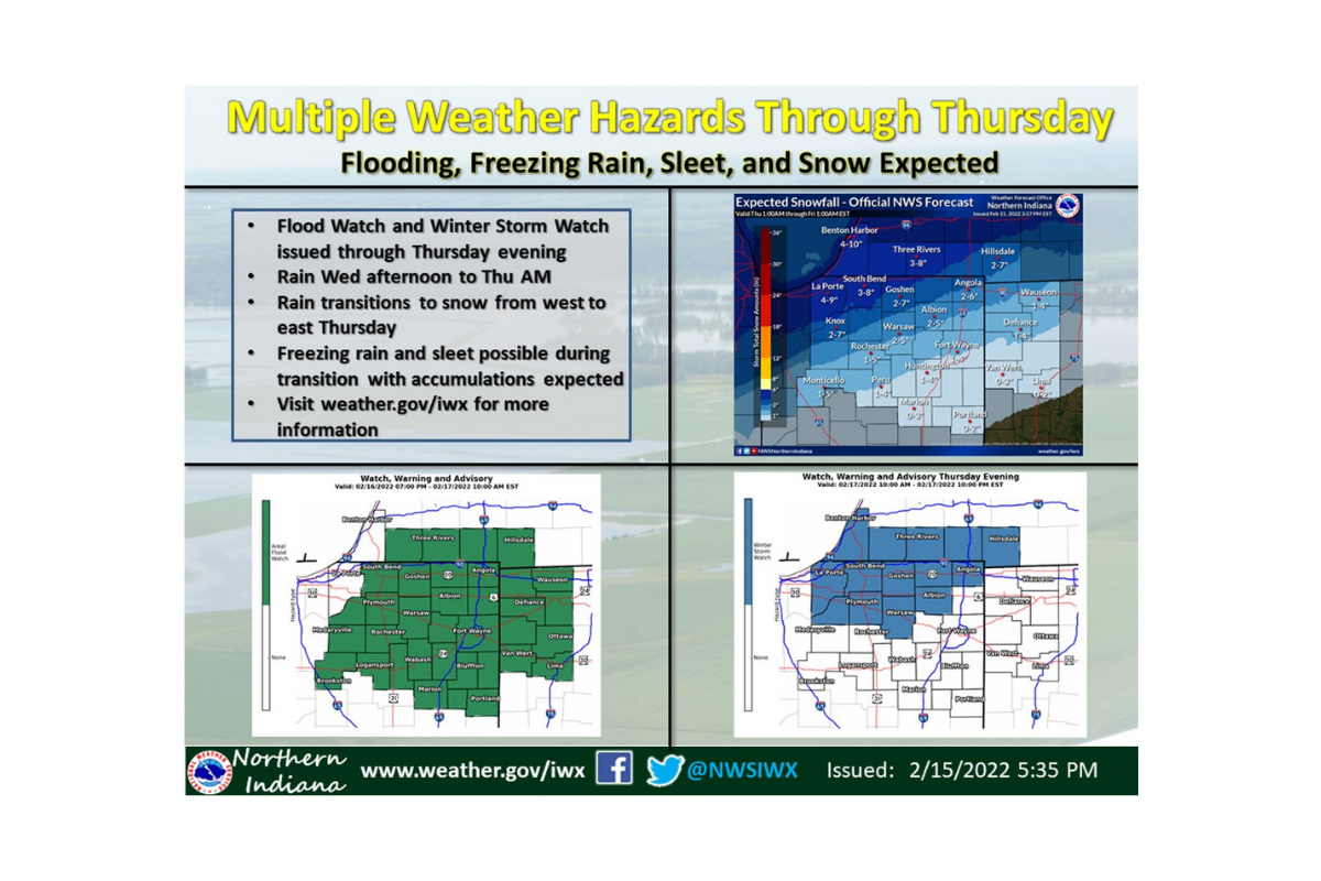
Specifically, the National Weather Service in Northern Indiana is saying rain, freezing rain, snow and sleet, even ice jams, are all possible this evening through Friday. A total snowfall of 3 to 6 inches, along with ice accumulations around one tenth of an inch, are in the forecast for southern lower Michigan.
The forecast will be updated mid-day, but here are the conditions expected as of early this morning:
Winter Storm Watch
URGENT - WINTER WEATHER MESSAGE...CORRECTED National Weather Service Northern Indiana 333 AM EST Wed Feb 16 2022
Steuben-Noble-Kosciusko-Branch-Hillsdale- Including the cities of Angola, Fremont, Kendallville, Ligonier, Albion, Warsaw, Winona Lake, Syracuse, Mentone, Coldwater, Bronson, Hillsdale, Jonesville, and Litchfield
333 AM EST Wed Feb 16 2022 ...WINTER STORM WATCH NOW IN EFFECT FROM THURSDAY AFTERNOON THROUGH THURSDAY EVENING...
* WHAT...Heavy mixed precipitation possible. Total snow accumulations of 3 to 6 inches and ice accumulations around one tenth of an inch possible.
* WHERE...Portions of northern Indiana and southwest Michigan.
* WHEN...From Thursday afternoon through Thursday evening.
* IMPACTS...Plan on slippery road conditions. The hazardous conditions could impact the evening commute. PRECAUTIONARY/PREPAREDNESS ACTIONS... Monitor the latest forecasts for updates on this situation.
Flood Watch
Flood Watch National Weather Service Northern Indiana 339 AM EST Wed Feb 16 2022
St. Joseph IN-Elkhart-Lagrange-Steuben-Noble-De Kalb-Starke-Pulaski- Marshall-Fulton IN-Kosciusko-Whitley-Allen IN-White-Cass IN-Miami- Wabash-Huntington-Wells-Adams-Grant-Blackford-Jay-Cass MI-St. Joseph MI-Branch-Hillsdale-Williams-Fulton OH-Defiance-Henry-Paulding- Putnam-Van Wert-Allen OH- Including the cities of Roanoke, Paulding, Bremen, Bass Lake, Continental, Wabash, Bluffton, Marcellus, Fremont, Payne, Fort Wayne, Defiance, Upland, Coldwater, Columbus Grove, Sturgis, North Manchester, Topeka, Jonesville, Goshen, Montpelier, Decatur, Marion, Lagrange, Rochester, Garrett, Medaryville, Peru, Ossian, Napoleon, Syracuse, Gas City, Brookston, Walkerton, Spencerville, Dowagiac, Mentone, Nappanee, Angola, Hartford City, Bronson, Wauseon, Logansport, Huntington, Grissom AFB, Elkhart, Leipsic, Deshler, Monticello, Sherwood, Archbold, Ligonier, New Carlisle, Francesville, South Whitley, South Bend, Winona Lake, Kendallville, Van Wert, Delta, Akron, Royal Center, Bryan, Litchfield, Ottawa, Ohio City, Albion, Tri-Lakes, Auburn, Edwardsburg, Lima, Antwerp, North Judson, Cassopolis, Mendon, Dunkirk, Berne, Mishawaka, Culver, Edgerton, Knox, Columbia City, Three Rivers, Liberty Center, Hicksville, Swanton, Monon, Hillsdale, Plymouth, Pandora, New Haven, Mexico, Shipshewana, White Pigeon, Winamac, Portland, and Warsaw
339 AM EST Wed Feb 16 2022 /239 AM CST Wed Feb 16 2022/ ...FLOOD WATCH REMAINS IN EFFECT FROM THIS EVENING THROUGH THURSDAY EVENING...
* WHAT...Flooding caused by rain and snowmelt continues to be possible.
* WHERE...Portions of northern Indiana, southwest Michigan and northwest Ohio, including the following areas, in northern Indiana, Adams, Allen IN, Blackford, Cass IN, De Kalb, Elkhart, Fulton IN, Grant, Huntington, Jay, Kosciusko, Lagrange, Marshall, Miami, Noble, Pulaski, St. Joseph IN, Starke, Steuben, Wabash, Wells, White and Whitley. In southwest Michigan, Branch, Cass MI, Hillsdale and St. Joseph MI. In northwest Ohio, Allen OH, Defiance, Fulton OH, Henry, Paulding, Putnam, Van Wert and Williams.
* WHEN...From this evening through Thursday evening.
* IMPACTS...Excessive runoff may result in flooding of rivers, creeks, streams, and other low-lying and flood-prone locations.
* ADDITIONAL DETAILS... - Rainfall between 1 and 2 inches is expected to fall during this period with times of moderate to heavy rain. Frozen ground, ice jams, and additional snow pack melt will help lead to increased runoff leading to minor to moderate river flooding and flooding in low lying areas. -
Http://www.weather.gov/safety/flood
PRECAUTIONARY/PREPAREDNESS ACTIONS... You should monitor later forecasts and be alert for possible Flood Warnings. Those living in areas prone to flooding should be prepared to take action should flooding develop.
Wind Advisory
URGENT - WEATHER MESSAGE National Weather Service Northern Indiana 341 AM EST Wed Feb 16 2022
La Porte-St. Joseph IN-Elkhart-Lagrange-Steuben-Noble-De Kalb- Starke-Pulaski-Marshall-Fulton IN-Kosciusko-Whitley-Allen IN- White-Cass IN-Miami-Wabash-Huntington-Wells-Adams-Grant-Blackford- Jay-Berrien-Cass MI-St. Joseph MI-Branch-Hillsdale-Williams- Fulton OH-Defiance-Henry-Paulding-Putnam-Van Wert-Allen OH- Including the cities of Michigan City, La Porte, South Bend, Mishawaka, New Carlisle, Walkerton, Elkhart, Goshen, Nappanee, Lagrange, Topeka, Shipshewana, Angola, Fremont, Kendallville, Ligonier, Albion, Auburn, Garrett, Knox, North Judson, Bass Lake, Winamac, Francesville, Medaryville, Plymouth, Bremen, Culver, Rochester, Akron, Warsaw, Winona Lake, Syracuse, Mentone, Columbia City, Tri-Lakes, South Whitley, Fort Wayne, New Haven, Monticello, Monon, Brookston, Logansport, Royal Center, Peru, Grissom AFB, Mexico, Wabash, North Manchester, Huntington, Roanoke, Bluffton, Ossian, Decatur, Berne, Marion, Gas City, Upland, Hartford City, Montpelier, Portland, Dunkirk, Niles, Benton Harbor, St. Joseph, Fair Plain, Benton Heights, Buchanan, Paw Paw Lake, Dowagiac, Cassopolis, Edwardsburg, Marcellus, Sturgis, Three Rivers, White Pigeon, Mendon, Coldwater, Bronson, Hillsdale, Jonesville, Litchfield, Bryan, Edgerton, Wauseon, Archbold, Swanton, Delta, Defiance, Sherwood, Hicksville, Napoleon, Deshler, Liberty Center, Paulding, Antwerp, Payne, Ottawa, Leipsic, Columbus Grove, Continental, Pandora, Van Wert, Ohio City, Lima, and Spencerville
341 AM EST Wed Feb 16 2022 /241 AM CST Wed Feb 16 2022/ ...WIND ADVISORY IN EFFECT FROM 10 AM EST /9 AM CST/ THIS MORNING TO 7 PM EST /6 PM CST/ THIS EVENING...
* WHAT...South winds 20 to 30 mph with gusts 45 to 50 mph expected.
* WHERE...Portions of northern Indiana, southwest Michigan and northwest Ohio.
* WHEN...From 10 AM EST /9 AM CST/ this morning to 7 PM EST /6 PM CST/ this evening.
* IMPACTS...Gusty winds could blow around unsecured objects. Tree limbs could be blown down and a few power outages may result.
PRECAUTIONARY/PREPAREDNESS ACTIONS... Use extra caution when driving, especially if operating a high profile vehicle. Secure outdoor objects.
Paula Wethington is a digital producer for the USA Today network. Twitter @WethingtonPaula.
This article originally appeared on Sturgis Journal: A Winter Storm Watch is in the forecast for southern lower Michigan

