Winter Storm Watch issued: 3-6 inches of snow, plus ice, expected in southeast Michigan
Monroe and Lenawee counties are included in a Winter Storm Watch for Thursday as a storm system will affect much of southern lower and southeast Michigan with a mix of rain, snow and ice.
Today's weather includes a Wind Advisory, and then a Flood Watch as current snowpack melts under warmer temperatures.
The forecast is expected to be updated mid-day, but here's what the National Weather Service in Detroit had posted this morning.
Winter storm preparations: When bread and milk are on the emergency shopping list

Winter Storm Watch
URGENT - WINTER WEATHER MESSAGE National Weather Service Detroit/Pontiac MI 330 AM EST Wed Feb 16 2022
Sanilac-Genesee-Lapeer-St. Clair-Livingston-Oakland-Macomb- Washtenaw-Wayne-Lenawee-Monroe- Including the cities of Sandusky, Flint, Lapeer, Port Huron, Howell, Pontiac, Warren, Ann Arbor, Detroit, Adrian, and Monroe
330 AM EST Wed Feb 16 2022 ...WINTER STORM WATCH IN EFFECT FROM THURSDAY MORNING THROUGH LATE THURSDAY NIGHT...
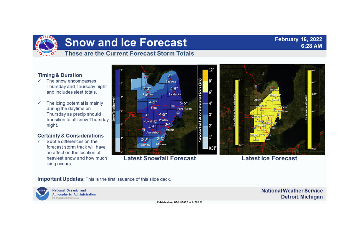
* WHAT...Heavy mixed precipitation possible. Total snow accumulations of 3 to 6 inches and ice accumulations of up to one tenth of an inch possible.
* WHERE...Portions of southeast Michigan.
* WHEN...From Thursday morning through late Thursday night.
* IMPACTS...Plan on slippery road conditions. The hazardous conditions could impact the evening commute.
* ADDITIONAL DETAILS...Rain changes over to a wintry mix including the potential for freezing rain Thursday morning before transitioning to all snow Thursday afternoon-evening. Potential snow and sleet accumulations of 4 to 6 inches are possible particularly for areas along and south of I-69 down to I-94. There is the potential for up to a tenth of an inch of ice accumulation particularly for areas south of M-59.
PRECAUTIONARY/PREPAREDNESS ACTIONS... Monitor the latest forecasts for updates on this situation.

Flood Watch
Flood Watch National Weather Service Detroit/Pontiac MI 418 AM EST Wed Feb 16 2022 .Heavy rain may fall on a deep primed snowpack leading to the melt increasing. Flows in rivers may increase quickly and reach critical levels.
St. Clair-Oakland-Macomb-Washtenaw-Wayne-Lenawee-Monroe- Including the cities of Pontiac, Detroit, Port Huron, Ann Arbor, Adrian, Monroe, and Warren
418 AM EST Wed Feb 16 2022 ...FLOOD WATCH REMAINS IN EFFECT FROM LATE TONIGHT THROUGH THURSDAY AFTERNOON...
* WHAT...Flooding caused by rain and snowmelt continues to be possible.
* WHERE...A portion of southeast Michigan, including the following areas, Lenawee, Macomb, Monroe, Oakland, St. Clair, Washtenaw and Wayne.
* WHEN...From late tonight through Thursday afternoon.
* IMPACTS...Excessive runoff may result in flooding of rivers, creeks, streams, and other low-lying and flood-prone locations.
* ADDITIONAL DETAILS... - The combination of rainfall between 1 and 2 inches and snowmelt will bring the potential for flooding to the area. - http://www.weather.gov/safety/flood
PRECAUTIONARY/PREPAREDNESS ACTIONS... You should monitor later forecasts and be alert for possible Flood Warnings. Those living in areas prone to flooding should be prepared to take action should flooding develop.
Wind Advisory
URGENT - WEATHER MESSAGE National Weather Service Detroit/Pontiac MI 330 AM EST Wed Feb 16 2022
Midland-Bay-Huron-Saginaw-Tuscola-Sanilac-Shiawassee-Genesee- Lapeer-St. Clair-Livingston-Oakland-Macomb-Washtenaw-Wayne- Lenawee-Monroe- Including the cities of Midland, Bay City, Bad Axe, Saginaw, Caro, Sandusky, Owosso, Flint, Lapeer, Port Huron, Howell, Pontiac, Warren, Ann Arbor, Detroit, Adrian, and Monroe
330 AM EST Wed Feb 16 2022 ...WIND ADVISORY IN EFFECT FROM 11 AM THIS MORNING TO 8 PM EST THIS EVENING...
* WHAT...Southwest winds 15 to 25 mph with gusts up to 45 mph expected.
* WHERE...Portions of southeast Michigan.
* WHEN...From 11 AM this morning to 8 PM EST this evening.
* IMPACTS...Gusty winds could blow around unsecured objects. Tree limbs could be blown down and a few power outages may result.
PRECAUTIONARY/PREPAREDNESS ACTIONS... Use extra caution when driving, especially if operating a high profile vehicle. Secure outdoor objects.
Paula Wethington is a digital producer for the USA Today network. Twitter @WethingtonPaula.
This article originally appeared on The Monroe News: Winter Storm Watch, Flood Watch issued for SE Michigan

