Winter storm watches issued as another system looks to bring heavy snow to Utah this weekend
SALT LAKE CITY (ABC4) — After a quick-moving storm brought a dash of snow to northern Utah on Friday, another system is gearing up to dump heavy snow on the Beehive State this weekend, with accumulations possible in the northern valleys.
Along the Wasatch Front, the metro areas of Salt Lake City, Provo and Ogden could see up to a half-foot of snow by Sunday evening, while the northern mountains might get up to 18 inches of powder, with higher totals in the Cottonwoods.
The National Weather Service has issued winter storm watches across Utah, including the northern, central and southern mountains as well as valleys along the Wasatch Front and Wasatch Back.
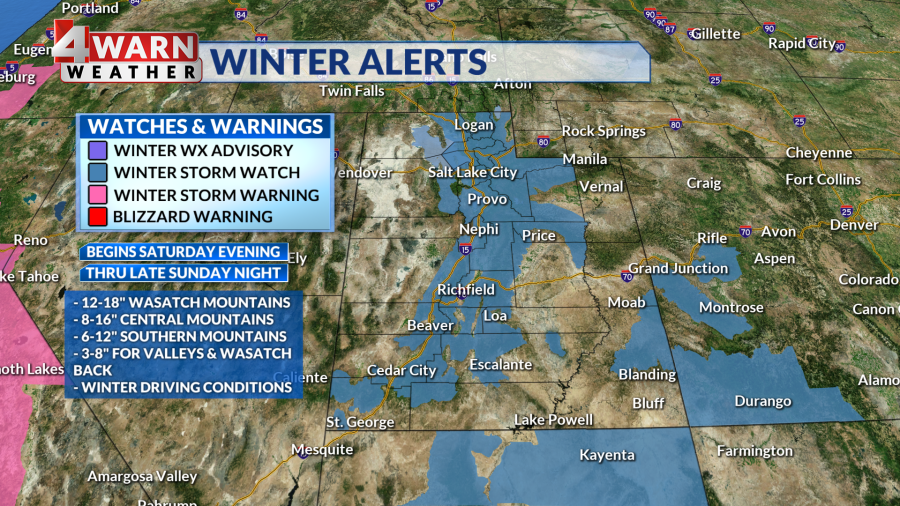
The watches are set to go into effect Saturday evening and extend through Sunday night.
Drivers should expect slick conditions, as snow could accumulate on major thoroughfares like I-15 and I-80. Travel on mountain routes could be treacherous.
John Gleason, a UDOT spokesperson, said crews were out Friday pretreating roads and preparing for a busy weekend.
“We’re ready for a pretty intense next couple of days,” he said.
How much snow?
ABC4 chief meteorologist Alana Brophy said northern valleys could pick up anywhere from 3-6 inches of snow, while southern valleys could to see 1- 3 inches.
The Benches might pick up between 3-7 inches, she added, noting that mountain valleys, like Park City and Morgan, might get between 4-8 inches.
The weekend storm will usher in enough cold air that St. George will see rain turn to snow, and the higher elevations of Washington County, such as Black Ridge on I-15, could get sloppy.

Utah’s mountains will get another healthy, needed dose of powder. Northern mountains will see totals between 12-18 inches with the Cottonwoods seeing anywhere from 1-2 feet.
Central mountains will see 8-14 inches and the high country in the south might see anywhere from a half-foot to a foot of snow, Brophy said.
Frigid air accompanying the storm will linger, creating slick spots on roads and sidewalks. The Monday morning commute could be icy as well, Brophy said, noting that drivers should make sure to plan for a little extra time.
Much-needed powder
Friday’s storm and the one setting up for this weekend are part of a series of storms that will continue to hit Utah into next week.
“We need the snow,” Brophy said, “especially after that dry December.”
Salt Lake City only picked up 2.4 inches of snow in the entire month of December, when the city typically averages over a foot.
Snowpacks across Utah dwindled during the dry stretch over the holidays.

Alison Palmintere, a spokesperson for Ski Utah, said that before Friday’s storm, resorts in northern Utah were roughly 20% below normal for snowfall this time of year.
However, in the shadow of last year’s record-breaking season, it might feel as though Utah was further behind.
“I really don’t think we’re too far behind an average year, and I think these storms this weekend will help knock us up there a little bit,” she said.
Utah resorts, Palmintere noted, have had some of the better conditions this winter when compared to other snow destinations across the country.
Avalanche threat
While Utah skiers and snowboarders will be excited to hit fresh powder, especially in more challenging terrain, this series of back-to-back storms increases the avalanche threat.
Craig Gordon, avalanche forecaster with the Utah Avalanche Center, said that the December dry spell created a weak layer of surface snow, making the base of the mountain snowpack unstable.
“This [new] snow is falling on top of that, it’s going to ramp that avalanche danger up,” he said.
Looking ahead, more snow in on tap in the short-term forecast, with storms possible in the middle and end of next week.
While the storms appear to tracking toward northern and central Utah, it’s too soon to say how much snow might fall.
For the latest news, weather, sports, and streaming video, head to ABC4 Utah.

