Winter weather advisory issued for parts of Rochester region. How much snow will we get?
A winter weather advisory has been issued by the National Weather Service in Buffalo for parts of the Rochester region through Wednesday morning.
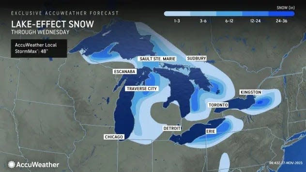
The advisory covers Wayne County, where 4 to 7 inches of lake effect snow is expected on the eastern part of the county. According to the advisory, winds gusting as high as 35 mph will produce blowing and drifting snow.
Motorists should plan on slippery and hazardous road conditions that could impact the evening commute, according to the Weather Service.
The advisory runs from 10 a.m. Tuesday through 7 a.m. Wednesday.
Lake effect snow warning issued for Wyoming County, western New York
A lake effect snow warning was issued for parts of western New York, including Wyoming County, which is predicted to see between 8 and 16 inches of snow by Wednesday morning.
According to the National Weather Service in Buffalo, the warning runs through 7 a.m. Wednesday and covers Wyoming, Chautauqua, Cattaraugus and southern Erie counties, south of Buffalo and near Lake Erie. Wind gusts up to 35 mph are also predicted, which could yield difficult road conditions with blowing and drifting snow.
The heaviest snow bands could bring as much as 20 inches of snow across the Chautauqua Ridge by Wednesday morning, forecasters said. The heaviest snow is expected through Tuesday, when more than 1 inch of snow per hour could fall within the heaviest snow bands.
As of 7 a.m. Tuesday, 9.5 inches of snow was on the ground in Wyoming County - with 8 inches in Warsaw, 6.5 inches in Attica and 4.5 inches in Silver Springs.
East Aurora in Erie County, tallied the most snow in western New York mid-way through the storm, with 16.5 inches of snow on the ground as of 11:30 p.m. Monday, according to the Weather Service.
Lake effect snow warning issued for Oswego, Jefferson and Lewis counties
A similar lake effect snow warning was issued for Oswego, Jefferson and Lewis counties, where 1 to 2 feet of snow is possible by Wednesday morning. That warning runs through 7 a.m. Wednesday. Within the heart of the lake effect snow band, snowfall rates will approach 3 inches per hour, according to the Weather Service.
Nearly two feet of snow fell in Highmarket, Lewis County, as of daybreak on Tuesday, according to the Weather Service. Other parts of the county saw between 8 inches (Lowville) and 17.5 inches (Osceola and Glenfield). As of 8:30 a.m. Tuesday, 10.5 inches of snow was recorded in Richland, Oswego County.
Weather in Rochester NY: How much snow will Rochester get?
Rochester could see some lake effect snow, with a half-inch to an inch on Tuesday, said Jason Alumbaugh, a meteorologist with the National Weather Service in Buffalo.
"What people will notice is that it is cold," Alumbaugh said. Tuesday's high is predicted to remain in the low 30s, but with the wind chill, it will feel more like the teens, he said.
Lows are predicted to drop to the mid-20s Tuesday into Wednesday as well. The normal high in Rochester in late November is 45.
In Rochester, 0.2 inches were measured at the Frederick Douglass Greater Rochester International Airport as of 7 a.m. Tuesday. Two inches were on the ground in Mount Morris, Livingston County, and 0.8 inches were tallied in Le Roy, Genesee County, according to the Weather Service.
[8:15AM Radar Update]
Lake effect snow off Lake Erie is expected to intensify through this morning. Winds veering NW should direct the heaviest snow further southeast into the higher terrain south of Buffalo (Boston Hills). Snowfall rates up to 1" per hour possible. pic.twitter.com/olWg7ZU2PG— NWS Buffalo (@NWSBUFFALO) November 28, 2023
What is lake effect snow?
When snow piles up in places such as Rochester and Buffalo in western New York or Marquette in the Upper Peninsula of Michigan, people start talking about the lake effect.
Lake effect snow, which can last for only a few minutes or a range spanning several days, develops from narrow bands of clouds that form when cold, dry arctic air passes over a large, relatively mild lake.
As the cold air passes over the unfrozen and "warm" waters of the Great Lakes, warmth and moisture are transferred into the lowest portion of the atmosphere, the National Weather Service says. The air rises, and clouds form and grow into narrow bands that produce 2 to 3 inches of snow an hour or more.
Wind direction is also a key component in determining which areas will receive lake effect snow. Heavy snow may be falling in one spot, while the sun may be shining just a mile or two away in either direction.
In Buffalo, the region receives most of its lake effect snow from Lake Erie, while Rochester's lake effect snow comes from Lake Ontario, according to the National Weather Service in Buffalo.
Buffalo tends to see fewer, but more intense bands of lake effect snow, resulting in larger amounts of heavy snow that can deposit up to 4 inches an hour.
Rochester, on the other hand, sees smaller but more frequent amounts of lake effect snow, often lasting days at a time.
These snows typically occur only in the fall or early winter, before the lakes freeze over. (But if the lakes don't freeze, lake effect snow can occur throughout the winter and into the spring.)
This article originally appeared on Rochester Democrat and Chronicle: Rochester NY Weather: Winter weather advisory, warning issued for area
