Winter weather advisory for Sioux Falls set for Thursday morning
Sioux Falls will be under a winter weather advisory as the city braces for another round of snowfall in what has become the second-snowiest winter in the city's history.
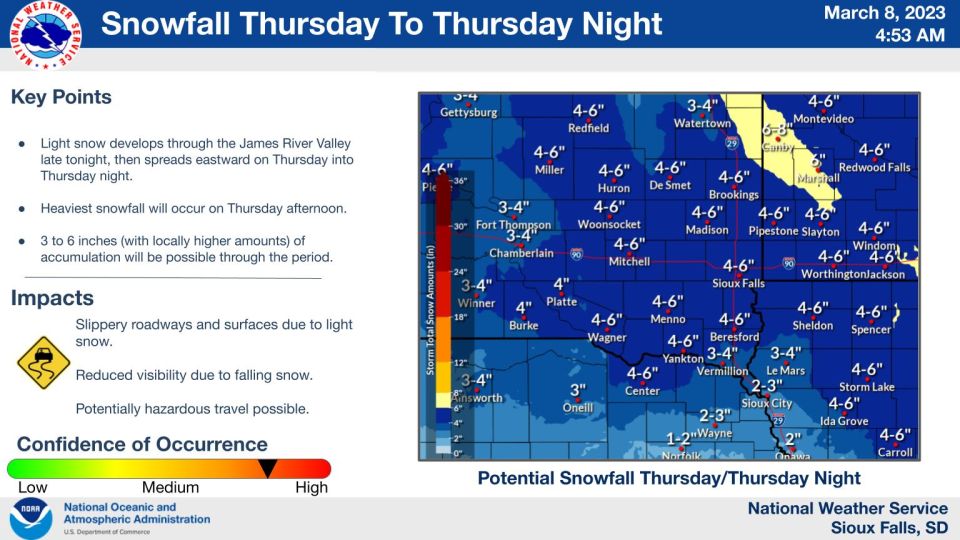
The advisory is in effect from 6 a.m. Thursday until midnight Friday, by which time the city is expected to see anywhere between 3 to 6 inches of snow, according to the National Weather Service.
While light snowfall is expected through Wednesday, significant impacts are expected to begin Thursday morning, with the heavier snow accompanied by winds up to 35 miles per hour. Snow is expected to return Saturday, though forecasts do not say whether any accumulation is likely at this time.
Street Operations Manager Dustin Hansen said Wednesday morning that a snow alert could be called anytime between Friday and Sunday, depending on when emergency routes are cleared and snowfall stops.
Hansen asked residents keep an eye on the city's website, including the new snow alert tracker, to make sure their vehicles were off the street when it came time for their roads to be plowed.
More:City debuts tracker showing what streets have been plowed throughout Sioux Falls
Following last month's storm, Hansen said the city has hauled more than 25,000 loads of snow to eight snow dumps. But he remained hopeful that warmer temperatures would aid with some of the cleanup.
"Spring is just around the corner," he said.
This article originally appeared on Sioux Falls Argus Leader: Sioux Falls will be under winter weather advisory starting Thursday

