Winter weather: Speed limit restrictions lifted following snow in central Pennsylvania
Update Saturday night:
PennDOT lifted speed restrictions on major roads at about 6 p.m.
Update Saturday:
The region is under a winter storm warning until 5 p.m. Snow is now falling after heavy rain fell before dawn.
The state Department of Transportation has reduced speed limits to 45 mph on major roads in the region, including Adams, Cumberland, Dauphin, Franklin, Lancaster, Lebanon, Perry and York counties.
Drivers are asked to avoid unnecessary travel.
If you do head out, you will see speeds reduced to 45 mph on the following highways:
Interstate 78 in Lebanon County
Interstate 81 in Franklin, Cumberland and Dauphin counties
Interstate 83 in York and Dauphin counties
Interstate 283 in Dauphin County
Route 15 in Adams County
Route 22 in Perry and Dauphin counties
Route 30 in York and Adams counties
Route 222 in Lancaster County
Route 283 in Lancaster County
Route 322 in Dauphin County, and
Route 581 in Cumberland County.
Commercial vehicles must stay in the right lane during this time.
Although PennDOT crews have been treating roads, drivers should be alert for areas of ice and snow. Crews will continue to treat the roads until they are clear.
Reported previously:
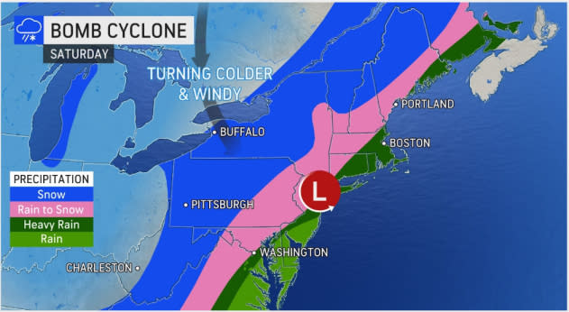
A storm that was only expected to deliver minimal snow to south central Pennsylvania this weekend now could dump up to half a foot on the area.
The storm is taking a track to bring more snow to the area than originally predicted, Mike Dangelo, a meteorologist with the National Weather Service, said Friday.
The agency had issued a winter storm watch for Adams, Franklin, Lebanon and York counties on Friday morning. The weather service changed it to a warning at lunchtime Friday. The latest forecast calls for 4 to 6 inches of snow.
AccuWeather.com is predicting one to three inches for York County, but Adams and Franklin counties could see three to six inches, senior meteorologist Paul Walker said.
Below normal: Central Pennsylvania is in a 'snow drought.' Will it change in the next few weeks?
Forecast: How much snow will Pennsylvania get this week? See projected inch counts
For subscribers: A nor'easter is in the forecast, but predicting its impact on central Pa. is a nightmare
Snowfall could be heavy at times, and wind gusts could reach up to 45 mph, which would blow the snow, Dangelo said. Travel will likely be tricky.
"It's not going to be a nice day to go travel anywhere," he said of Saturday.
Travel restrictions issued for the state
The state Department of Transportation has implemented some travel restrictions around the state for Saturday.
Drivers are urged not to travel unless necessary, a news release states.
Tier 1 restrictions for the Pennsylvania Turnpike start at 5 a.m. Friday and are in place for New Stanton (Exit 75) to Breezewood (Exit 161).
The same restriction go into effect at 7 a.m. Saturday for Interstate 81 from Interstate 78 to Interstate 80, PennDOT says.
Vehicles not permitted on the road under the Tier 1 restrictions include:
Tractors without trailers;
Tractors towing unloaded or lightly loaded enclosed trailers, open trailers or tank trailers;
Tractors towing unloaded or lightly loaded tandem trailers;
Enclosed cargo delivery trucks that meet the definition of a CMV;
Passenger vehicles (cars, SUV’s, pickup trucks, etc.) towing trailers;
Recreational vehicles/motorhomes;
School buses, commercial buses and motor coaches not carrying chains or Alternate Traction Devices (ATD’s); and
Motorcycles.
What to expect with the storm
Friday is expected to be warm with temperatures in the 55- to 60-degree range. Cold air will rush in late Friday night into Saturday, dropping the mercury, Dangelo said.
Rain is anticipated to start falling after midnight and then change over to snow. The storm is expected to last about six to eight hours.
The intensity of the storm, how quickly the temperatures fall and how soon the precipitation changes over will be key in how much snowfall the area receives, Walker said.
He urged residents to clean up from the storm before it freezes solid.
On Thursday, the National Weather Service had been predicting one to two inches of snow for south central Pennsylvania. But the agency revised its forecast overnight Thursday, bumping up the snowfall amounts.
Meteorologists are keeping an eye on the storm, which is expected to deepen rapidly. Some are calling it a bomb cyclone — a winter hurricane.
It's when a midlatitude cyclone rapidly intensifies and the atmospheric pressure drops at least 24 milibars during a 24-hour period, according to the National Oceanic and Atmospheric Administration.
It's expected to stay cold this weekend. Wind chills on Sunday will be near zero, Dangelo said.
Whatever falls, though, will not stick around long.
Spring-like weather is anticipated for early next week.
Monday is expected to be partly sunny with a high near 60 degrees, Walker said. Tuesday will be cloudy with highs in the mid-60s.
This article originally appeared on York Daily Record: Winter bomb cyclone this weekend to bring more snow to central PA
