Snow blankets parts of Mississippi
The National Weather Service issued a winter storm warning for portions of northern Mississippi, lasting from Saturday night and into Sunday afternoon.
The latest on snow in Mississippi: 'We are looking at a rather chilly day' after 7-9 inches reported
Accumulating snow is expected through Sunday morning, particularly for locations along and north of Interstate 20. The snow could be mixed with drizzle at times and should end by around midday, according to a NWS tweet. The winter storm warning ends at 3 p.m. Sunday for the following counties:
Alcorn
Benton
Coahoma
DeSoto
Lafayette
Marshall
Panola
Prentiss
Quitman
Tallahatchie
Tate
Tippah
Tishomingo
Tunica
Union
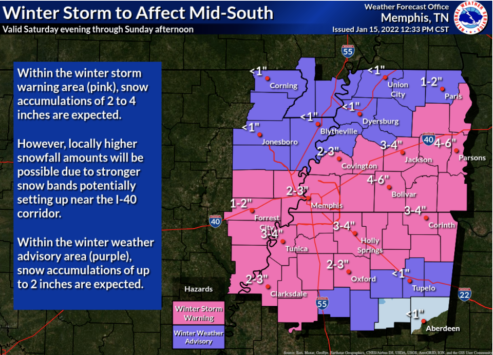
As temperatures drop to the low to mid-30s Saturday evening, rain will transition to light snow throughout most of the state. Southeast Mississippi will only have rain.
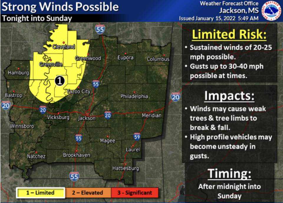
Up to 2 inches of snow is possible for Cleveland, Greenville, Greenwood, Hamburg, Eupora, Yazoo City and parts of Columbus. Snowfall is expected to begin around midnight and end Sunday morning.
2:31 am - Snow accumulation in Brandon, Mississippi near the Rez.#mswx @NWSJacksonMS @WCBIWEATHER pic.twitter.com/A9VOdNcpfo
— Mann's Foggy Bayou Calls (@FoggyMann) January 16, 2022
Bella Donna’s first snow! You heard me right, SNOW in Mississippi!! About one inch y’all. #puppylove pic.twitter.com/JCyAI02CTJ
— Nechole Keekah Sullivan (@Lotus_Luvr) January 16, 2022
The National Weather Service urged residents to stay home Sunday in case the roads are impacted by snowfall. If the storm brings drier snow, it has the ability to blow around causing low visibility on roadways.
Meteorologists said bridges and roads may become slick with snow, but there is little likelihood there will be a build-up of ice.
The storm system has the potential to bring 20 to 25 mph winds with gusts up to 30 to 40 mph late Saturday and into Sunday morning for Cleveland, Greenville and parts of Greenwood and Yazoo City. Winds will make the temperature feel as though it's in the 20s, despite being in the 30s.
Meteorologists said high winds could lead to downed trees and power outages.
Snowfall across the state is expected to end Sunday morning, according to the National Weather Service. Sunday temperatures in Mississippi will range from the upper 30s northeast to the mid-40s southwest.
85 DEGREES ONE DAY, SNOW THE NEXT: Wild weather explained and what's ahead
GET READY: A major snowstorm is forecast to roar across the Midwest, South and East Coast
Safety tips for power outages amid winter weather:
Stay warm with layered clothing and by rolling towels where there are cracks in doors and windows.
Keep a watchful eye on candles and space heaters.
Use portable generators outdoors at least 20 feet from doors, windows and garages to avoid carbon monoxide poisoning.
Mississippi weather radar
Have a health story? Or a health-related tip? Send it along to shaselhorst@gannett.com, on Twitter at @HaselhorstSarah or call 601-331-9307.
This article originally appeared on Mississippi Clarion Ledger: Weather in Mississippi: Snow blankets parts of the state

