Winter Weather Round Two: Davidson and Randolph counties brace for another chance of snow
While lingering ice and snow from last week's winter storm still remain, Davidson and Randolph counties are preparing for a second round of frozen precipitation.
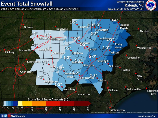
The National Weather Service has issued a winter weather advisory for the area from 4 p.m. Thursday to 4 a.m. Saturday. Forecasters have predicted up to two inches of snow and a possible glazing of ice through central North Carolina.
Areas east of Raleigh are expected to see greater accumulations up to 3 or 4 inches through Saturday morning.
Want to know more about what is happening in your county? Support local journalism and subscribe to The Dispatch or The Courier-Tribune.
"Residents of central North Carolina should be prepared to stay off the roads, expect to remain home (or at work if applicable) from Thursday night through at least Saturday. Expect power outages during that time. Finally, take the opportunity now to stock up on supplies that you would need for at least a 72-hour period of time at home or work," the NWS warned.
On Thursday, light rain will begin to change to snow late in the day, starting mostly north and east of Randolph and Davidson counties. A coating of up to an inch of snow or sleet is possible, along with a glaze of ice.
There continues to be uncertainty regarding how much precipitation will fall on Friday. As of Thursday morning, the National Weather service predicts snow will begin again Friday afternoon and could continue through 2 a.m. Saturday.
More: Weekend storm leaves minimal impact on power outages and travel in Davidson and Randolph counties
Snow accumulation totals for Friday vary with the NWS estimating 1 inch for parts of Randolph County and less than an inch in Davidson County.
The biggest issue identified with this storm system is the possibility of widespread black ice. Wet roads could freeze Thursday night when temps drop below freezing and remain at those temperatures through Friday with additional precipitation.
A high of 35 degrees is forecasted on Saturday which could contribute to travel hazards as the snow melts and refreezes overnight.
General news reporter Sharon Myers can be reached at sharon.myers@the-dispatch.com. Follow her on Twitter @LexDispatchSM.
This article originally appeared on The Dispatch: Area braces for second round of winter weather through Saturday

