Wintry chill to follow snowstorm in Denver into Thanksgiving weekend

As the holiday season officially gets underway this week, AccuWeather meteorologists say travelers should be on alert for the next winter storm to sweep across parts of the western and central United States.
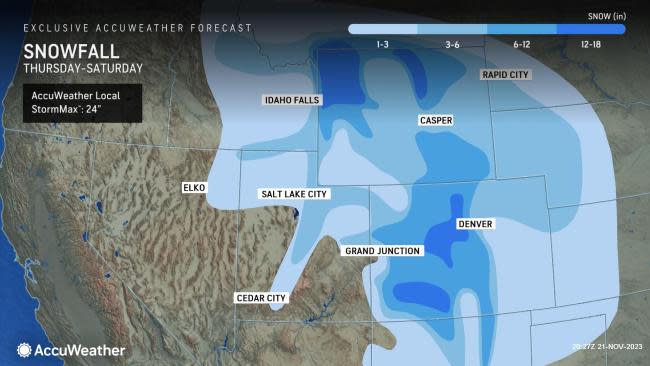
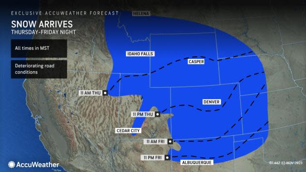
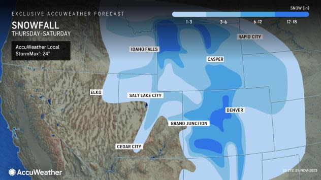
"Snow is expected to start in the northern Rockies on Thanksgiving Day but spread southeastward into Friday and Saturday, encompassing most of the southern Rockies," AccuWeather Meteorologist Emma Belscher said.
The high terrain in Colorado, Wyoming and Utah may have some of the highest snowfall totals, but impactful snowfall is expected across the entire region through the Thanksgiving holiday, followed by a deep freeze.
 |
The city of Denver is no stranger to late-autumn snow. However, outside of snowfall ahead of Halloween, there hasn't been much in the Mile High City so far this season. The first 20 days of November have been snow-free, even though the historical average snowfall for the entire month is 4.5 inches of snow. So far this season, the only accumulating snow came during a two-day storm on Oct. 28 and 29, when 7.5 inches fell.
Currently, AccuWeather forecasters are expecting about 2-4 inches of snow in Denver. Snowfall totals are expected to increase drastically as elevation increases to the west of the Denver Metro area. More than a foot of snow could fall on the highest mountain peaks.
 |
"The widespread nature of this winter storm, coinciding with a higher volume of travelers during the Thanksgiving holiday, is likely to cause travel disruptions," explained Belscher.
These travel woes are likely to include delays for flights in and out of cities in the Rockies, as well as for motorists taking to the roads as well. Mountain passes along Interstate 70 through Colorado are likely to pick up accumulating snow, leading to slippery conditions.
Have the app? Unlock AccuWeather Alerts™ with Premium+
AccuWeather's long-range forecasting team expects that the El Niño pattern in place with above-normal water temperatures around the equator in parts of the Pacific Ocean could help to bring more snow to the region throughout the winter season.
A southerly storm track from Southern California into the Plains, which develops often in this weather pattern, could bring bigger storms through southern Colorado, promoting opportunities for above-historical-average snowfall.
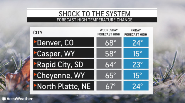
Ahead of the wintry weather, high temperatures in Rapid City, South Dakota, and Colorado Springs, Colorado, are forecast to top out in the lower or middle 60s on Wednesday. Temperatures this high are about 10 degrees above the historical average and more typical of mid-October.
 |
The abnormal warmth has been a theme across much of Colorado already in November. Through Nov. 21, Colorado Springs is running 6.2 degrees Fahrenheit above average, and Denver has recorded temperatures an even 7 degrees above the historical average.
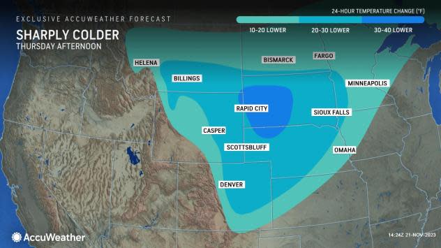
"The drop in temperature expected across the Rockies and Front Range will be nothing short of dramatic," said Belscher.
As the winter storm hits, temperatures will plummet into the teens and 20s, with high temperatures dropping as much as 40 degrees Fahrenheit in less than 48 hours. Values this low across the Rockies and into the Plains are more akin to December.
 |
Although these temperature values will not be challenging daily records, they will bring quite a shock to the system for residents in the region.
Those celebrating the holiday weekend outdoors or rushing from store to store starting their holiday shopping will want to bundle up with extra layers.
Want next-level safety, ad-free? Unlock advanced, hyperlocal severe weather alerts when you subscribe to Premium+ on the AccuWeather app. AccuWeather Alerts™ are prompted by our expert meteorologists who monitor and analyze dangerous weather risks 24/7 to keep you and your family safer.
